
FCCInfo.com
A Service of Cavell, Mertz & Associates, Inc.
(855) FCC-INFO
|
|
W24FB-D from 10/02/2012 |
|
|
||||||||||||||||
|
|
Status: License Application Accepted: 04/05/2023 License Expires: 08/01/2029 File Number: -0000213530 FCC Website Links: LMS Facility Details This Application Other W24FB-D Applications Including Superseded Applications Mailing Address Correspondence for W24FB-D Correspondence related to application -0000213530 Service Contour - Open Street Map or USGS Map (51 dBu) Service Contour - KML / Google Earth (51 dBu) Rabbit Ears Info Search for W24FB-D Site Location: 39-14-32.5 N 87-23-28.6 W (NAD 83) Site Location: 39-14-32.4 N 87-23-28.5 W (Converted to NAD 27) ERP: 15 kW Polarization: Elliptically polarized R/C AGL: 106.7 m (350 ft.) R/C AMSL: 275.6 m (904 ft.) Emission Mask: Full Service Site Elevation: 168.9 m. (554 ft.) Height Overall*: 304.5 m (999 ft.) (* As Filed In This Application, may differ from ASR Data, Below.) Directional Antenna - Antenna Make/Model: Propagation System Inc PSILP8OI Antenna ID: 20499 Polarization: Elliptically polarized | ||||||||||||||||||
| Antenna Data for Antenna Id: 20499 W24FB-D LD File: -0000213530 Propagation System Inc - PSILP8OI Service: LD Standard Pattern: Y | 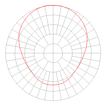 | ||||||||||||||||||
| Azimuth | Ratio | Azimuth | Ratio | Azimuth | Ratio | Azimuth | Ratio | ||||||||||||
| 0 | 1.000 | 10 | 1.000 | 20 | 0.980 | 30 | 0.950 | ||||||||||||
| 40 | 0.910 | 50 | 0.870 | 60 | 0.820 | 70 | 0.760 | ||||||||||||
| 80 | 0.710 | 90 | 0.660 | 100 | 0.630 | 110 | 0.610 | ||||||||||||
| 120 | 0.600 | 130 | 0.600 | 140 | 0.620 | 150 | 0.640 | ||||||||||||
| 160 | 0.660 | 170 | 0.670 | 180 | 0.670 | 190 | 0.670 | ||||||||||||
| 200 | 0.660 | 210 | 0.640 | 220 | 0.620 | 230 | 0.600 | ||||||||||||
| 240 | 0.600 | 250 | 0.610 | 260 | 0.630 | 270 | 0.660 | ||||||||||||
| 280 | 0.710 | 290 | 0.760 | 300 | 0.820 | 310 | 0.870 | ||||||||||||
| 320 | 0.910 | 330 | 0.950 | 340 | 0.980 | 350 | 1.000 | ||||||||||||
Structure Registration Number 1027196 Structure Type: GTOWER Registered To: Nexstar Media Inc. Structure Address: 0.1 Miles West Of U.s. Hwy 41 And 0.2 Miles South Of E County Rd 1100 N Farmersburg, IN County Name: Sullivan County ASR Issued: 08/18/2021 Date Built: 07/01/1965 Site Elevation: 168.9 m (554 ft.) Structure Height: 272 m (892 ft.) Height Overall: 304.5 m (999 ft.) Overall Height AMSL: 473.4 m (1553 ft.) FAA Determination: 08/11/2021 FAA Study #: 2021-AGL-7495-OE FAA Circular #: 70/7460-1M Paint & Light FAA Chapters: 3, 4, 5, 15 PRIOR STUDY 2019-AGL-17883-OE 39-14-32.5 N 87-23-28.6 W (NAD 83) 39-14-32.4 N 87-23-28.5 W (Converted to NAD 27) |
14 Tuxedo Drive Beaufort, SC 29907 Phone: 717-226-3535 Limited Liability Company | Title: Manager Date: 04/05/2023 Application Certifier Lowcountry 34 Media, Llc 14 Tuxedo Drive Beaufort, SC 29907 Applicant Darryl K DeLawder Delawder Communications, Inc. P.o. Box 1095 Ashburn, VA 20146 President Davina Sashkin, Esq Wilkinson Barker Knauer, Llp 1800 M Street, Nw Suite 800n Washington, DC 20036 | |||||||||||||||||