
FCCInfo.com
A Service of Cavell, Mertz & Associates, Inc.
(855) FCC-INFO
|
|
|
|
|
||||||||||||||||
|
|
Status: License Application Accepted: 04/11/2023 License Expires: 04/01/2030 File Number: -0000213732 FCC Website Links: LMS Facility Details This Application Other K04QV-D Applications Including Superseded Applications Mailing Address Correspondence for K04QV-D Correspondence related to application -0000213732 Service Contour - Open Street Map or USGS Map (43 dBu) Service Contour - KML / Google Earth (43 dBu) Rabbit Ears Info Search for K04QV-D Site Location: 47-32-27.0 N 115-19-05.0 W (NAD 83) Site Location: 47-32-27.2 N 115-19-01.5 W (Converted to NAD 27) ERP: 0.1 kW Polarization: Horizontally polarized R/C AGL: 14.2 m (47 ft.) R/C AMSL: 1566.2 m (5138 ft.) Emission Mask: Simple Site Elevation: 1552 m. (5092 ft.) Height Overall*: 20 m (66 ft.) (* As Filed In This Application, may differ from ASR Data, Below.) Directional Antenna - Antenna Make/Model: Scala HDCA-5 ARRAY Antenna ID: 94990 Polarization: Horizontally polarized
| ||||||||||||||||||
| Antenna Data for Antenna Id: 94990 K04QV-D LD File: -0000213732 Scala - HDCA-5 ARRAY Service: LD Standard Pattern: Y | 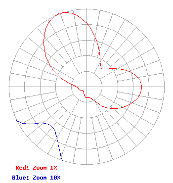 | ||||||||||||||||||
| Azimuth | Ratio | Azimuth | Ratio | Azimuth | Ratio | Azimuth | Ratio | ||||||||||||
| 0 | 0.814 | 10 | 0.644 | 20 | 0.481 | 30 | 0.355 | ||||||||||||
| 40 | 0.304 | 50 | 0.355 | 60 | 0.457 | 70 | 0.576 | ||||||||||||
| 80 | 0.668 | 90 | 0.707 | 100 | 0.688 | 110 | 0.621 | ||||||||||||
| 120 | 0.536 | 130 | 0.440 | 140 | 0.332 | 150 | 0.216 | ||||||||||||
| 160 | 0.158 | 170 | 0.146 | 180 | 0.144 | 190 | 0.126 | ||||||||||||
| 200 | 0.096 | 210 | 0.076 | 220 | 0.068 | 230 | 0.073 | ||||||||||||
| 240 | 0.094 | 250 | 0.106 | 260 | 0.107 | 270 | 0.129 | ||||||||||||
| 280 | 0.207 | 290 | 0.374 | 300 | 0.540 | 310 | 0.699 | ||||||||||||
| 320 | 0.845 | 330 | 0.958 | 340 | 1.000 | 350 | 0.944 | ||||||||||||
Structure Registration Number 1258591 Structure Type: GTOWER Registered To: Western Sanderson County TV District Structure Address: Clark Mtn. Thompson Falls, MT County Name: Sanders County ASR Issued: 12/16/2022 Date Built: 12/30/2006 Site Elevation: 1552 m (5092 ft.) Structure Height: 20 m (66 ft.) Height Overall: 20 m (66 ft.) Overall Height AMSL: 1572 m (5157 ft.) FAA Determination: 12/12/2022 FAA Study #: 2022-ANM-5364-OE Paint & Light FAA Chapters: NONE PRIOR STUDY 2007-ANM-1282-OE 47-32-27.0 N 115-19-05.0 W (NAD 83) 47-32-27.2 N 115-19-01.5 W (Converted to NAD 27) |
P.o. Box 519 Thompson Falls, MT 59873 Phone: 406-827-4100 Government Entity | Title: Consulting Engineer Date: 04/11/2023 Application Certifier THOMPSON FALLS TV DISTRICT Thompson Falls Tv District P.o. Box 519 Thompson Falls, MT 59873 Applicant Charlie Cannaliato Canyon Tv 200 Evans Avenue Missoula, MT 59801 Consulting Engineer Susan Hansen B. W. St. Clair 2305 Vida Shaw Rd. New Iberia, LA 70563 CONSULTANT Jerry McDonald Thompson Falls Tv District Po Box 519 Thompson Falls, MT 59873 President | |||||||||||||||||