
FCCInfo.com
A Service of Cavell, Mertz & Associates, Inc.
(855) FCC-INFO
|
|
|
|
|
||||||||||||||||
|
|
Status: License Application Accepted: 05/02/2023 License Expires: 10/01/2029 File Number: -0000214438 FCC Website Links: LMS Facility Details This Application Other W30DQ-D Applications Including Superseded Applications Mailing Address Correspondence for W30DQ-D Correspondence related to application -0000214438 Service Contour - Open Street Map or USGS Map (51 dBu) Service Contour - KML / Google Earth (51 dBu) Rabbit Ears Info Search for W30DQ-D Site Location: 46-03-36.0 N 84-05-57.0 W (NAD 83) Site Location: 46-03-35.9 N 84-05-56.9 W (Converted to NAD 27) ERP: 10 kW Polarization: Elliptically polarized Electrical Beam Tilt: 1.00 degree R/C AGL: 106 m (348 ft.) R/C AMSL: 335.8 m (1102 ft.) Emission Mask: Full Service Site Elevation: 229.8 m. (754 ft.) Height Overall*: 343.2 m (1126 ft.) (* As Filed In This Application, may differ from ASR Data, Below.) Directional Antenna - Antenna Make/Model: DIELECTRIC DIE TLP - 8F/VP-R Antenna ID: 1010667 Polarization: Elliptically polarized | ||||||||||||||||||
| Antenna Data for Antenna Id: 1010667 W30DQ-D LD File: -0000214438 DIELECTRIC - DIE TLP - 8F/VP-R Service: LD Standard Pattern: N Pattern and Field Values Include a 280° Clockwise Rotation | 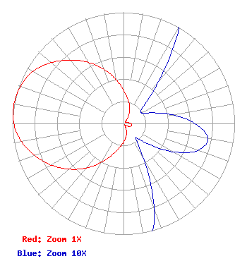 | ||||||||||||||||||
| Azimuth | Ratio | Azimuth | Ratio | Azimuth | Ratio | Azimuth | Ratio | ||||||||||||
| 0 | 0.296 | 10 | 0.223 | 20 | 0.165 | 30 | 0.101 | ||||||||||||
| 40 | 0.049 | 50 | 0.023 | 60 | 0.019 | 70 | 0.028 | ||||||||||||
| 80 | 0.045 | 90 | 0.064 | 100 | 0.077 | 110 | 0.071 | ||||||||||||
| 120 | 0.051 | 130 | 0.028 | 140 | 0.017 | 150 | 0.035 | ||||||||||||
| 160 | 0.080 | 170 | 0.125 | 180 | 0.168 | 190 | 0.224 | ||||||||||||
| 200 | 0.304 | 210 | 0.409 | 220 | 0.525 | 230 | 0.640 | ||||||||||||
| 240 | 0.750 | 250 | 0.849 | 260 | 0.932 | 270 | 0.987 | ||||||||||||
| 280 | 1.000 | 290 | 0.983 | 300 | 0.939 | 310 | 0.850 | ||||||||||||
| 320 | 0.745 | 330 | 0.634 | 340 | 0.521 | 350 | 0.405 | ||||||||||||
Structure Registration Number 1002423 Structure Type: LTOWER Structure Address: .5 Mi W Of M-48 And Traynor Rd Goetzville, MI County Name: Chippewa County ASR Issued: 02/14/2018 Date Built: 02/15/2018 Site Elevation: 229.8 m (754 ft.) Structure Height: 320.1 m (1050 ft.) Height Overall: 343.2 m (1126 ft.) Overall Height AMSL: 573 m (1880 ft.) FAA Determination: 02/07/2018 FAA Study #: 2018-AGL-2321-OE FAA Circular #: 70/7460-1L Paint & Light FAA Chapters: 3, 4, 5, 12 PRIOR STUDY 1996-AGL-3955-OE 46-03-36.0 N 84-05-57.0 W (NAD 83) 46-03-35.9 N 84-05-56.9 W (Converted to NAD 27) |
Cadillac, MI 49601 Phone: 231-775-3478 Limited Liability Company | Title: Chief Engineer Date: 05/02/2023 Application Certifier Val Vista Rv Park, Llc Cadillac, MI 49601 Applicant Timothy Z Sawyer T Z Sawyer Technical Consultants 2130 Hutchison Grove Court Suite 100 Falls Church, VA 22043 Technical Consultant Gregg P Skall, Esq Telecommunications Law Professionals Pllc 1025 Connecticut Ave, Nw Suite 1011 Washington, DC 20036 Legal Counsel | |||||||||||||||||