
FCCInfo.com
A Service of Cavell, Mertz & Associates, Inc.
(855) FCC-INFO
|
|
KTUL from 06/21/1979 |
Virtual Channel 8 |
|
||||||||||||||||||||||||||||||||||||||||||||||
|
|
Repacking Information: No changes Status: License Application Accepted: 05/31/2023 License Expires: 06/01/2022 File Number: -0000215800 FCC Website Links: LMS Facility Details This Application Other KTUL Applications Including Superseded Applications Mailing Address Correspondence for KTUL Correspondence related to application -0000215800 Service Contour - Open Street Map or USGS Map (41 dBu) Service Contour - KML / Google Earth (41 dBu) Public Inspection Files History Cards for KTUL Rabbit Ears Info Search for KTUL Site Location: 35-58-08.0 N 95-36-56.0 W (NAD 83) Site Location: 35-58-07.6 N 95-36-55.1 W (Converted to NAD 27) ERP: 1000 kW Polarization: Elliptically polarized HAAT: 578 m (1896 ft.) Electrical Beam Tilt: 1.05 degrees R/C AGL: 567 m (1860 ft.) R/C AMSL: 763 m (2503 ft.) Site Elevation: 196 m. (643 ft.) Height Overall*: 581.8 m (1909 ft.) (* As Filed In This Application, may differ from ASR Data, Below.) Directional Antenna - Antenna Make/Model: Dielectric TFU-29ETT/VP-R 4C130 Antenna ID: 1007948 Polarization: Elliptically polarized | ||||||||||||||||||||||||||||||||||||||||||||||||
| Antenna Data for Antenna Id: 1007948 KTUL DT File: -0000215800 Dielectric - TFU-29ETT/VP-R 4C130 Service: DT Standard Pattern: Y | 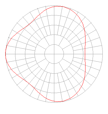 | ||||||||||||||||||||||||||||||||||||||||||||||||
| Azimuth | Ratio | Azimuth | Ratio | Azimuth | Ratio | Azimuth | Ratio | ||||||||||||||||||||||||||||||||||||||||||
| 0 | 0.974 | 10 | 0.990 | 20 | 0.974 | 30 | 0.935 | ||||||||||||||||||||||||||||||||||||||||||
| 40 | 0.878 | 50 | 0.811 | 60 | 0.741 | 70 | 0.684 | ||||||||||||||||||||||||||||||||||||||||||
| 80 | 0.650 | 90 | 0.639 | 100 | 0.650 | 110 | 0.684 | ||||||||||||||||||||||||||||||||||||||||||
| 120 | 0.741 | 130 | 0.811 | 140 | 0.878 | 150 | 0.935 | ||||||||||||||||||||||||||||||||||||||||||
| 160 | 0.974 | 170 | 0.990 | 180 | 0.974 | 190 | 0.928 | ||||||||||||||||||||||||||||||||||||||||||
| 200 | 0.867 | 210 | 0.816 | 220 | 0.797 | 230 | 0.818 | ||||||||||||||||||||||||||||||||||||||||||
| 240 | 0.870 | 250 | 0.932 | 260 | 0.981 | 270 | 1.000 | ||||||||||||||||||||||||||||||||||||||||||
| 280 | 0.981 | 290 | 0.932 | 300 | 0.870 | 310 | 0.818 | ||||||||||||||||||||||||||||||||||||||||||
| 320 | 0.797 | 330 | 0.816 | 340 | 0.867 | 350 | 0.928 | ||||||||||||||||||||||||||||||||||||||||||
Structure Registration Number 1010985 Structure Type: TOWER Registered To: KTUL Licensee, LLC Structure Address: 13455 S 321st E Ave Coweta, OK County Name: Wagoner County ASR Issued: 01/11/2017 Date Built: 01/01/1988 Site Elevation: 196 m (643 ft.) Structure Height: 551.3 m (1809 ft.) Height Overall: 581.8 m (1909 ft.) Overall Height AMSL: 777.8 m (2552 ft.) Paint & Light FAA Chapters: 1, 3, 10.2, 19.2, 21 35-58-08.0 N 95-36-56.0 W (NAD 83) 35-58-07.6 N 95-36-55.1 W (Converted to NAD 27) |
Pillsbury Winthrop Shaw Pittman Llp 1200 Seventeenth Street, Nw Washington, MD 20036 Phone: 202-663-8195 Limited Liability Company | Title: Cfo Date: 05/31/2023 Application Certifier KTUL Licensee, LLC Ktul Licensee, Llc 10706 Beaver Dam Road Cockeysville, MD 21030 Applicant Paul A. Cicelski, Esq Lerman Senter Pllc 2001 L. Street Nw Suite 400 Washington, DC 20036 Legal Representative John E. Hidle, PE Carl T. Jones Corporation 7901 Yarnwood Court Springfield, VA 22153 Consulting Engineer | |||||||||||||||||||||||||||||||||||||||||||||||
|
| ||||||||||||||||||||||||||||||||||||||||||||||||