
FCCInfo.com
A Service of Cavell, Mertz & Associates, Inc.
(855) FCC-INFO
|
|
K24JE-D from 08/03/1981 |
|
|
||||||||||||||||
|
|
Status: License Application Accepted: 06/09/2023 License Expires: 02/01/2023 File Number: -0000216479 FCC Website Links: LMS Facility Details This Application Other K24JE-D Applications Including Superseded Applications Mailing Address Correspondence for K24JE-D Correspondence related to application -0000216479 Service Contour - Open Street Map or USGS Map (51 dBu) Service Contour - KML / Google Earth (51 dBu) Rabbit Ears Info Search for K24JE-D Site Location: 43-52-24.4 N 121-30-15.1 W (NAD 83) Site Location: 43-52-25.0 N 121-30-11.0 W (Converted to NAD 27) ERP: 0.36 kW Polarization: Horizontally polarized R/C AGL: 15 m (49 ft.) R/C AMSL: 1516.1 m (4974 ft.) Emission Mask: Stringent Site Elevation: 1501.1 m. (4925 ft.) Height Overall*: 16.8 m (55 ft.) (* As Filed In This Application, may differ from ASR Data, Below.) Directional Antenna - Antenna Make/Model: Kathrein 1x2 750 10210 Array Antenna ID: 1010800 Polarization: Horizontally polarized
| ||||||||||||||||||
| Antenna Data for Antenna Id: 1010800 K24JE-D LD File: -0000216479 Kathrein - 1x2 750 10210 Array Service: LD Standard Pattern: N Pattern and Field Values Include a 100° Clockwise Rotation | 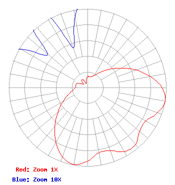 | ||||||||||||||||||
| Azimuth | Ratio | Azimuth | Ratio | Azimuth | Ratio | Azimuth | Ratio | ||||||||||||
| 0 | 0.136 | 10 | 0.141 | 20 | 0.144 | 30 | 0.183 | ||||||||||||
| 40 | 0.251 | 50 | 0.359 | 60 | 0.493 | 70 | 0.650 | ||||||||||||
| 80 | 0.807 | 90 | 0.945 | 100 | 1.000 | 110 | 0.945 | ||||||||||||
| 120 | 0.853 | 130 | 0.864 | 140 | 0.947 | 150 | 0.939 | ||||||||||||
| 160 | 0.854 | 170 | 0.841 | 180 | 0.935 | 190 | 0.991 | ||||||||||||
| 200 | 0.936 | 210 | 0.801 | 220 | 0.647 | 230 | 0.489 | ||||||||||||
| 240 | 0.358 | 250 | 0.256 | 260 | 0.188 | 270 | 0.154 | ||||||||||||
| 280 | 0.151 | 290 | 0.145 | 300 | 0.097 | 310 | 0.066 | ||||||||||||
| 320 | 0.118 | 330 | 0.112 | 340 | 0.054 | 350 | 0.091 | ||||||||||||
Structure Registration Number 1249718 Structure Type: POLE Registered To: NPG of Oregon, Inc. Structure Address: Spring River Butte Sunriver, OR County Name: Deschutes County ASR Issued: 05/11/2015 Date Built: 01/01/1980 Site Elevation: 1501.1 m (4925 ft.) Structure Height: 16.8 m (55 ft.) Height Overall: 16.8 m (55 ft.) Overall Height AMSL: 1517.9 m (4980 ft.) FAA Determination: 08/09/2005 FAA Study #: 2005-ANM-1376-OE Paint & Light FAA Chapters: NONE 43-52-24.4 N 121-30-15.1 W (NAD 83) 43-52-25.0 N 121-30-11.0 W (Converted to NAD 27) |
825 Edmond Street St. Joseph, MO 64501 Phone: 816-271-8505 Corporation | Title: Evp And Cfo Of Parent, Npgco Date: 06/09/2023 Application Certifier NPG of Oregon, Inc. Npg Of Oregon, Inc. 825 Edmond Street St. Joseph, MO 64501 Applicant Elizabeth E. Spainhour Brooks, Pierce Et Al. 150 Fayetteville Street Suite 1700 Raleigh, NC 27601 Louis R duTreil, Jr Dutreil Lundin & Rackley Inc 5212 Station Way Sarasota, FL 34233 Technical Consultant | |||||||||||||||||