
FCCInfo.com
A Service of Cavell, Mertz & Associates, Inc.
(855) FCC-INFO
|
|
K20OL-D from 06/02/2010 |
|
|
||||||||||||||||
|
|
Status: License Application Accepted: 06/30/2023 License Expires: 06/01/2029 File Number: -0000217458 FCC Website Links: LMS Facility Details This Application Other K20OL-D Applications Including Superseded Applications Mailing Address Correspondence for K20OL-D Correspondence related to application -0000217458 Service Contour - Open Street Map or USGS Map (51 dBu) Service Contour - KML / Google Earth (51 dBu) Rabbit Ears Info Search for K20OL-D Site Location: 35-26-51.3 N 94-21-54.8 W (NAD 83) Site Location: 35-26-51.0 N 94-21-54.0 W (Converted to NAD 27) ERP: 15 kW Polarization: Horizontally polarized Electrical Beam Tilt: .75 degrees R/C AGL: 53.7 m (176 ft.) R/C AMSL: 300.6 m (986 ft.) Emission Mask: Full Service Site Elevation: 246.9 m. (810 ft.) Height Overall*: 95.4 m (313 ft.) (* As Filed In This Application, may differ from ASR Data, Below.) Directional Antenna - Antenna Make/Model: Propagation System Inc PSILPD801-20/22/25 Antenna ID: 1010637 Polarization: Horizontally polarized | ||||||||||||||||||
| Antenna Data for Antenna Id: 1010637 K20OL-D LD File: -0000217458 Propagation System Inc - PSILPD801-20/22/25 Service: LD Standard Pattern: N Pattern and Field Values Include a 180.0° Clockwise Rotation | 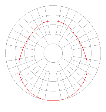 | ||||||||||||||||||
| Azimuth | Ratio | Azimuth | Ratio | Azimuth | Ratio | Azimuth | Ratio | ||||||||||||
| 0 | 0.670 | 10 | 0.670 | 20 | 0.660 | 30 | 0.640 | ||||||||||||
| 40 | 0.620 | 50 | 0.600 | 60 | 0.600 | 70 | 0.610 | ||||||||||||
| 80 | 0.630 | 90 | 0.660 | 100 | 0.710 | 110 | 0.760 | ||||||||||||
| 120 | 0.820 | 130 | 0.870 | 140 | 0.910 | 150 | 0.950 | ||||||||||||
| 160 | 0.980 | 170 | 1.000 | 180 | 1.000 | 190 | 1.000 | ||||||||||||
| 200 | 0.980 | 210 | 0.950 | 220 | 0.910 | 230 | 0.870 | ||||||||||||
| 240 | 0.820 | 250 | 0.760 | 260 | 0.710 | 270 | 0.660 | ||||||||||||
| 280 | 0.630 | 290 | 0.610 | 300 | 0.600 | 310 | 0.600 | ||||||||||||
| 320 | 0.620 | 330 | 0.640 | 340 | 0.660 | 350 | 0.670 | ||||||||||||
Structure Registration Number 1236377 Structure Type: TOWER Registered To: American Towers LLC Structure Address: Pernot Road Van Burent, AR County Name: Crawford County ASR Issued: 01/05/2021 Date Built: 10/31/2003 Site Elevation: 246.9 m (810 ft.) Structure Height: 94.5 m (310 ft.) Height Overall: 95.4 m (313 ft.) Overall Height AMSL: 342.3 m (1123 ft.) FAA Determination: 10/11/2002 FAA Study #: 2002-ASW-4081-OE FAA Circular #: 70/7460-1K Paint & Light FAA Chapters: 4, 8, 12 Removed expiration date from determination. Scenario 1./jjs/case#635066 35-26-51.3 N 94-21-54.8 W (NAD 83) 35-26-51.0 N 94-21-54.0 W (Converted to NAD 27) |
Little Rock, AR 72221 Phone: 501-500-0130 Limited Liability Company | Title: Manager Date: 06/30/2023 Application Certifier KTV MEDIA Ktv Media, Llc Little Rock, AR 72221 Applicant Jim McPhetridge Jim Mcphetridge 104 Woodmont Montgomery, TX 77356 Broadcast Engineer LARRY MORTON Ktv Media, Llc Little Rock, AR 72221 MANAGER | |||||||||||||||||