
FCCInfo.com
A Service of Cavell, Mertz & Associates, Inc.
(855) FCC-INFO
|
|
WTZP-LD from 01/13/2009 WTZP-LD from 11/07/2008 WTZP-LD from 06/23/1998 WTZP-LD from 11/14/1986 |
|
|
||||||||||||||||
|
|
Status: License Application Accepted: 07/14/2023 License Expires: 10/01/2029 File Number: -0000217943 FCC Website Links: LMS Facility Details This Application Other WTZP-LD Applications Including Superseded Applications Mailing Address Correspondence for WTZP-LD Correspondence related to application -0000217943 Service Contour - Open Street Map or USGS Map (51 dBu) Service Contour - KML / Google Earth (51 dBu) Rabbit Ears Info Search for WTZP-LD Site Location: 38-43-21.5 N 83-00-05.1 W (NAD 83) Site Location: 38-43-21.2 N 83-00-05.5 W (Converted to NAD 27) ERP: 15 kW Polarization: Horizontally polarized Electrical Beam Tilt: 1.0 degree R/C AGL: 45.7 m (150 ft.) R/C AMSL: 383.4 m (1258 ft.) Emission Mask: Full Service Site Elevation: 337.7 m. (1108 ft.) Height Overall*: 82.6 m (271 ft.) (* As Filed In This Application, may differ from ASR Data, Below.) Directional Antenna - Antenna Make/Model: Dielectric TLP-8E Antenna ID: 1009235 Polarization: Horizontally polarized | ||||||||||||||||||
| Antenna Data for Antenna Id: 1009235 WTZP-LD LD File: -0000217943 Dielectric - TLP-8E Service: LD Standard Pattern: Y | 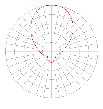 | ||||||||||||||||||
| Azimuth | Ratio | Azimuth | Ratio | Azimuth | Ratio | Azimuth | Ratio | ||||||||||||
| 0 | 1.000 | 10 | 0.995 | 20 | 0.945 | 30 | 0.848 | ||||||||||||
| 40 | 0.725 | 50 | 0.590 | 60 | 0.457 | 70 | 0.346 | ||||||||||||
| 80 | 0.277 | 90 | 0.231 | 100 | 0.195 | 110 | 0.162 | ||||||||||||
| 120 | 0.137 | 130 | 0.127 | 140 | 0.139 | 150 | 0.166 | ||||||||||||
| 160 | 0.198 | 170 | 0.225 | 180 | 0.240 | 190 | 0.226 | ||||||||||||
| 200 | 0.197 | 210 | 0.164 | 220 | 0.136 | 230 | 0.128 | ||||||||||||
| 240 | 0.153 | 250 | 0.190 | 260 | 0.222 | 270 | 0.254 | ||||||||||||
| 280 | 0.301 | 290 | 0.369 | 300 | 0.459 | 310 | 0.570 | ||||||||||||
| 320 | 0.693 | 330 | 0.820 | 340 | 0.928 | 350 | 0.988 | ||||||||||||
Structure Registration Number 1043740 Structure Type: GTOWER Registered To: Hemry Radio Engineering LLC Structure Address: 0.5 Mi S Of Portsmouth Oh Southshore, KY County Name: Greenup County ASR Issued: 06/02/2021 Date Built: 01/01/1987 Site Elevation: 337.7 m (1108 ft.) Structure Height: 81.6 m (268 ft.) Height Overall: 82.6 m (271 ft.) Overall Height AMSL: 420.3 m (1379 ft.) FAA Determination: 01/25/2013 FAA Study #: 2012-ASO-11085-OE Paint & Light FAA Chapters: 1, 3, 11, 21 Continue As Is OM&L = PAINT/RED LIGHTS 38-43-21.5 N 83-00-05.1 W (NAD 83) 38-43-21.2 N 83-00-05.5 W (Converted to NAD 27) |
227e. Main St P.o. Box 1223 Portsmouth, Oh 45662 Jackson, OH 45640 Phone: 740-285-2813 Corporation | Title: President Date: 07/14/2023 Application Certifier EAGLE BROADCASTING GROUP, INC. Eagle Broadcasting Group, Inc. 227e. Main St P.o. Box 1223 Portsmouth, Oh 45662 Jackson, OH 45640 Applicant Patrick Cross Brooks, Pierce Et Al. 150 Fayetteville Street Suite 1700 Raleigh, NC 27601 Fred Francis Eagle Broadcasting 1226 Lower Gragston Creek Rd. Prichard, WV 25555 Manager Scott Turpie Lohnes & Culver, Llc Alexandria, VA 22302 Sr. Technical Consultant | |||||||||||||||||