
FCCInfo.com
A Service of Cavell, Mertz & Associates, Inc.
(855) FCC-INFO
|
|
WLCN-CD from 01/19/2009 WLCN-CD from 09/12/1997 WLCN-CD from 02/26/1996 WLCN-CD from 09/02/1994 WLCN-CD from 11/09/1992 |
|  |
|
|||||||||||||||
|
|
Repacking Information: No changes Status: License Application Accepted: 08/23/2023 License Expires: 12/01/2028 File Number: -0000219781 FCC Website Links: LMS Facility Details This Application Other WLCN-CD Applications Including Superseded Applications Mailing Address Correspondence for WLCN-CD Correspondence related to application -0000219781 Service Contour - Open Street Map or USGS Map (51 dBu) Service Contour - KML / Google Earth (51 dBu) Public Inspection Files Rabbit Ears Info Search for WLCN-CD Site Location: 32-49-05.0 N 79-50-07.0 W (NAD 83) Site Location: 32-49-04.4 N 79-50-07.7 W (Converted to NAD 27) ERP: 15 kW Polarization: Elliptically polarized Electrical Beam Tilt: 1 degree R/C AGL: 182.9 m (600 ft.) R/C AMSL: 187.2 m (614 ft.) Emission Mask: Simple Site Elevation: 4.3 m. (14 ft.) Height Overall*: 249.9 m (820 ft.) (* As Filed In This Application, may differ from ASR Data, Below.) Directional Antenna - Antenna Make/Model: DIELECTRIC TLP-12W/VP Antenna ID: 1011023 Polarization: Elliptically polarized | ||||||||||||||||||
| Antenna Data for Antenna Id: 1011023 WLCN-CD DC File: -0000219781 DIELECTRIC - TLP-12W/VP Service: DC Standard Pattern: N Pattern and Field Values Include a 320° Clockwise Rotation | 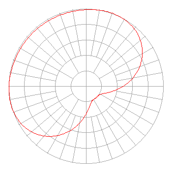 | ||||||||||||||||||
| Azimuth | Ratio | Azimuth | Ratio | Azimuth | Ratio | Azimuth | Ratio | ||||||||||||
| 0 | 0.986 | 10 | 0.995 | 20 | 1.000 | 30 | 0.993 | ||||||||||||
| 40 | 0.968 | 50 | 0.918 | 60 | 0.841 | 70 | 0.739 | ||||||||||||
| 80 | 0.617 | 90 | 0.488 | 100 | 0.365 | 110 | 0.268 | ||||||||||||
| 120 | 0.214 | 130 | 0.199 | 140 | 0.199 | 150 | 0.199 | ||||||||||||
| 160 | 0.214 | 170 | 0.268 | 180 | 0.365 | 190 | 0.488 | ||||||||||||
| 200 | 0.617 | 210 | 0.739 | 220 | 0.841 | 230 | 0.918 | ||||||||||||
| 240 | 0.968 | 250 | 0.993 | 260 | 1.000 | 270 | 0.995 | ||||||||||||
| 280 | 0.986 | 290 | 0.978 | 300 | 0.974 | 310 | 0.972 | ||||||||||||
| 320 | 0.972 | 330 | 0.972 | 340 | 0.974 | 350 | 0.978 | ||||||||||||
Structure Registration Number 1024868 Structure Type: TOWER Registered To: Vertical Bridge CC FM, LLC Structure Address: 1 Km E Int Us 17 & Hwy 701 Mount Pleasant, SC County Name: Charleston County ASR Issued: 11/08/2018 Date Built: 09/07/1997 Site Elevation: 4.3 m (14 ft.) Structure Height: 249.9 m (820 ft.) Height Overall: 249.9 m (820 ft.) Overall Height AMSL: 254.2 m (834 ft.) FAA Determination: 07/23/1997 FAA Study #: 96-ASO-0045-OE FAA Circular #: 70/7460-1J Paint & Light FAA Chapters: 4, 5, 6, 8, 13 32-49-05.0 N 79-50-07.0 W (NAD 83) 32-49-04.4 N 79-50-07.7 W (Converted to NAD 27) |
Clearwater, FL 33758 Phone: 727-535-5622 Not-for-Profit | Title: President Date: 08/23/2023 Application Certifier Christian Television Network Of South Carolina, Inc. Clearwater, FL 33758 Applicant Joseph C Chautin, III Hardy, Carey, Chautin & Balkin, Llp 1080 West Causeway Approach Mandeville, LA 70471 Legal Counsel | |||||||||||||||||