
FCCInfo.com
A Service of Cavell, Mertz & Associates, Inc.
(855) FCC-INFO
|
|
K22MT-D from 09/19/2018 K22MT-D from 02/16/2010 |
|
|
|||||||||||||||||
|
|
Status: License Application Accepted: 09/19/2023 License Expires: 06/01/2030 File Number: -0000221138 FCC Website Links: LMS Facility Details This Application Other K22MT-D Applications Including Superseded Applications Mailing Address Correspondence for K22MT-D Correspondence related to application -0000221138 Service Contour - Open Street Map or USGS Map (51 dBu) Service Contour - KML / Google Earth (51 dBu) Rabbit Ears Info Search for K22MT-D Site Location: 34-02-57.3 N 94-44-10.2 W (NAD 83) Site Location: 34-02-56.9 N 94-44-09.4 W (Converted to NAD 27) ERP: 9.5 kW Polarization: Horizontally polarized Electrical Beam Tilt: 1.0 degree R/C AGL: 81 m (266 ft.) R/C AMSL: 229.7 m (754 ft.) Emission Mask: Full Service Site Elevation: 148.7 m. (488 ft.) Height Overall*: 96 m (315 ft.) (* As Filed In This Application, may differ from ASR Data, Below.) Directional Antenna - Antenna Make/Model: DIELECTRIC DLP-8C Antenna ID: 1011101 Polarization: Horizontally polarized
| |||||||||||||||||||
| Antenna Data for Antenna Id: 1011101 K22MT-D LD File: -0000221138 DIELECTRIC - DLP-8C Service: LD Standard Pattern: N Pattern and Field Values Include a 225° Clockwise Rotation | 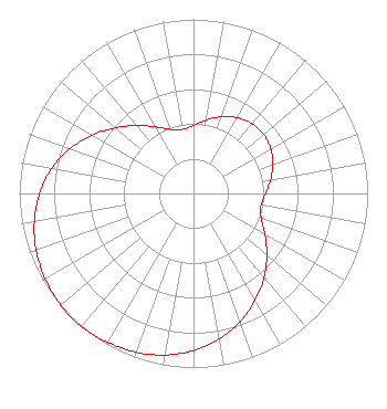 | |||||||||||||||||||
| Azimuth | Ratio | Azimuth | Ratio | Azimuth | Ratio | Azimuth | Ratio | |||||||||||||
| 5 | 0.408 | 15 | 0.449 | 25 | 0.487 | 35 | 0.515 | |||||||||||||
| 45 | 0.527 | 55 | 0.522 | 65 | 0.500 | 71 | 0.481 | |||||||||||||
| 75 | 0.467 | 85 | 0.430 | 95 | 0.400 | 105 | 0.398 | |||||||||||||
| 115 | 0.440 | 125 | 0.510 | 135 | 0.590 | 145 | 0.671 | |||||||||||||
| 155 | 0.748 | 165 | 0.818 | 175 | 0.877 | 185 | 0.924 | |||||||||||||
| 195 | 0.958 | 205 | 0.980 | 215 | 0.994 | 225 | 1.000 | |||||||||||||
| 235 | 0.990 | 245 | 0.973 | 255 | 0.946 | 265 | 0.907 | |||||||||||||
| 275 | 0.857 | 285 | 0.792 | 295 | 0.713 | 305 | 0.628 | |||||||||||||
| 315 | 0.547 | 325 | 0.474 | 335 | 0.414 | 345 | 0.378 | |||||||||||||
| 355 | 0.378 | |||||||||||||||||||
Structure Registration Number 1313116 Structure Type: LTOWER Registered To: Oklahoma Department of Transportation ITS/Wireless and Radio Comms Branch Structure Address: 1938 North Us Hwy 259 Broken Bow, OK County Name: McCurtain County ASR Issued: 04/18/2024 Date Built: 04/17/2024 Site Elevation: 148.7 m (488 ft.) Structure Height: 91.4 m (300 ft.) Height Overall: 96 m (315 ft.) Overall Height AMSL: 244.7 m (803 ft.) FAA Determination: 08/29/2019 FAA Study #: 2019-ASW-9909-OE FAA Circular #: 70/7460-1L Paint & Light FAA Chapters: 4, 8, 12 34-02-57.3 N 94-44-10.2 W (NAD 83) 34-02-56.9 N 94-44-09.4 W (Converted to NAD 27) |
7403 North Kelley Avenue Oklahoma City, OK 73113 Phone: 405-841-9250 Government Entity | Title: Executive Director Date: 09/19/2023 Application Certifier Oklahoma Educational Television Authority 7403 North Kelley Avenue Oklahoma City, OK 73113 Applicant Barry S. Persh Gray Miller Persh Llp 2233 Wisconsin Ave., Nw Suite 226 Washington, DC 20007 | ||||||||||||||||||