
FCCInfo.com
A Service of Cavell, Mertz & Associates, Inc.
(855) FCC-INFO
|
|
K30RA-D from 10/02/2012 |
|
|
||||||||||||||||
|
|
Status: Construction Permit Application Accepted: 09/15/2023 K30RA-D CP Expires: 10/28/2025 File Number: -0000221024 FCC Website Links: LMS Facility Details This Application Other K30RA-D Applications Including Superseded Applications Mailing Address Correspondence for K30RA-D Correspondence related to application -0000221024 Service Contour - Open Street Map or USGS Map (51 dBu) Service Contour - KML / Google Earth (51 dBu) Rabbit Ears Info Search for K30RA-D Site Location: 43-42-56.9 N 92-41-24.0 W (NAD 83) Site Location: 43-42-57.0 N 92-41-23.3 W (Converted to NAD 27) ERP: 1.3 kW Polarization: Horizontally polarized R/C AGL: 45.7 m (150 ft.) R/C AMSL: 473.3 m (1553 ft.) Emission Mask: Full Service Site Elevation: 427.6 m. (1403 ft.) Height Overall*: 93 m (305 ft.) (* As Filed In This Application, may differ from ASR Data, Below.) Directional Antenna - Antenna Make/Model: Kathrein 1x K723147 Antenna ID: 1008960 Polarization: Horizontally polarized | ||||||||||||||||||
| Antenna Data for Antenna Id: 1008960 K30RA-D LD File: -0000221024 Kathrein - 1x K723147 Service: LD Standard Pattern: Y Pattern and Field Values Include a 40° Clockwise Rotation | 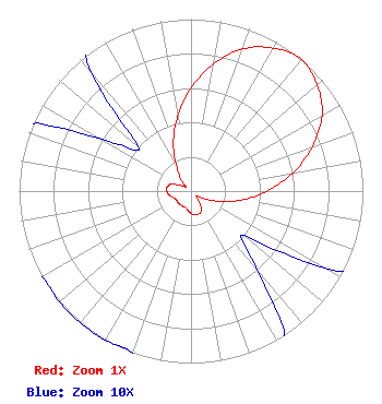 | ||||||||||||||||||
| Azimuth | Ratio | Azimuth | Ratio | Azimuth | Ratio | Azimuth | Ratio | ||||||||||||
| 0 | 0.600 | 10 | 0.750 | 20 | 0.880 | 30 | 0.960 | ||||||||||||
| 40 | 1.000 | 50 | 0.960 | 60 | 0.880 | 70 | 0.750 | ||||||||||||
| 80 | 0.600 | 90 | 0.440 | 100 | 0.300 | 110 | 0.170 | ||||||||||||
| 120 | 0.090 | 130 | 0.040 | 140 | 0.060 | 150 | 0.120 | ||||||||||||
| 160 | 0.140 | 170 | 0.140 | 180 | 0.130 | 190 | 0.110 | ||||||||||||
| 200 | 0.100 | 210 | 0.100 | 220 | 0.100 | 230 | 0.100 | ||||||||||||
| 240 | 0.100 | 250 | 0.110 | 260 | 0.130 | 270 | 0.140 | ||||||||||||
| 280 | 0.140 | 290 | 0.120 | 300 | 0.060 | 310 | 0.040 | ||||||||||||
| 320 | 0.090 | 330 | 0.170 | 340 | 0.300 | 350 | 0.440 | ||||||||||||
Structure Registration Number 1220639 Structure Type: GTOWER Registered To: American Towers LLC Structure Address: 24913 -- 680th Ave. (dexter 009305) Dexter, MN County Name: Mower County ASR Issued: 02/01/2013 Date Built: 12/13/2000 Site Elevation: 427.6 m (1403 ft.) Structure Height: 91.7 m (301 ft.) Height Overall: 93 m (305 ft.) Overall Height AMSL: 520.6 m (1708 ft.) FAA Determination: 12/05/2002 FAA Study #: 2002-AGL-6236-OE FAA Circular #: 70/7460-1J Paint & Light FAA Chapters: 4, 8, 13 PRIOR STUDY 2002-AGL-732-OE 43-42-56.9 N 92-41-24.0 W (NAD 83) 43-42-57.0 N 92-41-23.3 W (Converted to NAD 27) |
4370 Peachtree Road, Ne Atlanta, GA 30319 Phone: 404-266-8333 Limited Liability Company | Title: Assistant Secretary Date: 09/15/2023 Application Certifier Gray Television Licensee, Llc 4370 Peachtree Road, Ne Atlanta, GA 30319 Applicant Joseph M. Davis, P.E. Chesapeake Rf Consultants, Llc 207 Old Dominion Road Yorktown, VA 23692 Consulting Engineer Joan Stewart Wiley Rein Llp 2050 M Street, Nw Washington, DC 20036 | |||||||||||||||||