
FCCInfo.com
A Service of Cavell, Mertz & Associates, Inc.
(855) FCC-INFO
|
|
WIVM-LD from 05/18/2001 WIVM-LD from 07/05/1995 |
|
|
|||||||||||||||||||
|
|
Status: License Application Accepted: 09/26/2023 License Expires: 10/01/2029 File Number: -0000221449 FCC Website Links: LMS Facility Details This Application Other WIVM-LD Applications Including Superseded Applications Mailing Address Correspondence for WIVM-LD Correspondence related to application -0000221449 Service Contour - Open Street Map or USGS Map (51 dBu) Service Contour - KML / Google Earth (51 dBu) Rabbit Ears Info Search for WIVM-LD Site Location: 40-59-06.0 N 81-41-34.0 W (NAD 83) Site Location: 40-59-05.8 N 81-41-34.5 W (Converted to NAD 27) ERP: 1.5 kW Polarization: Elliptically polarized Electrical Beam Tilt: 0.50 degrees R/C AGL: 80 m (262 ft.) R/C AMSL: 460.4 m (1510 ft.) Emission Mask: Full Service Site Elevation: 380.4 m. (1248 ft.) Height Overall*: 81.7 m (268 ft.) (* As Filed In This Application, may differ from ASR Data, Below.) Directional Antenna - Antenna Make/Model: Propagation System Inc PSILP8OI-34 Antenna ID: 1005873 Polarization: Elliptically polarized | |||||||||||||||||||||
| Antenna Data for Antenna Id: 1005873 WIVM-LD LD File: -0000221449 Propagation System Inc - PSILP8OI-34 Service: LD Standard Pattern: Y Pattern and Field Values Include a 20° Clockwise Rotation | 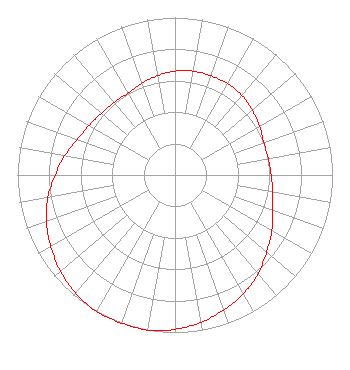 | |||||||||||||||||||||
| Azimuth | Ratio | Azimuth | Ratio | Azimuth | Ratio | Azimuth | Ratio | |||||||||||||||
| 0 | 0.660 | 10 | 0.670 | 20 | 0.670 | 30 | 0.670 | |||||||||||||||
| 40 | 0.660 | 50 | 0.640 | 60 | 0.620 | 70 | 0.600 | |||||||||||||||
| 80 | 0.600 | 90 | 0.610 | 100 | 0.630 | 110 | 0.660 | |||||||||||||||
| 120 | 0.710 | 130 | 0.760 | 140 | 0.820 | 150 | 0.870 | |||||||||||||||
| 160 | 0.910 | 170 | 0.950 | 180 | 0.980 | 190 | 1.000 | |||||||||||||||
| 200 | 1.000 | 210 | 1.000 | 220 | 0.980 | 230 | 0.950 | |||||||||||||||
| 240 | 0.910 | 250 | 0.870 | 260 | 0.820 | 270 | 0.760 | |||||||||||||||
| 280 | 0.710 | 290 | 0.660 | 300 | 0.630 | 310 | 0.610 | |||||||||||||||
| 320 | 0.600 | 330 | 0.600 | 340 | 0.620 | 350 | 0.640 | |||||||||||||||
Structure Registration Number 1050163 Structure Type: Registered To: BAKER TOWER INC. Structure Address: 1 Mile N Of Doylestown, OH County Name: Wayne County ASR Issued: 02/02/2016 Date Built: 06/24/1997 Site Elevation: 380.4 m (1248 ft.) Structure Height: 81.7 m (268 ft.) Height Overall: 81.7 m (268 ft.) Overall Height AMSL: 462.1 m (1516 ft.) FAA Determination: 01/14/1997 FAA Study #: 96-AGL-4262-OE FAA Circular #: 70/7460-1J Paint & Light FAA Chapters: 4, 6, 13 40-59-06.0 N 81-41-34.0 W (NAD 83) 40-59-05.8 N 81-41-34.5 W (Converted to NAD 27) |
6755 Freedom Ave., N.w. North Canton, OH 44720 Phone: 330-494-9303 Individual | Title: President Date: 09/26/2023 Application Certifier Wivm-ld Tv Station 6755 Freedom Ave., N.w. North Canton, OH 44720 Applicant Darryl K DeLawder Delawder Communications, Inc. P. O. Box 1095 Ashburn, VA 20146 President KATHLEEN VICTORY Fletcher, Heald & Hildreth, P.l.c. 1300 N 17th Street, 11th Floor Arlington, VA 22209 FCC COUNSEL | ||||||||||||||||||||
| ||||||||||||||||||||||