
FCCInfo.com
A Service of Cavell, Mertz & Associates, Inc.
(855) FCC-INFO
|
|
|
RF spectrum relinquished in the spectrum auction Virtual Channel 42 |
|
||||||||||||||||||||||||||||||||||
|
|
WVPY is a channel sharing guest of WVPT, Staunton, Virginia Repacking Information: Channel 21 was relinquished in the spectrum auction Status: License Application Accepted: 09/25/2023 License Expires: 10/01/2028 File Number: -0000221338 FCC Website Links: LMS Facility Details This Application Other WVPY Applications Including Superseded Applications Mailing Address Correspondence for WVPY Correspondence related to application -0000221338 Service Contour - Open Street Map or USGS Map (41 dBu) Service Contour - KML / Google Earth (41 dBu) Public Inspection Files Rabbit Ears Info Search for WVPY DTS Site Number: 2 Site Location: 37-59-00.0 N 78-29-01.0 W (NAD 83) Site Location: 37-58-59.5 N 78-29-02.0 W (Converted to NAD 27) ERP: 15 kW Polarization: Elliptically polarized HAAT: 333 m (1093 ft.) R/C AGL: 66 m (217 ft.) R/C AMSL: 493.1 m (1618 ft.) Site Elevation: 427.1 m. (1401 ft.) Height Overall*: 90.5 m (297 ft.) (* As Filed In This Application, may differ from ASR Data, Below.) Directional Antenna - Antenna Make/Model: Dielectric TUL-BP2-1/2M-1-K Antenna ID: 1011089 Polarization: Elliptically polarized | ||||||||||||||||||||||||||||||||||||
| Antenna Data for Antenna Id: 1011089 WVPY DD File: -0000221338 Dielectric - TUL-BP2-1/2M-1-K Service: DD Standard Pattern: N | 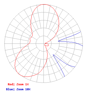 | ||||||||||||||||||||||||||||||||||||
| Azimuth | Ratio | Azimuth | Ratio | Azimuth | Ratio | Azimuth | Ratio | ||||||||||||||||||||||||||||||
| 0 | 1.000 | 10 | 0.973 | 20 | 0.882 | 30 | 0.755 | ||||||||||||||||||||||||||||||
| 40 | 0.609 | 50 | 0.449 | 60 | 0.285 | 70 | 0.133 | ||||||||||||||||||||||||||||||
| 80 | 0.039 | 90 | 0.087 | 100 | 0.123 | 110 | 0.135 | ||||||||||||||||||||||||||||||
| 120 | 0.123 | 130 | 0.087 | 140 | 0.039 | 150 | 0.133 | ||||||||||||||||||||||||||||||
| 160 | 0.285 | 170 | 0.449 | 180 | 0.609 | 190 | 0.775 | ||||||||||||||||||||||||||||||
| 200 | 0.882 | 210 | 0.973 | 220 | 0.999 | 230 | 0.947 | ||||||||||||||||||||||||||||||
| 240 | 0.816 | 250 | 0.648 | 260 | 0.487 | 270 | 0.369 | ||||||||||||||||||||||||||||||
| 280 | 0.346 | 290 | 0.368 | 300 | 0.346 | 310 | 0.369 | ||||||||||||||||||||||||||||||
| 320 | 0.487 | 330 | 0.648 | 340 | 0.816 | 350 | 0.947 | ||||||||||||||||||||||||||||||
Structure Registration Number 1018222 Structure Type: GTOWER Registered To: VPM Media Corporation Structure Address: Carters Mountain 3.1 Mi S Charlottesville, VA County Name: Albemarle County ASR Issued: 06/18/2020 Date Built: 06/15/2019 Site Elevation: 427.1 m (1401 ft.) Structure Height: 81.7 m (268 ft.) Height Overall: 90.5 m (297 ft.) Overall Height AMSL: 517.6 m (1698 ft.) FAA Determination: 05/06/2019 FAA Study #: 2019-AEA-5099-OE FAA Circular #: 70/7460-1L Paint & Light FAA Chapters: 4, 8, 12 PRIOR STUDY 1997-AEA-898-OE 37-59-00.0 N 78-29-01.0 W (NAD 83) 37-58-59.5 N 78-29-02.0 W (Converted to NAD 27) |
23 Sesame Street Richmond, VA 23235 Phone: 804-320-1301 Limited Liability Company | Application Certifier COMMONWEALTH PUBLIC BROADCASTING CORPORATION Commonwealth Public Broadcasting Corporation 23 Sesame Street Richmond, VA 23235 Applicant Ari Meltzer Wiley Rein Llp 1776 K Street, Nw Washington, DC 20006 | |||||||||||||||||||||||||||||||||||
| |||||||||||||||||||||||||||||||||||||