
FCCInfo.com
A Service of Cavell, Mertz & Associates, Inc.
(855) FCC-INFO
|
|
|
RF spectrum relinquished in the spectrum auction Virtual Channel 42 |
|
||||||||||||||||||||||||||||||||||
|
|
WVPY is a channel sharing guest of WVPT, Staunton, Virginia Repacking Information: Channel 21 was relinquished in the spectrum auction Status: License Application Accepted: 09/25/2023 License Expires: 10/01/2028 File Number: -0000221338 FCC Website Links: LMS Facility Details This Application Other WVPY Applications Including Superseded Applications Mailing Address Correspondence for WVPY Correspondence related to application -0000221338 Service Contour - Open Street Map or USGS Map (41 dBu) Service Contour - KML / Google Earth (41 dBu) Public Inspection Files Rabbit Ears Info Search for WVPY DTS Site Number: 3 Site Location: 38-36-03.9 N 78-37-56.8 W (NAD 83) Site Location: 38-36-03.5 N 78-37-57.7 W (Converted to NAD 27) ERP: 0.1 kW Polarization: Horizontally polarized HAAT: 583.84 m (1915 ft.) R/C AGL: 59.1 m (194 ft.) R/C AMSL: 962.1 m (3156 ft.) Site Elevation: 903 m. (2963 ft.) Height Overall*: 73.5 m (241 ft.) (* As Filed In This Application, may differ from ASR Data, Below.) Directional Antenna - Antenna Make/Model: Dielectric TUL-C2SP-15 COS 66_33 Antenna ID: 1011090 Polarization: Horizontally polarized | ||||||||||||||||||||||||||||||||||||
| Antenna Data for Antenna Id: 1011090 WVPY DD File: -0000221338 Dielectric - TUL-C2SP-15 COS 66_33 Service: DD Standard Pattern: N | 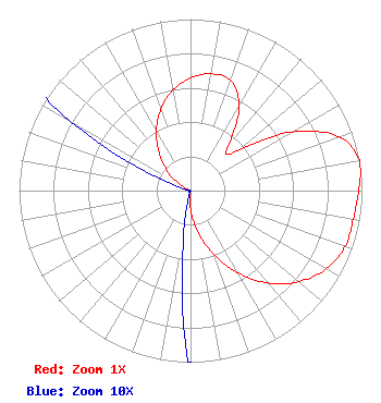 | ||||||||||||||||||||||||||||||||||||
| Azimuth | Ratio | Azimuth | Ratio | Azimuth | Ratio | Azimuth | Ratio | ||||||||||||||||||||||||||||||
| 0 | 0.657 | 10 | 0.691 | 20 | 0.684 | 30 | 0.569 | ||||||||||||||||||||||||||||||
| 40 | 0.352 | 45 | 0.300 | 50 | 0.373 | 60 | 0.683 | ||||||||||||||||||||||||||||||
| 70 | 0.920 | 80 | 1.000 | 90 | 0.981 | 100 | 0.964 | ||||||||||||||||||||||||||||||
| 110 | 0.959 | 120 | 0.913 | 130 | 0.825 | 140 | 0.702 | ||||||||||||||||||||||||||||||
| 150 | 0.554 | 160 | 0.397 | 170 | 0.243 | 180 | 0.111 | ||||||||||||||||||||||||||||||
| 190 | 0.019 | 200 | 0.001 | 210 | 0.001 | 220 | 0.001 | ||||||||||||||||||||||||||||||
| 230 | 0.001 | 240 | 0.001 | 250 | 0.001 | 260 | 0.001 | ||||||||||||||||||||||||||||||
| 270 | 0.001 | 280 | 0.001 | 290 | 0.014 | 300 | 0.080 | ||||||||||||||||||||||||||||||
| 310 | 0.175 | 320 | 0.286 | 330 | 0.399 | 340 | 0.505 | ||||||||||||||||||||||||||||||
| 350 | 0.594 | ||||||||||||||||||||||||||||||||||||
Structure Registration Number 1018206 Structure Type: GTOWER Registered To: Shenandoah Valley Electric Cooperative Structure Address: Massanutten Mountain 6.2 Km Sw Luray Luray, VA County Name: Page County ASR Issued: 01/30/2020 Date Built: 01/01/1967 Site Elevation: 903 m (2963 ft.) Structure Height: 61.3 m (201 ft.) Height Overall: 73.5 m (241 ft.) Overall Height AMSL: 976.5 m (3204 ft.) FAA Determination: 05/05/2017 FAA Study #: 2017-AEA-4446-OE FAA Circular #: 70/7460-1L Paint & Light FAA Chapters: 4, 8, 12 38-36-03.9 N 78-37-56.8 W (NAD 83) 38-36-03.5 N 78-37-57.7 W (Converted to NAD 27) |
23 Sesame Street Richmond, VA 23235 Phone: 804-320-1301 Limited Liability Company | Application Certifier COMMONWEALTH PUBLIC BROADCASTING CORPORATION Commonwealth Public Broadcasting Corporation 23 Sesame Street Richmond, VA 23235 Applicant Ari Meltzer Wiley Rein Llp 1776 K Street, Nw Washington, DC 20006 | |||||||||||||||||||||||||||||||||||
| |||||||||||||||||||||||||||||||||||||