
FCCInfo.com
A Service of Cavell, Mertz & Associates, Inc.
(855) FCC-INFO
|
|
|
|
|
||||||||||||||||
|
|
Status: Application Application Accepted: 03/04/2024 License Expires: 12/01/2030 File Number: -0000240316 FCC Website Links: LMS Facility Details This Application Other K25QM-D Applications Including Superseded Applications Mailing Address Correspondence for K25QM-D Correspondence related to application -0000240316 Service Contour - Open Street Map or USGS Map (51 dBu) Service Contour - KML / Google Earth (51 dBu) Rabbit Ears Info Search for K25QM-D Site Location: 33-52-02.9 N 116-26-01.1 W (NAD 83) Site Location: 33-52-02.8 N 116-25-58.1 W (Converted to NAD 27) ERP: 15 kW Polarization: Elliptically polarized Electrical Beam Tilt: 0.9 degrees R/C AGL: 12.1 m (40 ft.) R/C AMSL: 490 m (1608 ft.) Emission Mask: Full Service Site Elevation: 477.9 m. (1568 ft.) Height Overall*: 39.6 m (130 ft.) (* As Filed In This Application, may differ from ASR Data, Below.) Directional Antenna - Antenna Make/Model: Kathrein 3x2 750 0000049 Antenna ID: 1011528 Polarization: Elliptically polarized | ||||||||||||||||||
| Antenna Data for Antenna Id: 1011528 K25QM-D LD File: -0000240316 Kathrein - 3x2 750 0000049 Service: LD Standard Pattern: N | 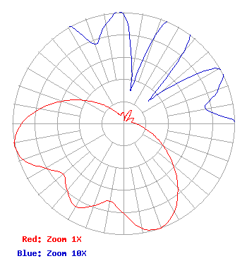 | ||||||||||||||||||
| Azimuth | Ratio | Azimuth | Ratio | Azimuth | Ratio | Azimuth | Ratio | ||||||||||||
| 0 | 0.098 | 10 | 0.044 | 13 | 0.033 | 20 | 0.085 | ||||||||||||
| 30 | 0.137 | 40 | 0.085 | 47 | 0.033 | 50 | 0.044 | ||||||||||||
| 60 | 0.099 | 70 | 0.091 | 80 | 0.075 | 90 | 0.108 | ||||||||||||
| 100 | 0.174 | 110 | 0.278 | 120 | 0.418 | 130 | 0.585 | ||||||||||||
| 140 | 0.761 | 150 | 0.915 | 160 | 0.997 | 162 | 1.000 | ||||||||||||
| 170 | 0.958 | 180 | 0.810 | 190 | 0.710 | 200 | 0.789 | ||||||||||||
| 210 | 0.861 | 220 | 0.789 | 230 | 0.710 | 240 | 0.810 | ||||||||||||
| 250 | 0.957 | 258 | 1.000 | 260 | 0.997 | 270 | 0.915 | ||||||||||||
| 280 | 0.761 | 290 | 0.585 | 300 | 0.418 | 310 | 0.278 | ||||||||||||
| 320 | 0.174 | 330 | 0.108 | 340 | 0.076 | 350 | 0.091 | ||||||||||||
Structure Registration Number 1203976 Structure Type: TOWER Registered To: American Towers LLC Structure Address: 70500 Varner Rd. (edom Hill T3 #40764) Desert Hot Springs, CA County Name: Riverside County ASR Issued: 01/15/2013 Date Built: 10/31/2000 Site Elevation: 477.9 m (1568 ft.) Structure Height: 36.6 m (120 ft.) Height Overall: 39.6 m (130 ft.) Overall Height AMSL: 517.5 m (1698 ft.) FAA Determination: 01/24/2005 FAA Study #: 2004-AWP-5735-OE Paint & Light FAA Chapters: NONE PRIOR STUDY 2004-AWP-3008-OE 33-52-02.9 N 116-26-01.1 W (NAD 83) 33-52-02.8 N 116-25-58.1 W (Converted to NAD 27) |
2383 Pruneridge Avenue Suite 4 Santa Clara, CA 95050 Phone: 415-886-7284 Corporation | Title: President Date: 03/04/2024 Application Certifier Major Market Broadcasting Of California Inc. 2383 Pruneridge Avenue Suite 4 Santa Clara, CA 95050 Applicant Ravi Kapur Major Market Broadcasting Of California Inc. 2383 Pruneridge Avenue Suite 4 Santa Clara, CA 95050 President Benjamin Pidek, P.E Ben Pidek Consulting, Llc 7670 Coventry Dr. Temperance, MI 48182 Consulting Engineer | |||||||||||||||||