
FCCInfo.com
A Service of Cavell, Mertz & Associates, Inc.
(855) FCC-INFO
|
|
W16EL-D from 02/22/2011 |
|
|
||||||||||||||||
|
|
Status: License Application Accepted: 10/10/2023 License Expires: 04/01/2029 File Number: -0000222337 FCC Website Links: LMS Facility Details This Application Other W16EL-D Applications Including Superseded Applications Mailing Address Correspondence for W16EL-D Correspondence related to application -0000222337 Service Contour - Open Street Map or USGS Map (51 dBu) Service Contour - KML / Google Earth (51 dBu) Rabbit Ears Info Search for W16EL-D Site Location: 33-36-09.7 N 81-46-46.1 W (NAD 83) Site Location: 33-36-09.2 N 81-46-46.7 W (Converted to NAD 27) ERP: 4 kW Polarization: Horizontally polarized Electrical Beam Tilt: 1.0 degree R/C AGL: 39.6 m (130 ft.) R/C AMSL: 191.4 m (628 ft.) Emission Mask: Full Service Site Elevation: 151.8 m. (498 ft.) Height Overall*: 89.9 m (295 ft.) (* As Filed In This Application, may differ from ASR Data, Below.) Directional Antenna - Antenna Make/Model: Dielectric DLP-4B Antenna ID: 1011164 Polarization: Horizontally polarized
| ||||||||||||||||||
| Antenna Data for Antenna Id: 1011164 W16EL-D LD File: -0000222337 Dielectric - DLP-4B Service: LD Standard Pattern: N Pattern and Field Values Include a 40° Clockwise Rotation | 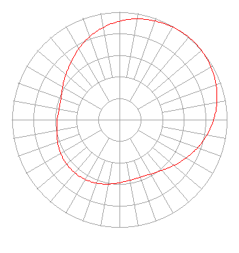 | ||||||||||||||||||
| Azimuth | Ratio | Azimuth | Ratio | Azimuth | Ratio | Azimuth | Ratio | ||||||||||||
| 0 | 0.914 | 10 | 0.951 | 20 | 0.975 | 30 | 0.993 | ||||||||||||
| 40 | 1.000 | 50 | 0.996 | 60 | 0.981 | 70 | 0.955 | ||||||||||||
| 80 | 0.920 | 90 | 0.876 | 100 | 0.826 | 110 | 0.771 | ||||||||||||
| 120 | 0.714 | 130 | 0.661 | 140 | 0.615 | 150 | 0.583 | ||||||||||||
| 160 | 0.569 | 170 | 0.571 | 180 | 0.586 | 190 | 0.607 | ||||||||||||
| 200 | 0.627 | 210 | 0.640 | 220 | 0.645 | 230 | 0.641 | ||||||||||||
| 240 | 0.631 | 250 | 0.613 | 260 | 0.592 | 270 | 0.579 | ||||||||||||
| 280 | 0.570 | 290 | 0.579 | 300 | 0.610 | 310 | 0.650 | ||||||||||||
| 320 | 0.699 | 330 | 0.759 | 340 | 0.817 | 350 | 0.869 | ||||||||||||
Structure Registration Number 1286309 Structure Type: GTOWER Registered To: Verizon Wireless of the East LP Structure Address: 261 Washboard Rd. Aiken, SC County Name: Aiken County ASR Issued: 12/12/2016 Date Built: 02/28/2013 Site Elevation: 151.8 m (498 ft.) Structure Height: 85.3 m (280 ft.) Height Overall: 89.9 m (295 ft.) Overall Height AMSL: 241.7 m (793 ft.) FAA Determination: 08/22/2012 FAA Study #: 2012-ASO-7990-OE FAA Circular #: 70/7460-1K Paint & Light FAA Chapters: 4, 8, 12 Removed expiration date from determination. Scenario 1./jjs/case#635066 33-36-09.7 N 81-46-46.1 W (NAD 83) 33-36-09.2 N 81-46-46.7 W (Converted to NAD 27) |
4370 Peachtree Road, Ne Atlanta, GA 30319 Phone: 202-750-1585 Limited Liability Company | Title: Assistant Secretary Date: 10/10/2023 Application Certifier Gray Television Licensee, Llc 4370 Peachtree Road, Ne Atlanta, GA 30319 Applicant Joseph M. Davis, P.E. Chesapeake Rf Consultants, Llc 207 Old Dominion Road Yorktown, VA 23692 Consulting Engineer Joan Stewart Wiley Rein Llp 2050 M Street, Nw Washington, DC 20036 | |||||||||||||||||