
FCCInfo.com
A Service of Cavell, Mertz & Associates, Inc.
(855) FCC-INFO
|
|
|
Virtual Channel 2 |
|
|||||||||||||||||||
|
|
Repacking Information: No changes Status: License Application Accepted: 10/10/2023 License Expires: 04/01/2030 File Number: -0000221666 FCC Website Links: LMS Facility Details This Application Other KTCA-TV Applications Including Superseded Applications Mailing Address Correspondence for KTCA-TV Correspondence related to application -0000221666 Service Contour - Open Street Map or USGS Map (41 dBu) Service Contour - KML / Google Earth (41 dBu) Public Inspection Files History Cards for KTCA-TV Rabbit Ears Info Search for KTCA-TV Site Location: 45-03-30.0 N 93-07-28.0 W (NAD 83) Site Location: 45-03-30.1 N 93-07-27.2 W (Converted to NAD 27) ERP: 662 kW Polarization: Horizontally polarized HAAT: 411.1 m (1349 ft.) Electrical Beam Tilt: 1.0 degree R/C AGL: 413.8 m (1358 ft.) R/C AMSL: 690.8 m (2266 ft.) Site Elevation: 277 m. (909 ft.) Height Overall*: 446.8 m (1466 ft.) (* As Filed In This Application, may differ from ASR Data, Below.) Directional Antenna - Antenna Make/Model: DIELECTRIC TFU-24WB VP-R C160 Antenna ID: 1011070 Polarization: Horizontally polarized | |||||||||||||||||||||
| Antenna Data for Antenna Id: 1011070 KTCA-TV DT File: -0000221666 DIELECTRIC - TFU-24WB VP-R C160 Service: DT Standard Pattern: Y | 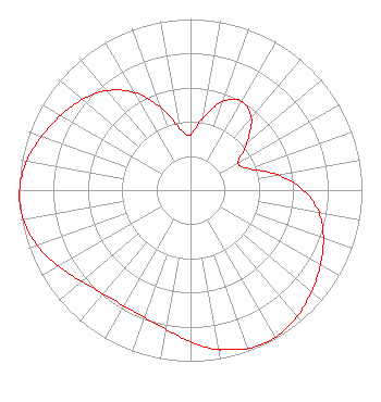 | |||||||||||||||||||||
| Azimuth | Ratio | Azimuth | Ratio | Azimuth | Ratio | Azimuth | Ratio | |||||||||||||||
| 0 | 0.322 | 10 | 0.429 | 20 | 0.551 | 30 | 0.599 | |||||||||||||||
| 40 | 0.551 | 50 | 0.429 | 60 | 0.320 | 70 | 0.364 | |||||||||||||||
| 80 | 0.515 | 90 | 0.660 | 100 | 0.761 | 110 | 0.825 | |||||||||||||||
| 120 | 0.874 | 130 | 0.922 | 140 | 0.966 | 150 | 0.992 | |||||||||||||||
| 160 | 0.986 | 169 | 0.950 | 170 | 0.945 | 180 | 0.884 | |||||||||||||||
| 190 | 0.826 | 200 | 0.790 | 210 | 0.779 | 220 | 0.791 | |||||||||||||||
| 230 | 0.829 | 240 | 0.888 | 250 | 0.950 | 260 | 0.991 | |||||||||||||||
| 267 | 1.000 | 270 | 0.998 | 280 | 0.971 | 290 | 0.924 | |||||||||||||||
| 300 | 0.874 | 310 | 0.824 | 320 | 0.759 | 330 | 0.659 | |||||||||||||||
| 340 | 0.517 | 350 | 0.367 | |||||||||||||||||||
Structure Registration Number 1022899 Structure Type: GTOWER Registered To: Fox Television Stations, LLC Structure Address: 550 Gramsie Rd Shoreview, MN County Name: Ramsey County ASR Issued: 09/07/2023 Date Built: 09/15/2023 Site Elevation: 277 m (909 ft.) Structure Height: 425 m (1394 ft.) Height Overall: 446.8 m (1466 ft.) Overall Height AMSL: 723.8 m (2375 ft.) FAA Determination: 06/29/2023 FAA Study #: 2023-AGL-11497-OE FAA Circular #: 70/7460-1M Paint & Light FAA Chapters: 4, 9, 15 PRIOR STUDIES 1991-AGL-1745-OE / 2023-AGL-10731-OE 45-03-30.0 N 93-07-28.0 W (NAD 83) 45-03-30.1 N 93-07-27.2 W (Converted to NAD 27) |
172 East 4th Street Saint Paul, MN 55101 Phone: 651-229-1112 Not-for-Profit | Title: Manager, Broadcast Engineering Date: 10/10/2023 Application Certifier Twin Cities PBS Twin Cities Public Television Inc. 172 East 4th Street Saint Paul, MN 55101 Applicant Ricky Weston Twin Cities Pbs 172 East 4th Street Saint Paul, MN 55101 Manager of Broadcast Engineering David Sanderford Intelligent Design Services, Inc. 1957 Reynolds Dr. Azle, TX 76020 Brad Deutsch Foster Garvey P.c. 1000 Potomac St., Nw Suite 200 Washington, DC 20007 Counsel | ||||||||||||||||||||
|
| |||||||||||||||||||||
