
FCCInfo.com
A Service of Cavell, Mertz & Associates, Inc.
(855) FCC-INFO
|
|
|
|
|
||||||||||||||||
|
|
Status: STA – Special Temporary Authority (Licensed And Silent) Application Accepted: 10/12/2023 STA Expires: 03/25/2024 File Number: -0000222753 FCC Website Links: LMS Facility Details This Application Other K06PT-D Applications Including Superseded Applications Mailing Address Correspondence for K06PT-D Correspondence related to application -0000222753 Service Contour - Open Street Map or USGS Map (43 dBu) Service Contour - KML / Google Earth (43 dBu) Rabbit Ears Info Search for K06PT-D Site Location: 39-00-52.1 N 92-16-32.7 W (NAD 83) Site Location: 39-00-52.0 N 92-16-32.0 W (Converted to NAD 27) ERP: 0.1 kW Polarization: Horizontally polarized R/C AGL: 10 m (33 ft.) R/C AMSL: 264.5 m (868 ft.) Emission Mask: Simple Site Elevation: 254.5 m. (835 ft.) Height Overall*: 319.7 m (1049 ft.) (* As Filed In This Application, may differ from ASR Data, Below.) Directional Antenna - Antenna Make/Model: Scala TVO-4 Antenna ID: 41530 Polarization: Horizontally polarized | ||||||||||||||||||
| Antenna Data for Antenna Id: 41530 K06PT-D LD File: -0000222753 Scala - TVO-4 Service: LD Standard Pattern: Y Pattern and Field Values Include a 70° Clockwise Rotation | 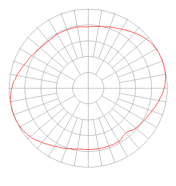 | ||||||||||||||||||
| Azimuth | Ratio | Azimuth | Ratio | Azimuth | Ratio | Azimuth | Ratio | ||||||||||||
| 0 | 0.774 | 10 | 0.788 | 20 | 0.818 | 30 | 0.857 | ||||||||||||
| 40 | 0.911 | 50 | 0.962 | 60 | 0.992 | 70 | 1.000 | ||||||||||||
| 80 | 0.992 | 90 | 0.962 | 100 | 0.911 | 110 | 0.857 | ||||||||||||
| 120 | 0.818 | 130 | 0.788 | 140 | 0.744 | 150 | 0.780 | ||||||||||||
| 160 | 0.780 | 170 | 0.780 | 180 | 0.776 | 190 | 0.782 | ||||||||||||
| 200 | 0.812 | 210 | 0.848 | 220 | 0.899 | 230 | 0.953 | ||||||||||||
| 240 | 0.988 | 250 | 1.000 | 260 | 0.992 | 270 | 0.962 | ||||||||||||
| 280 | 0.911 | 290 | 0.857 | 300 | 0.818 | 310 | 0.788 | ||||||||||||
| 320 | 0.774 | 330 | 0.780 | 340 | 0.780 | 350 | 0.780 | ||||||||||||
Structure Registration Number 1027181 Structure Type: GTOWER Registered To: VB Nimbus, LLC Structure Address: 6000 Brown Station Rd Columbia, MO County Name: Boone County ASR Issued: 10/13/2020 Date Built: 02/18/1998 Site Elevation: 254.5 m (835 ft.) Structure Height: 318.8 m (1046 ft.) Height Overall: 319.7 m (1049 ft.) Overall Height AMSL: 574.2 m (1884 ft.) FAA Determination: 07/19/2016 FAA Study #: 2015-ACE-3518-OE FAA Circular #: 70/7460-1L Paint & Light FAA Chapters: 3, 4, 5, 12 PRIOR STUDY 2009-ACE-2145-OE 39-00-52.1 N 92-16-32.7 W (NAD 83) 39-00-52.0 N 92-16-32.0 W (Converted to NAD 27) |
Limited Liability Company | Title: Ceo Date: 10/12/2023 Application Certifier Bridge News Llc 38955 Hills Tech Dr. Farmington Hills, MI 48331 Applicant Dan J Alpert The Law Office Of Dan J. Alpert 2120 21st Rd. N Arlington, VA 22201 Legal Counsel | |||||||||||||||||