
FCCInfo.com
A Service of Cavell, Mertz & Associates, Inc.
(855) FCC-INFO
|
|
|
Virtual Channel 51 |
|
||||||||||||||||
|
|
Repacking Information: No changes Status: Construction Permit Application Accepted: 10/18/2023 WWJX CP Expires: 10/23/2026 File Number: -0000223330 FCC Website Links: LMS Facility Details This Application Other WWJX Applications Including Superseded Applications Mailing Address Correspondence for WWJX Correspondence related to application -0000223330 Service Contour - Open Street Map or USGS Map (41 dBu) Service Contour - KML / Google Earth (41 dBu) Public Inspection Files Rabbit Ears Info Search for WWJX Site Location: 32-12-29.0 N 90-24-50.0 W (NAD 83) Site Location: 32-12-28.5 N 90-24-49.7 W (Converted to NAD 27) ERP: 50 kW Polarization: Elliptically polarized HAAT: 256 m (840 ft.) Electrical Beam Tilt: 1.0 degree R/C AGL: 225.6 m (740 ft.) R/C AMSL: 344.4 m (1130 ft.) Site Elevation: 118.8 m. (390 ft.) Height Overall*: 306 m (1004 ft.) (* As Filed In This Application, may differ from ASR Data, Below.) Directional Antenna - Antenna Make/Model: Alive ATC-BCE416M-V3-23 Antenna ID: 1011191 Polarization: Elliptically polarized | ||||||||||||||||||
| Antenna Data for Antenna Id: 1011191 WWJX DT File: -0000223330 Alive - ATC-BCE416M-V3-23 Service: DT Standard Pattern: N Pattern and Field Values Include a 45° Clockwise Rotation | 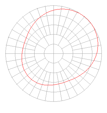 | ||||||||||||||||||
| Azimuth | Ratio | Azimuth | Ratio | Azimuth | Ratio | Azimuth | Ratio | ||||||||||||
| 5 | 0.918 | 15 | 0.953 | 25 | 0.979 | 35 | 0.995 | ||||||||||||
| 45 | 1.000 | 55 | 0.995 | 65 | 0.979 | 75 | 0.953 | ||||||||||||
| 85 | 0.918 | 95 | 0.876 | 105 | 0.829 | 115 | 0.781 | ||||||||||||
| 125 | 0.734 | 135 | 0.694 | 145 | 0.663 | 155 | 0.645 | ||||||||||||
| 165 | 0.641 | 175 | 0.647 | 185 | 0.661 | 195 | 0.679 | ||||||||||||
| 205 | 0.694 | 215 | 0.705 | 225 | 0.709 | 235 | 0.705 | ||||||||||||
| 245 | 0.694 | 255 | 0.678 | 265 | 0.661 | 275 | 0.647 | ||||||||||||
| 285 | 0.641 | 295 | 0.645 | 305 | 0.663 | 315 | 0.694 | ||||||||||||
| 325 | 0.734 | 335 | 0.781 | 345 | 0.829 | 355 | 0.876 | ||||||||||||
Structure Registration Number 1041785 Structure Type: TOWER Registered To: Vertical Bridge CC FM, LLC Structure Address: 1330 Moses Rd Raymond, MS County Name: Hinds County ASR Issued: 11/08/2018 Date Built: 02/01/1989 Site Elevation: 118.8 m (390 ft.) Structure Height: 274.3 m (900 ft.) Height Overall: 306 m (1004 ft.) Overall Height AMSL: 424.8 m (1394 ft.) FAA Determination: 05/21/1991 FAA Study #: 89-ASO-356-OE FAA Circular #: 70/7460-1G Paint & Light FAA Chapters: 3, 4, 5, 9 RED LIGHTS/PAINT 32-12-29.0 N 90-24-50.0 W (NAD 83) 32-12-28.5 N 90-24-49.7 W (Converted to NAD 27) |
Marion, IL 62959 Phone: 618-997-4700 Not-for-Profit | Title: Vice-president, Legal Date: 10/18/2023 Application Certifier Radiant Life Ministries, Inc. Marion, IL 62959 Applicant Kevin T Fisher Smith And Fisher, Llc 4791 Wintergreen Court Woodbridge, VA 22192 Engineering Consultant Joseph C Chautin, III Hardy, Carey, Chautin & Balkin, Llp 1080 W. Causeway Approach Mandeville, LA 70471 Attorney at Law | |||||||||||||||||