
FCCInfo.com
A Service of Cavell, Mertz & Associates, Inc.
(855) FCC-INFO
|
|
|
Virtual Channel 21 |  |
|
||||||||||||||||||||||
|
|
Repacking Information: No changes Status: License Application Accepted: 11/13/2023 License Expires: 08/01/2029 File Number: -0000225738 FCC Website Links: LMS Facility Details This Application Other WBNA Applications Including Superseded Applications Mailing Address Correspondence for WBNA Correspondence related to application -0000225738 Service Contour - Open Street Map or USGS Map (36 dBu) Service Contour - KML / Google Earth (36 dBu) Public Inspection Files Rabbit Ears Info Search for WBNA Site Location: 38-01-59.0 N 85-45-17.0 W (NAD 83) Site Location: 38-01-58.8 N 85-45-17.1 W (Converted to NAD 27) ERP: 95 kW Polarization: Elliptically polarized HAAT: 200 m (656 ft.) R/C AGL: 117 m (384 ft.) R/C AMSL: 368.5 m (1209 ft.) Site Elevation: 251.5 m. (825 ft.) Height Overall*: 142.1 m (466 ft.) (* As Filed In This Application, may differ from ASR Data, Below.) Directional Antenna - Antenna Make/Model: DIELECTRIC TLS-V12B/VP-R Antenna ID: 1011249 Polarization: Elliptically polarized
| |||||||||||||||||||||||||
| Antenna Data for Antenna Id: 1011249 WBNA DT File: -0000225738 DIELECTRIC - TLS-V12B/VP-R Service: DT Standard Pattern: N | 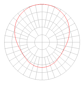 | |||||||||||||||||||||||||
| Azimuth | Ratio | Azimuth | Ratio | Azimuth | Ratio | Azimuth | Ratio | |||||||||||||||||||
| 0 | 1.000 | 10 | 0.995 | 20 | 0.979 | 30 | 0.952 | |||||||||||||||||||
| 40 | 0.916 | 50 | 0.873 | 60 | 0.823 | 70 | 0.770 | |||||||||||||||||||
| 80 | 0.717 | 90 | 0.670 | 100 | 0.633 | 110 | 0.609 | |||||||||||||||||||
| 120 | 0.600 | 130 | 0.604 | 140 | 0.618 | 150 | 0.636 | |||||||||||||||||||
| 160 | 0.652 | 170 | 0.664 | 180 | 0.668 | 190 | 0.664 | |||||||||||||||||||
| 200 | 0.652 | 210 | 0.636 | 220 | 0.618 | 230 | 0.604 | |||||||||||||||||||
| 240 | 0.600 | 250 | 0.609 | 260 | 0.633 | 270 | 0.670 | |||||||||||||||||||
| 280 | 0.717 | 290 | 0.770 | 300 | 0.823 | 310 | 0.873 | |||||||||||||||||||
| 320 | 0.916 | 330 | 0.952 | 340 | 0.979 | 350 | 0.995 | |||||||||||||||||||
Structure Registration Number 1044969 Structure Type: TOWER Registered To: WORD BROADCASTING NETWORK INC DBA = WBNA TV Structure Address: Bullit County Prayer Mountain Shepherdville, KY County Name: Bullitt County ASR Issued: 04/24/1998 Date Built: 01/01/1985 Site Elevation: 251.5 m (825 ft.) Structure Height: 141.2 m (463 ft.) Height Overall: 142.1 m (466 ft.) Overall Height AMSL: 393.6 m (1291 ft.) FAA Determination: 01/10/1985 FAA Study #: 84-ASO-1418-OE Paint & Light FAA Chapters: 1, 3, 4, 13, 21 RED LIGHTS/PAINT 38-01-59.0 N 85-45-17.0 W (NAD 83) 38-01-58.8 N 85-45-17.1 W (Converted to NAD 27) |
3701 Fern Valley Road Louisville, KY 40219 Phone: 502-964-2121 Not-for-Profit | Title: President Date: 11/13/2023 Application Certifier WBNA Word Broadcasting Network, Inc. 3701 Fern Valley Road Louisville, KY 40219 Applicant CALVIN BADER Word Broadcasting Network, Inc. 3701 Fern Valley Road Louisville, KY 40219 CHIEF ENGINEER CLARENCE M. BEVERAGE Communications Technologies 23 Binsted Drive Medford, NJ 08055 BROADCAST ENGINEERING CONSULTANT Tom Fawbush, jr Wbna 3701 Fern Valley Road Louisville, KY 40219 GM ANTHONY T LEPORE, ESQ Radiotvlaw Associates, Llc 4101 Albemarle St Nw #324 Washington, DC 20016 | ||||||||||||||||||||||||
| ||||||||||||||||||||||||||
