
FCCInfo.com
A Service of Cavell, Mertz & Associates, Inc.
(855) FCC-INFO
|
|
WDCN-LD from 07/02/2008 WDCN-LD from 04/27/2007 WDCN-LD from 05/28/1992 WDCN-LD from 03/19/1992 WDCN-LD from 05/31/1989 |
|
|
|||||||||||||||||||
|
|
Status: STA – Special Temporary Authority Application Accepted: 10/31/2023 STA Expires: 05/03/2024 File Number: -0000224397 FCC Website Links: LMS Facility Details This Application Other WDCN-LD Applications Including Superseded Applications Mailing Address Correspondence for WDCN-LD Correspondence related to application -0000224397 Service Contour - Open Street Map or USGS Map (43 dBu) Service Contour - KML / Google Earth (43 dBu) Rabbit Ears Info Search for WDCN-LD Site Location: 38-52-28.2 N 77-13-23.6 W (NAD 83) Site Location: 38-52-27.8 N 77-13-24.7 W (Converted to NAD 27) ERP: 3 kW Polarization: Circularly polarized Electrical Beam Tilt: .5 degrees R/C AGL: 169.7 m (557 ft.) R/C AMSL: 279.7 m (918 ft.) Emission Mask: Full Service Site Elevation: 110 m. (361 ft.) Height Overall*: 210 m (689 ft.) (* As Filed In This Application, may differ from ASR Data, Below.) Directional Antenna - Antenna Make/Model: Propagation System Inc PSILV5CLOG-6 CUSTOM Antenna ID: 1011219 Polarization: Circularly polarized | |||||||||||||||||||||
| Antenna Data for Antenna Id: 1011219 WDCN-LD LD File: -0000224397 Propagation System Inc - PSILV5CLOG-6 CUSTOM Service: LD Standard Pattern: N Pattern and Field Values Include a 210° Clockwise Rotation | 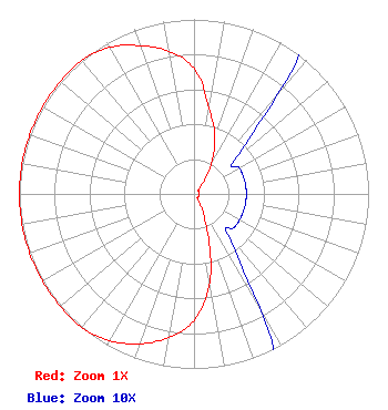 | |||||||||||||||||||||
| Azimuth | Ratio | Azimuth | Ratio | Azimuth | Ratio | Azimuth | Ratio | |||||||||||||||
| 0 | 0.720 | 10 | 0.500 | 20 | 0.350 | 30 | 0.200 | |||||||||||||||
| 40 | 0.075 | 50 | 0.030 | 60 | 0.030 | 70 | 0.030 | |||||||||||||||
| 80 | 0.030 | 90 | 0.030 | 100 | 0.030 | 110 | 0.030 | |||||||||||||||
| 120 | 0.030 | 130 | 0.030 | 140 | 0.030 | 150 | 0.075 | |||||||||||||||
| 160 | 0.219 | 170 | 0.514 | 180 | 0.727 | 190 | 0.835 | |||||||||||||||
| 200 | 0.914 | 210 | 0.970 | 220 | 1.000 | 230 | 1.000 | |||||||||||||||
| 240 | 1.000 | 250 | 1.000 | 260 | 1.000 | 270 | 1.000 | |||||||||||||||
| 280 | 1.000 | 290 | 1.000 | 300 | 1.000 | 310 | 1.000 | |||||||||||||||
| 320 | 1.000 | 330 | 0.970 | 340 | 0.904 | 350 | 0.830 | |||||||||||||||
Structure Registration Number 1017638 Structure Type: GTOWER Registered To: SBA Towers VIII, LLC Structure Address: 8101 A Lee Highway (va15666-a) Falls Church, VA County Name: Fairfax County ASR Issued: 06/29/2023 Date Built: 04/01/1983 Site Elevation: 110 m (361 ft.) Structure Height: 188.4 m (618 ft.) Height Overall: 210 m (689 ft.) Overall Height AMSL: 320 m (1050 ft.) FAA Determination: 01/12/2023 FAA Study #: 2022-AEA-1729-OE FAA Circular #: 70/7460-1L Paint & Light FAA Chapters: 4, 8, 12 OM&L to remain the same as prior studies = A MED-DUAL SYSTEM 38-52-28.2 N 77-13-23.6 W (NAD 83) 38-52-27.8 N 77-13-24.7 W (Converted to NAD 27) |
1945 Old Gallows Road Suite 650 Tysons, VA 22182 Phone: 703-761-5013 Limited Liability Company | Title: Member Date: 10/31/2023 Application Certifier Signal Above Llc 1945 Old Gallows Road Suite 650 Tysons, VA 22182 Applicant Ari Meltzer, Esq Wiley Rein Llp 2050 M Street, N.w. Washington, DC 20036 | ||||||||||||||||||||
| ||||||||||||||||||||||
