
FCCInfo.com
A Service of Cavell, Mertz & Associates, Inc.
(855) FCC-INFO
|
|
WCRN-LD from 05/18/2000 WCRN-LD from 05/08/1992 |
Virtual Channel 31 |
|
||||||||||||||||
|
|
Status: License Application Accepted: 11/13/2023 License Expires: 04/01/2031 File Number: -0000225987 FCC Website Links: LMS Facility Details This Application Other WCRN-LD Applications Including Superseded Applications Mailing Address Correspondence for WCRN-LD Correspondence related to application -0000225987 Service Contour - Open Street Map or USGS Map (51 dBu) Service Contour - KML / Google Earth (51 dBu) Rabbit Ears Info Search for WCRN-LD Site Location: 42-14-49.1 N 71-02-53.5 W (NAD 83) Site Location: 42-14-48.7 N 71-02-55.3 W (Converted to NAD 27) ERP: 15 kW Polarization: Elliptically polarized Electrical Beam Tilt: 1.0 degree R/C AGL: 198 m (650 ft.) R/C AMSL: 256 m (840 ft.) Emission Mask: Full Service Site Elevation: 58 m. (190 ft.) Height Overall*: 243.8 m (800 ft.) (* As Filed In This Application, may differ from ASR Data, Below.) Directional Antenna - Antenna Make/Model: ATC ATC-BCE410P3R-V1-30 SPECIAL Antenna ID: 1011251 Polarization: Elliptically polarized | ||||||||||||||||||
| Antenna Data for Antenna Id: 1011251 WCRN-LD LD File: -0000225987 ATC - ATC-BCE410P3R-V1-30 SPECIAL Service: LD Standard Pattern: N | 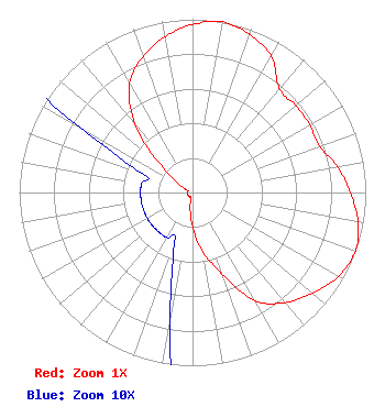 | ||||||||||||||||||
| Azimuth | Ratio | Azimuth | Ratio | Azimuth | Ratio | Azimuth | Ratio | ||||||||||||
| 0 | 0.970 | 10 | 1.000 | 20 | 0.970 | 30 | 0.910 | ||||||||||||
| 40 | 0.780 | 50 | 0.780 | 60 | 0.780 | 70 | 0.780 | ||||||||||||
| 80 | 0.850 | 90 | 0.910 | 100 | 0.970 | 110 | 1.000 | ||||||||||||
| 120 | 0.970 | 130 | 0.904 | 140 | 0.830 | 150 | 0.720 | ||||||||||||
| 160 | 0.500 | 170 | 0.350 | 180 | 0.200 | 190 | 0.075 | ||||||||||||
| 200 | 0.030 | 210 | 0.030 | 220 | 0.030 | 230 | 0.030 | ||||||||||||
| 240 | 0.030 | 250 | 0.030 | 260 | 0.030 | 270 | 0.030 | ||||||||||||
| 280 | 0.030 | 290 | 0.030 | 300 | 0.075 | 310 | 0.219 | ||||||||||||
| 320 | 0.514 | 330 | 0.727 | 340 | 0.835 | 350 | 0.914 | ||||||||||||
Structure Registration Number 1002115 Structure Type: GTOWER Registered To: Industrial Tower and Wireless, LLC Structure Address: 137 Bay View Corporate Drive Quincy, MA County Name: Norfolk County ASR Issued: 03/02/2023 Date Built: 02/01/1993 Site Elevation: 58 m (190 ft.) Structure Height: 239 m (784 ft.) Height Overall: 243.8 m (800 ft.) Overall Height AMSL: 301.8 m (990 ft.) FAA Determination: 02/24/2023 FAA Study #: 2022-ANE-2817-OE FAA Circular #: 70/7460-1L Paint & Light FAA Chapters: 3, 4, 5, 12 OM&L to remain the same as prior study = PAINT/RED LIGHTS 42-14-49.1 N 71-02-53.5 W (NAD 83) 42-14-48.7 N 71-02-55.3 W (Converted to NAD 27) |
500 Summer Street #502 Stamford, CT 06901 Phone: 203-349-9000 Limited Liability Company | Title: Managing Member Date: 11/13/2023 Application Certifier TYCHE MEDIA LLC Tyche Media Llc 500 Summer Street #502 Stamford, CT 06901 Applicant Davina S. Sashkin, Esq. Wilkinson Barker Knauer, Llp 1800 M Street Nw Suite 800n Washington, DC 20036 | |||||||||||||||||