
FCCInfo.com
A Service of Cavell, Mertz & Associates, Inc.
(855) FCC-INFO
|
|
|
|
|
||||||||||||||||
|
|
Status: Construction Permit Application Accepted: 11/30/2023 W11DH-D CP Expires: 10/13/2026 File Number: -0000229479 FCC Website Links: LMS Facility Details This Application Other W11DH-D Applications Including Superseded Applications Mailing Address Correspondence for W11DH-D Correspondence related to application -0000229479 Service Contour - Open Street Map or USGS Map (48 dBu) Service Contour - KML / Google Earth (48 dBu) Rabbit Ears Info Search for W11DH-D Site Location: 27-01-32.0 N 80-10-41.9 W (NAD 83) Site Location: 27-01-30.8 N 80-10-42.7 W (Converted to NAD 27) ERP: 1.8 kW Polarization: Horizontally polarized Electrical Beam Tilt: 2.5 degrees R/C AGL: 200 m (656 ft.) R/C AMSL: 204.9 m (672 ft.) Emission Mask: Full Service Site Elevation: 4.9 m. (16 ft.) Height Overall*: 311.5 m (1022 ft.) (* As Filed In This Application, may differ from ASR Data, Below.) Directional Antenna - Antenna Make/Model: Scala CL-713 ARRAY Antenna ID: 1011289 Polarization: Horizontally polarized | ||||||||||||||||||
| Antenna Data for Antenna Id: 1011289 W11DH-D LD File: -0000229479 Scala - CL-713 ARRAY Service: LD Standard Pattern: N | 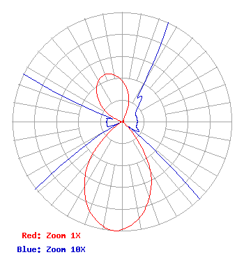 | ||||||||||||||||||
| Azimuth | Ratio | Azimuth | Ratio | Azimuth | Ratio | Azimuth | Ratio | ||||||||||||
| 0 | 0.374 | 10 | 0.285 | 20 | 0.180 | 30 | 0.041 | ||||||||||||
| 40 | 0.028 | 50 | 0.018 | 60 | 0.014 | 70 | 0.014 | ||||||||||||
| 80 | 0.014 | 90 | 0.014 | 100 | 0.014 | 110 | 0.014 | ||||||||||||
| 120 | 0.018 | 130 | 0.025 | 140 | 0.213 | 150 | 0.514 | ||||||||||||
| 160 | 0.732 | 170 | 0.898 | 180 | 0.985 | 184 | 1.000 | ||||||||||||
| 190 | 0.972 | 200 | 0.866 | 210 | 0.683 | 220 | 0.457 | ||||||||||||
| 230 | 0.141 | 240 | 0.014 | 250 | 0.014 | 260 | 0.014 | ||||||||||||
| 270 | 0.014 | 280 | 0.014 | 290 | 0.023 | 300 | 0.161 | ||||||||||||
| 310 | 0.265 | 320 | 0.360 | 330 | 0.429 | 340 | 0.457 | ||||||||||||
| 350 | 0.434 | ||||||||||||||||||
Structure Registration Number 1018573 Structure Type: GTOWER Registered To: American Towers LLC Structure Address: 3350 Se Bridge Rd (005020) Hobe Sound, FL County Name: Martin County ASR Issued: 05/16/2017 Date Built: 12/01/1996 Site Elevation: 4.9 m (16 ft.) Structure Height: 286.8 m (941 ft.) Height Overall: 311.5 m (1022 ft.) Overall Height AMSL: 316.4 m (1038 ft.) FAA Determination: 12/29/2010 FAA Study #: 2010-ASO-5657-OE FAA Circular #: 70/7460-1K Paint & Light FAA Chapters: 4, 7, 12 PRIOR STUDY 2007-ASO-382-OE 27-01-32.0 N 80-10-41.9 W (NAD 83) 27-01-30.8 N 80-10-42.7 W (Converted to NAD 27) |
16280 Nw 17th Street Pembroke Pines, FL 33028 Phone: 954-812-7381 Applicant | Title: Chief Executive Officer Date: 11/30/2023 Application Certifier FRANCOIS LECONTE Francois Leconte 16280 Nw 17th Street Pembroke Pines, FL 33028 Applicant James Stenberg Over The Air Rf Consulting Llc 25 Stroudwater Rd Portland, ME 04102 | |||||||||||||||||