
FCCInfo.com
A Service of Cavell, Mertz & Associates, Inc.
(855) FCC-INFO
|
|
WUPV from 09/15/1994 WUPV from 04/28/1986 |
Post-repack Channel 8 Virtual Channel 65 |  |
|
||||||||||||||||||
|
|
Repacking Information: Pre-Repack Channel: 47 Post-Repack Channel: 8 Post-Repack ERP: 7.98 kW Phase: 3 Completion Deadline: 6/21/2019 Find nearby TV Facilities Status: License Application Accepted: 12/07/2023 License Expires: 10/01/2028 File Number: -0000231993 FCC Website Links: LMS Facility Details This Application Other WUPV Applications Including Superseded Applications Mailing Address Correspondence for WUPV Correspondence related to application -0000231993 Service Contour - Open Street Map or USGS Map (36 dBu) Service Contour - KML / Google Earth (36 dBu) Public Inspection Files Rabbit Ears Info Search for WUPV Site Location: 37-44-32.0 N 77-15-14.0 W (NAD 83) Site Location: 37-44-31.5 N 77-15-15.1 W (Converted to NAD 27) ERP: 30 kW Polarization: Elliptically polarized HAAT: 257 m (843 ft.) Electrical Beam Tilt: 1.5 degrees R/C AGL: 265.5 m (871 ft.) R/C AMSL: 294.5 m (966 ft.) Site Elevation: 29 m. (95 ft.) Height Overall*: 273.1 m (896 ft.) (* As Filed In This Application, may differ from ASR Data, Below.) Directional Antenna - Antenna Make/Model: DIELECTRIC THV-6A8/VP-R C200 Antenna ID: 1011302 Polarization: Elliptically polarized | |||||||||||||||||||||
| Antenna Data for Antenna Id: 1011302 WUPV DT File: -0000231993 DIELECTRIC - THV-6A8/VP-R C200 Service: DT Standard Pattern: N | 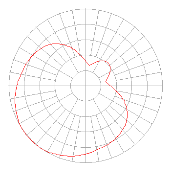 | |||||||||||||||||||||
| Azimuth | Ratio | Azimuth | Ratio | Azimuth | Ratio | Azimuth | Ratio | |||||||||||||||
| 0 | 0.320 | 10 | 0.270 | 20 | 0.310 | 30 | 0.370 | |||||||||||||||
| 40 | 0.410 | 50 | 0.410 | 60 | 0.370 | 70 | 0.310 | |||||||||||||||
| 80 | 0.270 | 90 | 0.320 | 100 | 0.400 | 110 | 0.520 | |||||||||||||||
| 120 | 0.620 | 130 | 0.700 | 140 | 0.750 | 150 | 0.790 | |||||||||||||||
| 160 | 0.820 | 170 | 0.850 | 180 | 0.890 | 190 | 0.930 | |||||||||||||||
| 200 | 0.960 | 210 | 0.990 | 220 | 1.000 | 230 | 1.000 | |||||||||||||||
| 240 | 0.990 | 250 | 0.960 | 260 | 0.930 | 270 | 0.890 | |||||||||||||||
| 280 | 0.850 | 290 | 0.820 | 300 | 0.790 | 310 | 0.750 | |||||||||||||||
| 320 | 0.700 | 330 | 0.620 | 340 | 0.520 | 350 | 0.400 | |||||||||||||||
Structure Registration Number 1035293 Structure Type: GTOWER Registered To: Gray Media Group, Inc. Structure Address: 1148 Mahixon Road Manquin, VA County Name: King William County ASR Issued: 02/11/2019 Date Built: 03/14/2017 Site Elevation: 29 m (95 ft.) Structure Height: 259.5 m (851 ft.) Height Overall: 273.1 m (896 ft.) Overall Height AMSL: 302.1 m (991 ft.) FAA Determination: 06/16/1997 FAA Study #: 97-AEA-1301-OE FAA Circular #: 70/7460-1J Paint & Light FAA Chapters: 4, 9, 13 37-44-32.0 N 77-15-14.0 W (NAD 83) 37-44-31.5 N 77-15-15.1 W (Converted to NAD 27) |
4370 Peachtree Road, Ne Atlanta, GA 30319 Phone: 404-504-9828 Limited Liability Company | Title: Assistant Secretary Date: 12/07/2023 Application Certifier WUPV Gray Television Licensee, Llc 4370 Peachtree Road, Ne Atlanta, GA 30319 Applicant David Burke Gray Television Licensee, Llc 201 Monroe Street Montgomery, AL 36104 Senior Vice President and CTO Joan Stewart Wiley Rein Llp 2050 M Street Nw Washington, DC 20036 | ||||||||||||||||||||
| ||||||||||||||||||||||
