
FCCInfo.com
A Service of Cavell, Mertz & Associates, Inc.
(855) FCC-INFO
|
|
KCPO-LP from 04/20/2020 KCPO-LP from 08/15/2014 KCPO-LP from 03/12/2014 KCPO-LP from 10/23/1998 KCPO-LP from 03/25/1992 KCPO-LP from 04/20/1989 KCPO-LP from 04/13/1989 |
|
|
||||||||||||||||||||
|
|
Status: License Application Accepted: 12/06/2023 License Expires: 07/26/2025 File Number: -0000231702 FCC Website Links: LMS Facility Details This Application Other KCPO-LD Applications Including Superseded Applications Mailing Address Correspondence for KCPO-LD Correspondence related to application -0000231702 Service Contour - Open Street Map or USGS Map (51 dBu) Service Contour - KML / Google Earth (51 dBu) Rabbit Ears Info Search for KCPO-LD Site Location: 43-33-14.0 N 96-41-06.0 W (NAD 83) Site Location: 43-33-14.1 N 96-41-04.8 W (Converted to NAD 27) ERP: 5 kW Polarization: Horizontally polarized Electrical Beam Tilt: 0.25 degrees R/C AGL: 51 m (167 ft.) R/C AMSL: 492.9 m (1617 ft.) Emission Mask: Full Service Site Elevation: 441.9 m. (1450 ft.) Height Overall*: 60.4 m (198 ft.) (* As Filed In This Application, may differ from ASR Data, Below.) Directional Antenna - Antenna Make/Model: Andrew ALP8L7-HSOC Antenna ID: 17072 Polarization: Horizontally polarized
| ||||||||||||||||||||||
| Antenna Data for Antenna Id: 17072 KCPO-LD LD File: -0000231702 Andrew - ALP8L7-HSOC Service: LD Standard Pattern: Y Pattern and Field Values Include a 230° Clockwise Rotation | 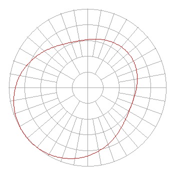 | ||||||||||||||||||||||
| Azimuth | Ratio | Azimuth | Ratio | Azimuth | Ratio | Azimuth | Ratio | ||||||||||||||||
| 0 | 0.608 | 10 | 0.623 | 20 | 0.642 | 30 | 0.659 | ||||||||||||||||
| 40 | 0.672 | 50 | 0.676 | 60 | 0.672 | 70 | 0.659 | ||||||||||||||||
| 80 | 0.642 | 90 | 0.623 | 100 | 0.608 | 110 | 0.602 | ||||||||||||||||
| 120 | 0.609 | 130 | 0.631 | 140 | 0.668 | 150 | 0.715 | ||||||||||||||||
| 160 | 0.767 | 170 | 0.820 | 180 | 0.871 | 190 | 0.915 | ||||||||||||||||
| 200 | 0.951 | 210 | 0.978 | 220 | 0.994 | 230 | 1.000 | ||||||||||||||||
| 240 | 0.994 | 250 | 0.978 | 260 | 0.951 | 270 | 0.915 | ||||||||||||||||
| 280 | 0.871 | 290 | 0.820 | 300 | 0.767 | 310 | 0.715 | ||||||||||||||||
| 320 | 0.668 | 330 | 0.631 | 340 | 0.609 | 350 | 0.602 | ||||||||||||||||
Structure Registration Number 1050703 Structure Type: TOWER Registered To: FRIESSEN, WARREN DBA = FRIESSEN CONSTRUCTION Structure Address: Jct Hwy 11 & E 6th St. Sioux Falls, SD County Name: Minnehaha County ASR Issued: 06/19/1998 Date Built: 02/13/1990 Site Elevation: 441.9 m (1450 ft.) Structure Height: 60.4 m (198 ft.) Height Overall: 60.4 m (198 ft.) Overall Height AMSL: 502.3 m (1648 ft.) FAA Determination: 02/26/1990 FAA Study #: 89-AGL-2023-OE FAA Circular #: Paint & Light FAA Chapters: NONE 43-33-14.0 N 96-41-06.0 W (NAD 83) 43-33-14.1 N 96-41-04.8 W (Converted to NAD 27) |
Sioux Falls, SD 57109 Phone: 605-254-7600 Corporation | Title: President Date: 12/06/2023 Application Certifier G.I.G., Inc. G.i.g., Inc. Sioux Falls, SD 57109 Applicant Richard C Goetz R & L Media Systems 135 N Country Club Dr Hendersonville, TN 37075 Broadcast Consultant Aaron P Shainis Shainis & Peltzman, Chartered 1850 M Street Nw Suite 240 Washington, DC 20036 FCC Legal Counsel | |||||||||||||||||||||
| |||||||||||||||||||||||