
FCCInfo.com
A Service of Cavell, Mertz & Associates, Inc.
(855) FCC-INFO
|
|
KHII-TV from 10/26/2009 KHII-TV from 06/01/1982 KHII-TV from 10/25/1980 |
Virtual Channel 9 |  |
|
|||||||||||||||||||||
|
|
Repacking Information: No changes Status: License Application Accepted: 12/11/2023 License Expires: 02/01/2023 File Number: -0000231709 FCC Website Links: LMS Facility Details This Application Other KHII-TV Applications Including Superseded Applications Mailing Address Correspondence for KHII-TV Correspondence related to application -0000231709 Service Contour - Open Street Map or USGS Map (41 dBu) Service Contour - KML / Google Earth (41 dBu) Public Inspection Files Rabbit Ears Info Search for KHII-TV Site Location: 21-23-52.0 N 158-06-00.0 W (NAD 83) Site Location: 21-24-03.4 N 158-06-09.9 W (Converted to NAD 27) ERP: 40 kW Polarization: Horizontally polarized HAAT: 629 m (2064 ft.) Electrical Beam Tilt: 0.7 degrees R/C AGL: 49 m (161 ft.) R/C AMSL: 804.9 m (2641 ft.) Site Elevation: 755.9 m. (2480 ft.) Height Overall*: 60.9 m (200 ft.) (* As Filed In This Application, may differ from ASR Data, Below.) Directional Antenna - Antenna Make/Model: DIELECTRIC TUA-BP3SP-6/18M-1-S Antenna ID: 91062 Polarization: Horizontally polarized | ||||||||||||||||||||||||
| Antenna Data for Antenna Id: 91062 KHII-TV DT File: -0000231709 DIELECTRIC - TUA-BP3SP-6/18M-1-S Service: DT Standard Pattern: Y | 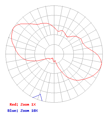 | ||||||||||||||||||||||||
| Azimuth | Ratio | Azimuth | Ratio | Azimuth | Ratio | Azimuth | Ratio | ||||||||||||||||||
| 0 | 0.549 | 10 | 0.477 | 20 | 0.510 | 30 | 0.468 | ||||||||||||||||||
| 36 | 0.448 | 40 | 0.461 | 50 | 0.564 | 60 | 0.631 | ||||||||||||||||||
| 70 | 0.634 | 80 | 0.704 | 90 | 0.875 | 100 | 0.990 | ||||||||||||||||||
| 103 | 1.000 | 110 | 0.982 | 120 | 0.911 | 130 | 0.810 | ||||||||||||||||||
| 140 | 0.705 | 150 | 0.552 | 160 | 0.337 | 170 | 0.151 | ||||||||||||||||||
| 172 | 0.142 | 180 | 0.167 | 190 | 0.119 | 198 | 0.090 | ||||||||||||||||||
| 200 | 0.091 | 210 | 0.110 | 220 | 0.140 | 230 | 0.142 | ||||||||||||||||||
| 240 | 0.211 | 250 | 0.427 | 260 | 0.623 | 270 | 0.739 | ||||||||||||||||||
| 280 | 0.830 | 290 | 0.929 | 300 | 0.979 | 303 | 0.989 | ||||||||||||||||||
| 310 | 0.942 | 320 | 0.810 | 330 | 0.703 | 340 | 0.671 | ||||||||||||||||||
| 350 | 0.631 | ||||||||||||||||||||||||
Structure Registration Number 1007114 Structure Type: Registered To: Gray Media Group, Inc. Structure Address: 4.8 Km Ne Of Nanakuli Palehua, HI County Name: Honolulu County ASR Issued: 02/11/2019 Date Built: 01/01/1989 Site Elevation: 755.9 m (2480 ft.) Structure Height: 60.9 m (200 ft.) Height Overall: 60.9 m (200 ft.) Overall Height AMSL: 816.8 m (2680 ft.) FAA Determination: 05/23/1989 FAA Study #: 88-AWP-938-OE Paint & Light FAA Chapters: NONE 21-23-52.0 N 158-06-00.0 W (NAD 83) 21-24-03.4 N 158-06-09.9 W (Converted to NAD 27) |
545 E. John Carpenter Freeway Suite 700 Irving, TX 75062 Phone: 972-373-8800 Corporation | Title: Associate General Counsel Date: 12/11/2023 Application Certifier Nexstar Media Inc. 545 E. John Carpenter Freeway Suite 700 Irving, TX 75062 Applicant Jason Roberts Nexstar Media Inc. 545 E. John Carpenter Freeway Suite 700 Irving, TX 75062 Associate General Counsel | |||||||||||||||||||||||
| |||||||||||||||||||||||||
