
FCCInfo.com
A Service of Cavell, Mertz & Associates, Inc.
(855) FCC-INFO
|
|
KJZZ-TV from 02/29/1988 KJZZ-TV from 11/06/1986 |
Post-repack Channel 19 Virtual Channel 14 |  |
|
||||||||||||||||||||||||||||||||||||||||||||||||||||||||||||||||||||||||||||||||||||||||||||||||||||||||||||||||||||||||||||||||||||||||||||||||||||||||||||||||||||||||||||||||||||||||||||||||||||||||||||||||||||||||||||||||||||||||||||||||||||||||||||||||||||||||||||
|
|
Repacking Information: Pre-Repack Channel: 46 Post-Repack Channel: 19 Post-Repack ERP: 114 kW Phase: 1 Completion Deadline: 11/30/2018 Find nearby TV Facilities Status: License Application Accepted: 12/14/2023 License Expires: 10/01/2022 File Number: -0000232994 FCC Website Links: LMS Facility Details This Application Other KJZZ-TV Applications Including Superseded Applications Mailing Address Correspondence for KJZZ-TV Correspondence related to application -0000232994 Service Contour - Open Street Map or USGS Map (41 dBu) Service Contour - KML / Google Earth (41 dBu) Public Inspection Files Rabbit Ears Info Search for KJZZ-TV Site Location: 40-39-33.0 N 112-12-10.0 W (NAD 83) Site Location: 40-39-33.2 N 112-12-07.2 W (Converted to NAD 27) ERP: 312 kW Polarization: Horizontally polarized HAAT: 1258.8 m (4130 ft.) Electrical Beam Tilt: 1.8 degrees R/C AGL: 79.8 m (262 ft.) R/C AMSL: 2833.8 m (9297 ft.) Site Elevation: 2754 m. (9035 ft.) Height Overall*: 94 m (308 ft.) (* As Filed In This Application, may differ from ASR Data, Below.) Directional Antenna - Antenna Make/Model: KATHREIN 759.25063 Antenna ID: 1011326 Polarization: Horizontally polarized
| |||||||||||||||||||||||||||||||||||||||||||||||||||||||||||||||||||||||||||||||||||||||||||||||||||||||||||||||||||||||||||||||||||||||||||||||||||||||||||||||||||||||||||||||||||||||||||||||||||||||||||||||||||||||||||||||||||||||||||||||||||||||||||||||||||||||||||||||
| Antenna Data for Antenna Id: 1011326 KJZZ-TV DT File: -0000232994 KATHREIN - 759.25063 Service: DT Standard Pattern: N | 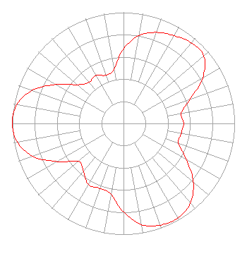 | |||||||||||||||||||||||||||||||||||||||||||||||||||||||||||||||||||||||||||||||||||||||||||||||||||||||||||||||||||||||||||||||||||||||||||||||||||||||||||||||||||||||||||||||||||||||||||||||||||||||||||||||||||||||||||||||||||||||||||||||||||||||||||||||||||||||||||||||
| Azimuth | Ratio | Azimuth | Ratio | Azimuth | Ratio | Azimuth | Ratio | |||||||||||||||||||||||||||||||||||||||||||||||||||||||||||||||||||||||||||||||||||||||||||||||||||||||||||||||||||||||||||||||||||||||||||||||||||||||||||||||||||||||||||||||||||||||||||||||||||||||||||||||||||||||||||||||||||||||||||||||||||||||||||||||||||||||||
| 0 | 0.671 | 10 | 0.804 | 20 | 0.872 | 30 | 0.913 | |||||||||||||||||||||||||||||||||||||||||||||||||||||||||||||||||||||||||||||||||||||||||||||||||||||||||||||||||||||||||||||||||||||||||||||||||||||||||||||||||||||||||||||||||||||||||||||||||||||||||||||||||||||||||||||||||||||||||||||||||||||||||||||||||||||||||
| 40 | 0.948 | 50 | 0.944 | 60 | 0.823 | 70 | 0.637 | |||||||||||||||||||||||||||||||||||||||||||||||||||||||||||||||||||||||||||||||||||||||||||||||||||||||||||||||||||||||||||||||||||||||||||||||||||||||||||||||||||||||||||||||||||||||||||||||||||||||||||||||||||||||||||||||||||||||||||||||||||||||||||||||||||||||||
| 80 | 0.528 | 90 | 0.541 | 100 | 0.527 | 110 | 0.526 | |||||||||||||||||||||||||||||||||||||||||||||||||||||||||||||||||||||||||||||||||||||||||||||||||||||||||||||||||||||||||||||||||||||||||||||||||||||||||||||||||||||||||||||||||||||||||||||||||||||||||||||||||||||||||||||||||||||||||||||||||||||||||||||||||||||||||
| 120 | 0.653 | 130 | 0.819 | 140 | 0.937 | 150 | 0.981 | |||||||||||||||||||||||||||||||||||||||||||||||||||||||||||||||||||||||||||||||||||||||||||||||||||||||||||||||||||||||||||||||||||||||||||||||||||||||||||||||||||||||||||||||||||||||||||||||||||||||||||||||||||||||||||||||||||||||||||||||||||||||||||||||||||||||||
| 160 | 0.973 | 170 | 0.923 | 180 | 0.796 | 190 | 0.646 | |||||||||||||||||||||||||||||||||||||||||||||||||||||||||||||||||||||||||||||||||||||||||||||||||||||||||||||||||||||||||||||||||||||||||||||||||||||||||||||||||||||||||||||||||||||||||||||||||||||||||||||||||||||||||||||||||||||||||||||||||||||||||||||||||||||||||
| 200 | 0.622 | 210 | 0.633 | 220 | 0.561 | 230 | 0.529 | |||||||||||||||||||||||||||||||||||||||||||||||||||||||||||||||||||||||||||||||||||||||||||||||||||||||||||||||||||||||||||||||||||||||||||||||||||||||||||||||||||||||||||||||||||||||||||||||||||||||||||||||||||||||||||||||||||||||||||||||||||||||||||||||||||||||||
| 240 | 0.687 | 250 | 0.867 | 260 | 0.970 | 270 | 1.000 | |||||||||||||||||||||||||||||||||||||||||||||||||||||||||||||||||||||||||||||||||||||||||||||||||||||||||||||||||||||||||||||||||||||||||||||||||||||||||||||||||||||||||||||||||||||||||||||||||||||||||||||||||||||||||||||||||||||||||||||||||||||||||||||||||||||||||
| 280 | 0.974 | 290 | 0.873 | 300 | 0.703 | 310 | 0.542 | |||||||||||||||||||||||||||||||||||||||||||||||||||||||||||||||||||||||||||||||||||||||||||||||||||||||||||||||||||||||||||||||||||||||||||||||||||||||||||||||||||||||||||||||||||||||||||||||||||||||||||||||||||||||||||||||||||||||||||||||||||||||||||||||||||||||||
| 320 | 0.484 | 330 | 0.498 | 340 | 0.462 | 350 | 0.493 | |||||||||||||||||||||||||||||||||||||||||||||||||||||||||||||||||||||||||||||||||||||||||||||||||||||||||||||||||||||||||||||||||||||||||||||||||||||||||||||||||||||||||||||||||||||||||||||||||||||||||||||||||||||||||||||||||||||||||||||||||||||||||||||||||||||||||
Structure Registration Number 1062408 Structure Type: TOWER Registered To: DTV Utah, LC Structure Address: Farnsworth Peak, 10 Kilometers Sw Of Magna Salt Lake City, UT County Name: Salt Lake County ASR Issued: 11/05/2020 Date Built: 10/28/1999 Site Elevation: 2754 m (9035 ft.) Structure Height: 94 m (308 ft.) Height Overall: 94 m (308 ft.) Overall Height AMSL: 2848 m (9344 ft.) FAA Determination: 03/11/1999 FAA Study #: 99-ANM-0178-OE FAA Circular #: 70/7460-1J Paint & Light FAA Chapters: 4, 8, 13 Removed expiration date from determination. Scenario 1./jjs/case#635066 40-39-33.0 N 112-12-10.0 W (NAD 83) 40-39-33.2 N 112-12-07.2 W (Converted to NAD 27) |
1200 Seventeenth Street, Nw Washington, DC 20036 Phone: 202-663-8195 Limited Liability Company | Title: Evp And Cfo, Sinclair, Inc Date: 12/14/2023 Application Certifier Kjzz Licensee, Llc 1200 Seventeenth Street, Nw Washington, DC 20036 Applicant Kevin Fisher Smith And Fisher, Llc 4791 Wintergreen Court Woodbridge, VA 22192 Miles S. Mason, Esq Pillsbury Winthrop Shaw Pittman Llp 1200 Seventeenth Street, Nw Washington, DC 20036 | ||||||||||||||||||||||||||||||||||||||||||||||||||||||||||||||||||||||||||||||||||||||||||||||||||||||||||||||||||||||||||||||||||||||||||||||||||||||||||||||||||||||||||||||||||||||||||||||||||||||||||||||||||||||||||||||||||||||||||||||||||||||||||||||||||||||||||||||
|
| |||||||||||||||||||||||||||||||||||||||||||||||||||||||||||||||||||||||||||||||||||||||||||||||||||||||||||||||||||||||||||||||||||||||||||||||||||||||||||||||||||||||||||||||||||||||||||||||||||||||||||||||||||||||||||||||||||||||||||||||||||||||||||||||||||||||||||||||
