
FCCInfo.com
A Service of Cavell, Mertz & Associates, Inc.
(855) FCC-INFO
|
|
from 08/01/2022 from 05/19/2021 from 07/11/2012 |
|
|
||||||||||||||||
|
|
Status: License Application Accepted: 01/05/2024 License Expires: 08/01/2029 File Number: -0000234885 FCC Website Links: LMS Facility Details This Application Other WTNX-LD Applications Including Superseded Applications Mailing Address Correspondence for WTNX-LD Correspondence related to application -0000234885 Service Contour - Open Street Map or USGS Map (51 dBu) Service Contour - KML / Google Earth (51 dBu) Rabbit Ears Info Search for WTNX-LD Site Location: 36-16-04.9 N 86-47-44.7 W (NAD 83) Site Location: 36-16-04.7 N 86-47-44.7 W (Converted to NAD 27) ERP: 15 kW Polarization: Elliptically polarized Electrical Beam Tilt: 1.0 degree R/C AGL: 285.3 m (936 ft.) R/C AMSL: 517 m (1696 ft.) Emission Mask: Full Service Site Elevation: 231.7 m. (760 ft.) Height Overall*: 392.9 m (1289 ft.) (* As Filed In This Application, may differ from ASR Data, Below.) Directional Antenna - Antenna Make/Model: Dielectric TLP-8M/VP Antenna ID: 1010173 Polarization: Elliptically polarized | ||||||||||||||||||
| Antenna Data for Antenna Id: 1010173 WTNX-LD LD File: -0000234885 Dielectric - TLP-8M/VP Service: LD Standard Pattern: Y Pattern and Field Values Include a 200° Clockwise Rotation | 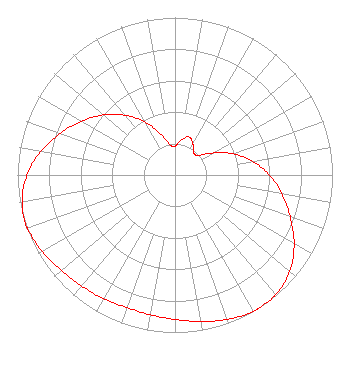 | ||||||||||||||||||
| Azimuth | Ratio | Azimuth | Ratio | Azimuth | Ratio | Azimuth | Ratio | ||||||||||||
| 0 | 0.184 | 10 | 0.226 | 20 | 0.257 | 30 | 0.227 | ||||||||||||
| 40 | 0.183 | 50 | 0.194 | 60 | 0.278 | 70 | 0.393 | ||||||||||||
| 80 | 0.502 | 90 | 0.599 | 100 | 0.688 | 110 | 0.778 | ||||||||||||
| 120 | 0.873 | 130 | 0.951 | 140 | 0.993 | 147 | 1.000 | ||||||||||||
| 150 | 0.998 | 160 | 0.976 | 170 | 0.944 | 180 | 0.918 | ||||||||||||
| 190 | 0.901 | 200 | 0.895 | 210 | 0.908 | 220 | 0.921 | ||||||||||||
| 230 | 0.942 | 240 | 0.974 | 250 | 0.995 | 252 | 1.000 | ||||||||||||
| 260 | 0.985 | 270 | 0.940 | 280 | 0.865 | 290 | 0.775 | ||||||||||||
| 300 | 0.684 | 310 | 0.593 | 320 | 0.497 | 330 | 0.392 | ||||||||||||
| 340 | 0.280 | 350 | 0.197 | ||||||||||||||||
Structure Registration Number 1233975 Structure Type: GTOWER Registered To: American Towers LLC Structure Address: Nashville, Tn Nashville, TN County Name: Davidson County ASR Issued: 05/16/2017 Date Built: 03/15/2002 Site Elevation: 231.7 m (760 ft.) Structure Height: 352.9 m (1158 ft.) Height Overall: 392.9 m (1289 ft.) Overall Height AMSL: 624.6 m (2049 ft.) FAA Study #: 02-ASO-2205-OE FAA Circular #: Paint & Light FAA Chapters: A1, B, E, H, 3, 8, 17, 21, 23 FAA Study 2002-ASO-2205-OE requires Dual-red and high intensity white. 36-16-04.9 N 86-47-44.7 W (NAD 83) 36-16-04.7 N 86-47-44.7 W (Converted to NAD 27) |
4370 Peachtree Road, Ne Atlanta, GA 30319 Phone: 202-750-1585 Limited Liability Company | Title: Assistant Secretary Date: 01/05/2024 Application Certifier Gray Television Licensee, Llc 4370 Peachtree Road, Ne Atlanta, GA 30319 Applicant Joseph M. Davis, P.E. Chesapeake Rf Consultants, Llc 207 Old Dominion Road Yorktown, VA 23692 Consulting Engineer Joan Stewart Wiley Rein Llp 2050 M Street Nw Washington, DC 20036 | |||||||||||||||||