
FCCInfo.com
A Service of Cavell, Mertz & Associates, Inc.
(855) FCC-INFO
|
|
|
|
|
|||||||||||||||||||||||
|
|
Status: License Application Accepted: 01/10/2024 License Expires: 06/01/2029 File Number: -0000235149 FCC Website Links: LMS Facility Details This Application Other KJBW-LD Applications Including Superseded Applications Mailing Address Correspondence for KJBW-LD Correspondence related to application -0000235149 Service Contour - Open Street Map or USGS Map (51 dBu) Service Contour - KML / Google Earth (51 dBu) Rabbit Ears Info Search for KJBW-LD Site Location: 36-16-40.6 N 90-23-44.1 W (NAD 83) Site Location: 36-16-40.4 N 90-23-43.7 W (Converted to NAD 27) ERP: 10 kW Polarization: Horizontally polarized Electrical Beam Tilt: 1.0 degree R/C AGL: 45.7 m (150 ft.) R/C AMSL: 202.9 m (666 ft.) Emission Mask: Full Service Site Elevation: 157.2 m. (516 ft.) Height Overall*: 96.3 m (316 ft.) (* As Filed In This Application, may differ from ASR Data, Below.) Directional Antenna - Antenna Make/Model: Dielectric DLP-8F Antenna ID: 1011388 Polarization: Horizontally polarized
| |||||||||||||||||||||||||
| Antenna Data for Antenna Id: 1011388 KJBW-LD LD File: -0000235149 Dielectric - DLP-8F Service: LD Standard Pattern: N Pattern and Field Values Include a 60° Clockwise Rotation | 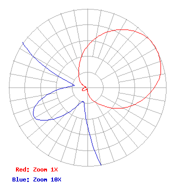 | |||||||||||||||||||||||||
| Azimuth | Ratio | Azimuth | Ratio | Azimuth | Ratio | Azimuth | Ratio | |||||||||||||||||||
| 0 | 0.525 | 10 | 0.640 | 20 | 0.750 | 30 | 0.849 | |||||||||||||||||||
| 40 | 0.932 | 50 | 0.987 | 60 | 1.000 | 70 | 0.983 | |||||||||||||||||||
| 80 | 0.939 | 90 | 0.850 | 100 | 0.745 | 110 | 0.634 | |||||||||||||||||||
| 120 | 0.521 | 130 | 0.405 | 140 | 0.296 | 150 | 0.223 | |||||||||||||||||||
| 160 | 0.165 | 170 | 0.101 | 180 | 0.049 | 190 | 0.023 | |||||||||||||||||||
| 200 | 0.019 | 210 | 0.028 | 220 | 0.045 | 230 | 0.064 | |||||||||||||||||||
| 240 | 0.077 | 250 | 0.071 | 260 | 0.051 | 270 | 0.028 | |||||||||||||||||||
| 280 | 0.017 | 290 | 0.035 | 300 | 0.080 | 310 | 0.125 | |||||||||||||||||||
| 320 | 0.168 | 330 | 0.224 | 340 | 0.304 | 350 | 0.409 | |||||||||||||||||||
Structure Registration Number 1047847 Structure Type: LTOWER Registered To: American Towers LLC Structure Address: Route 1, Box 114 Lafe, AR County Name: Clay County ASR Issued: 12/09/2016 Date Built: 03/14/1995 Site Elevation: 157.2 m (516 ft.) Structure Height: 91.4 m (300 ft.) Height Overall: 96.3 m (316 ft.) Overall Height AMSL: 253.5 m (832 ft.) FAA Determination: 07/20/2015 FAA Study #: 2015-ASW-1248-OE FAA Circular #: 70/7460-1H Paint & Light FAA Chapters: 4, 8, 13 PRIOR STUDY 2002-ASW-2139-OE 36-16-40.6 N 90-23-44.1 W (NAD 83) 36-16-40.4 N 90-23-43.7 W (Converted to NAD 27) |
4370 Peachtree Road, Ne Atlanta, GA 30319 Phone: 202-750-1585 Limited Liability Company | Title: Assistant Secretary Date: 01/10/2024 Application Certifier Gray Television Licensee, Llc 4370 Peachtree Road, Ne Atlanta, GA 30319 Applicant Joan Stewart Wiley Rein Llp 2050 M Street, Nw Washington, DC 20036 | ||||||||||||||||||||||||