
FCCInfo.com
A Service of Cavell, Mertz & Associates, Inc.
(855) FCC-INFO
|
|
WUNW from 09/19/1996 |
Virtual Channel 27 |  |
|
||||||||||||||||||||
|
|
Repacking Information: No changes Status: STA – Special Temporary Authority Application Accepted: 02/21/2024 STA Expires: 08/06/2024 File Number: -0000238132 FCC Website Links: LMS Facility Details This Application Other WUNW Applications Including Superseded Applications Mailing Address Correspondence for WUNW Correspondence related to application -0000238132 Service Contour - Open Street Map or USGS Map (41 dBu) Service Contour - KML / Google Earth (41 dBu) Public Inspection Files Rabbit Ears Info Search for WUNW DTS Site Number: 1 Site Location: 35-34-07.0 N 82-54-26.2 W (NAD 83) Site Location: 35-34-06.6 N 82-54-26.7 W (Converted to NAD 27) ERP: 115 kW Polarization: Elliptically polarized HAAT: 504.9 m (1656 ft.) Electrical Beam Tilt: 3 degrees R/C AGL: 55 m (180 ft.) R/C AMSL: 1421 m (4662 ft.) Site Elevation: 1366 m. (4482 ft.) Height Overall*: 59 m (194 ft.) (* As Filed In This Application, may differ from ASR Data, Below.) Directional Antenna - Antenna Make/Model: Dielectric TFU-10DSB/VP-B-R Antenna ID: 1011449 Polarization: Elliptically polarized
| |||||||||||||||||||||||
| Antenna Data for Antenna Id: 1011449 WUNW DD File: -0000238132 Dielectric - TFU-10DSB/VP-B-R Service: DD Standard Pattern: N | 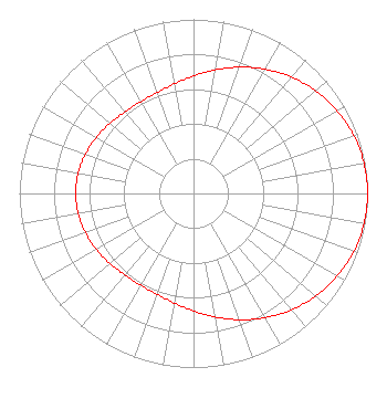 | |||||||||||||||||||||||
| Azimuth | Ratio | Azimuth | Ratio | Azimuth | Ratio | Azimuth | Ratio | |||||||||||||||||
| 0 | 0.675 | 10 | 0.721 | 20 | 0.772 | 30 | 0.824 | |||||||||||||||||
| 40 | 0.873 | 50 | 0.917 | 60 | 0.952 | 70 | 0.979 | |||||||||||||||||
| 80 | 0.995 | 90 | 1.000 | 100 | 0.995 | 110 | 0.979 | |||||||||||||||||
| 120 | 0.952 | 130 | 0.917 | 140 | 0.873 | 150 | 0.824 | |||||||||||||||||
| 160 | 0.772 | 170 | 0.721 | 180 | 0.675 | 190 | 0.639 | |||||||||||||||||
| 200 | 0.616 | 210 | 0.608 | 220 | 0.613 | 230 | 0.627 | |||||||||||||||||
| 240 | 0.644 | 250 | 0.660 | 260 | 0.672 | 270 | 0.676 | |||||||||||||||||
| 280 | 0.672 | 290 | 0.660 | 300 | 0.644 | 310 | 0.627 | |||||||||||||||||
| 320 | 0.613 | 330 | 0.608 | 340 | 0.616 | 350 | 0.639 | |||||||||||||||||
Structure Registration Number 1275765 Structure Type: TOWER Registered To: University of North Carolina Structure Address: Atop Chambers Mountain, Lookout Tower Road Clyde, NC County Name: Haywood County ASR Issued: 09/01/2010 Date Built: 06/03/2011 Site Elevation: 1366 m (4482 ft.) Structure Height: 59 m (194 ft.) Height Overall: 59 m (194 ft.) Overall Height AMSL: 1425 m (4675 ft.) FAA Determination: 08/31/2010 FAA Study #: 2010-ASO-4238-OE Paint & Light FAA Chapters: NONE Removed expiration date from determination. Scenario 1./jjs/case#635066 35-34-07.0 N 82-54-26.2 W (NAD 83) 35-34-06.6 N 82-54-26.7 W (Converted to NAD 27) |
10 Unc-tv Drive Research Triangle Park, NC 27709 Phone: 919-549-7000 Government Entity | Title: Chief Executive Officer Date: 02/02/2024 Application Certifier University of North Carolina University Of North Carolina 10 Unc-tv Drive Research Triangle Park, NC 27709 Applicant Patrick Cross Brooks, Pierce Et Al. 150 Fayetteville Street Suite 1700 Raleigh, NC 27601 Donald W Smith University Of North Carolina 10 Unc-tv Drive Research Triangle Park, NC 27709 Marcus W Trathen Brooks, Pierce Et Al. 150 Fayetteville Street Suite 1700 Raleigh, NC 27601 | ||||||||||||||||||||||