
FCCInfo.com
A Service of Cavell, Mertz & Associates, Inc.
(855) FCC-INFO
|
|
W16EE-D from 01/30/2012 |
|
|
|||||||||||||||||||||||
|
|
Status: License Application Accepted: 02/09/2024 License Expires: 04/01/2029 File Number: -0000238634 FCC Website Links: LMS Facility Details This Application Other W16EE-D Applications Including Superseded Applications Mailing Address Correspondence for W16EE-D Correspondence related to application -0000238634 Service Contour - Open Street Map or USGS Map (51 dBu) Service Contour - KML / Google Earth (51 dBu) Rabbit Ears Info Search for W16EE-D Site Location: 33-30-21.0 N 81-57-43.0 W (NAD 83) Site Location: 33-30-20.5 N 81-57-43.6 W (Converted to NAD 27) ERP: 15 kW Polarization: Elliptically polarized Electrical Beam Tilt: 1 degree R/C AGL: 125 m (410 ft.) R/C AMSL: 268.6 m (881 ft.) Emission Mask: Full Service Site Elevation: 143.6 m. (471 ft.) Height Overall*: 152.7 m (501 ft.) (* As Filed In This Application, may differ from ASR Data, Below.) Directional Antenna - Antenna Make/Model: DIELECTRIC DLP12-B Antenna ID: 1002083 Polarization: Elliptically polarized
| |||||||||||||||||||||||||
| Antenna Data for Antenna Id: 1002083 W16EE-D LD File: -0000238634 DIELECTRIC - DLP12-B Service: LD Standard Pattern: Y Pattern and Field Values Include a 340° Clockwise Rotation | 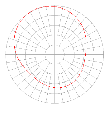 | |||||||||||||||||||||||||
| Azimuth | Ratio | Azimuth | Ratio | Azimuth | Ratio | Azimuth | Ratio | |||||||||||||||||||
| 0 | 0.979 | 10 | 0.953 | 20 | 0.918 | 30 | 0.875 | |||||||||||||||||||
| 40 | 0.828 | 50 | 0.778 | 60 | 0.729 | 70 | 0.686 | |||||||||||||||||||
| 80 | 0.653 | 90 | 0.633 | 100 | 0.627 | 110 | 0.632 | |||||||||||||||||||
| 120 | 0.646 | 130 | 0.662 | 140 | 0.678 | 150 | 0.689 | |||||||||||||||||||
| 160 | 0.692 | 170 | 0.689 | 180 | 0.678 | 190 | 0.662 | |||||||||||||||||||
| 200 | 0.646 | 210 | 0.632 | 220 | 0.627 | 230 | 0.633 | |||||||||||||||||||
| 240 | 0.653 | 250 | 0.686 | 260 | 0.729 | 270 | 0.778 | |||||||||||||||||||
| 280 | 0.828 | 290 | 0.875 | 300 | 0.918 | 310 | 0.953 | |||||||||||||||||||
| 320 | 0.979 | 330 | 0.995 | 340 | 1.000 | 350 | 0.995 | |||||||||||||||||||
Structure Registration Number 1059412 Structure Type: LTOWER Registered To: Subcarrier Communications, Inc. Structure Address: 1301 Georgia Ave North Augusta, SC County Name: Aiken County ASR Issued: 01/30/2024 Date Built: 01/01/1998 Site Elevation: 143.6 m (471 ft.) Structure Height: 129.5 m (425 ft.) Height Overall: 152.7 m (501 ft.) Overall Height AMSL: 296.3 m (972 ft.) FAA Determination: 01/29/2024 FAA Study #: 2023-ASO-23983-OE FAA Circular #: 70/7460-1M Paint & Light FAA Chapters: 4, 8, 15 PRIOR STUDY 1989-ASO-981-OE 33-30-21.0 N 81-57-43.0 W (NAD 83) 33-30-20.5 N 81-57-43.6 W (Converted to NAD 27) |
14 Tuxedo Drive Beaufort, SC 29907 Phone: 717-226-3535 Limited Liability Company | Title: Manager Date: 02/09/2024 Application Certifier Lowcountry 34 Media, Llc 14 Tuxedo Drive Beaufort, SC 29907 Applicant Davina S Sashkin, Esq Wilkinson Barker Knauer, Llp 1800 M Street, Nw Suite 800n Washington, DC 20036 | ||||||||||||||||||||||||