
FCCInfo.com
A Service of Cavell, Mertz & Associates, Inc.
(855) FCC-INFO
|
|
WYJH-LD from 11/10/2009 WYJH-LD from 06/19/1990 |
|
|
||||||||||||||||
|
|
Status: STA – Special Temporary Authority (Licensed And Silent) Application Accepted: 02/14/2024 STA Expires: 00/00/0000 File Number: -0000237205 FCC Website Links: LMS Facility Details This Application Other WYJH-LD Applications Including Superseded Applications Mailing Address Correspondence for WYJH-LD Correspondence related to application -0000237205 Service Contour - Open Street Map or USGS Map (51 dBu) Service Contour - KML / Google Earth (51 dBu) Rabbit Ears Info Search for WYJH-LD Site Location: 41-29-36.7 N 73-25-43.9 W (NAD 83) Site Location: 41-29-36.4 N 73-25-45.5 W (Converted to NAD 27) ERP: 15 kW Polarization: Elliptically polarized Electrical Beam Tilt: 0.75 degrees R/C AGL: 138.2 m (453 ft.) R/C AMSL: 356.7 m (1170 ft.) Emission Mask: Full Service Site Elevation: 218.5 m. (717 ft.) Height Overall*: 152.1 m (499 ft.) (* As Filed In This Application, may differ from ASR Data, Below.) Directional Antenna - Antenna Make/Model: ATC BCE310C1W-V4-27 Antenna ID: 1010891 Polarization: Elliptically polarized | ||||||||||||||||||
| Antenna Data for Antenna Id: 1010891 WYJH-LD LD File: -0000237205 ATC - BCE310C1W-V4-27 Service: LD Standard Pattern: Y | 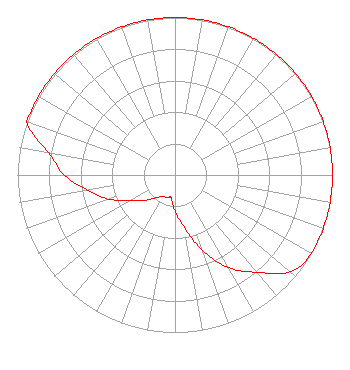 | ||||||||||||||||||
| Azimuth | Ratio | Azimuth | Ratio | Azimuth | Ratio | Azimuth | Ratio | ||||||||||||
| 0 | 1.000 | 10 | 1.000 | 20 | 1.000 | 30 | 1.000 | ||||||||||||
| 40 | 1.000 | 50 | 1.000 | 60 | 1.000 | 70 | 1.000 | ||||||||||||
| 80 | 1.000 | 90 | 1.000 | 100 | 1.000 | 110 | 1.000 | ||||||||||||
| 120 | 1.000 | 130 | 0.957 | 140 | 0.808 | 150 | 0.680 | ||||||||||||
| 160 | 0.510 | 170 | 0.335 | 180 | 0.230 | 190 | 0.146 | ||||||||||||
| 200 | 0.155 | 210 | 0.155 | 220 | 0.189 | 230 | 0.250 | ||||||||||||
| 240 | 0.318 | 250 | 0.447 | 260 | 0.559 | 270 | 0.703 | ||||||||||||
| 280 | 0.815 | 290 | 1.000 | 300 | 1.000 | 310 | 1.000 | ||||||||||||
| 320 | 1.000 | 330 | 1.000 | 340 | 1.000 | 350 | 1.000 | ||||||||||||
Structure Registration Number 1045933 Structure Type: GTOWER Registered To: VB-S1 Assets, LLC Structure Address: 0.3 Mi. Sse Of Intersection Of Carmen Hill Rd & Se Trail Brookfield, CT County Name: Fairfield County ASR Issued: 01/30/2018 Date Built: 01/01/1996 Site Elevation: 218.5 m (717 ft.) Structure Height: 151.2 m (496 ft.) Height Overall: 152.1 m (499 ft.) Overall Height AMSL: 370.6 m (1216 ft.) FAA Determination: 01/13/2016 FAA Study #: 2016-ANE-12-OE FAA Circular #: 70/7460-1L Paint & Light FAA Chapters: 4, 8, 12 PRIOR STUDY 2009-ANE-1283-OE 41-29-36.7 N 73-25-43.9 W (NAD 83) 41-29-36.4 N 73-25-45.5 W (Converted to NAD 27) |
500 Summer Street #502 Stamford, CT 06901 Phone: 917-817-3010 Limited Liability Company | Title: Managing Member Date: 02/14/2024 Application Certifier Egot Media, Llc 500 Summer Street #502 Stamford, CT 06901 Applicant Mark Denbo Smithwick & Belendiuk, P.c. 5028 Wisconsin Avenue, N.w. Suite 301 Washington, DC 20016 Counsel Clarence M Beverage Communications Technologies 23 Binsted Drive Medford, NJ 08055 Broadcast Engineering Consultant | |||||||||||||||||