
FCCInfo.com
A Service of Cavell, Mertz & Associates, Inc.
(855) FCC-INFO
|
|
|
Virtual Channel 2 |  |
|
|||||||||||||||
|
|
Repacking Information: No changes Status: License Application Accepted: 03/04/2024 License Expires: 04/01/2030 File Number: -0000240307 FCC Website Links: LMS Facility Details This Application Other KGFE Applications Including Superseded Applications Mailing Address Correspondence for KGFE Correspondence related to application -0000240307 Service Contour - Open Street Map or USGS Map (41 dBu) Service Contour - KML / Google Earth (41 dBu) Public Inspection Files History Cards for KGFE Rabbit Ears Info Search for KGFE Site Location: 47-58-33.7 N 96-36-15.9 W (NAD 83) Site Location: 47-58-33.8 N 96-36-14.7 W (Converted to NAD 27) ERP: 22.6 kW Polarization: Horizontally polarized HAAT: 186.1 m (611 ft.) Electrical Beam Tilt: 0.5 degrees R/C AGL: 185.9 m (610 ft.) R/C AMSL: 461.7 m (1515 ft.) Site Elevation: 275.8 m. (905 ft.) Height Overall*: 228.6 m (750 ft.) (* As Filed In This Application, may differ from ASR Data, Below.) Directional Antenna - Antenna Make/Model: Electronics Research Inc. ALP16L2-HSW-15 Antenna ID: 89463 Polarization: Horizontally polarized | ||||||||||||||||||
| Antenna Data for Antenna Id: 89463 KGFE DT File: -0000240307 Electronics Research Inc. - ALP16L2-HSW-15 Service: DT Standard Pattern: Y Pattern and Field Values Include a 260° Clockwise Rotation | 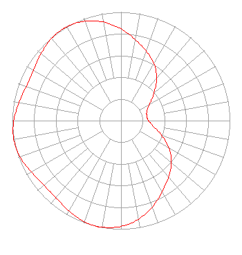 | ||||||||||||||||||
| Azimuth | Ratio | Azimuth | Ratio | Azimuth | Ratio | Azimuth | Ratio | ||||||||||||
| 0 | 0.845 | 10 | 0.758 | 20 | 0.680 | 30 | 0.605 | ||||||||||||
| 40 | 0.510 | 50 | 0.397 | 60 | 0.302 | 70 | 0.253 | ||||||||||||
| 80 | 0.241 | 90 | 0.253 | 100 | 0.302 | 110 | 0.397 | ||||||||||||
| 120 | 0.510 | 130 | 0.605 | 140 | 0.680 | 150 | 0.758 | ||||||||||||
| 160 | 0.845 | 170 | 0.922 | 180 | 0.975 | 190 | 0.997 | ||||||||||||
| 193 | 1.000 | 200 | 0.990 | 210 | 0.959 | 220 | 0.929 | ||||||||||||
| 230 | 0.925 | 240 | 0.951 | 250 | 0.985 | 260 | 1.000 | ||||||||||||
| 270 | 0.985 | 280 | 0.951 | 290 | 0.925 | 300 | 0.929 | ||||||||||||
| 310 | 0.959 | 320 | 0.990 | 327 | 1.000 | 330 | 0.997 | ||||||||||||
| 340 | 0.975 | 350 | 0.922 | ||||||||||||||||
Structure Registration Number 1227695 Structure Type: GTOWER Registered To: Prairie Public Broadcasting, Inc. Structure Address: .6 Km N And 2.6 Km E Euclid, MN County Name: Polk County ASR Issued: 01/23/2024 Date Built: 01/23/2024 Site Elevation: 275.8 m (905 ft.) Structure Height: 213.2 m (699 ft.) Height Overall: 228.6 m (750 ft.) Overall Height AMSL: 504.4 m (1655 ft.) FAA Determination: 11/08/2023 FAA Study #: 2023-AGL-21533-OE FAA Circular #: 70/7460-1K Paint & Light FAA Chapters: 3, 4, 5, 12 OM&L to remain the same as prior study = PAINT/RED LIGHTS 47-58-33.7 N 96-36-15.9 W (NAD 83) 47-58-33.8 N 96-36-14.7 W (Converted to NAD 27) |
Fargo, ND 58108 Phone: 701-241-6900 Not-for-Profit | Title: President And Ceo Date: 03/04/2024 Application Certifier Prairie Public Broadcasting, Inc. Fargo, ND 58108 Applicant Jack W. Anderson Prairie Public Broadcasting, Inc. Fargo, ND 58108 Director of Engineering Dane Ericksen, P.E. Hammett & Edison, Inc. 470 Third Street West Sonoma, CA 95476 Consulting Engineer Barry S. Persh Gray Miller Persh Llp 2233 Wisconsin Ave., Nw Suite 226 Washington, DC 20007 | |||||||||||||||||