
FCCInfo.com
A Service of Cavell, Mertz & Associates, Inc.
(855) FCC-INFO
|
|
K15CX-D from 09/27/1989 |
|
|
||||||||||||||||
|
|
Status: Construction Permit Application Accepted: 03/25/2024 K15CX-D CP Expires: 03/26/2027 File Number: -0000242016 FCC Website Links: LMS Facility Details This Application Other K15CX-D Applications Including Superseded Applications Mailing Address Correspondence for K15CX-D Correspondence related to application -0000242016 Service Contour - Open Street Map or USGS Map (51 dBu) Service Contour - KML / Google Earth (51 dBu) Rabbit Ears Info Search for K15CX-D Site Location: 39-27-46.0 N 121-34-53.0 W (NAD 83) Site Location: 39-27-46.4 N 121-34-49.1 W (Converted to NAD 27) ERP: 5 kW Polarization: Circularly polarized R/C AGL: 20.7 m (68 ft.) R/C AMSL: 93.2 m (306 ft.) Emission Mask: Simple Site Elevation: 72.5 m. (238 ft.) Height Overall*: 30.5 m (100 ft.) (* As Filed In This Application, may differ from ASR Data, Below.) Directional Antenna - Antenna Make/Model: Dielectric TUM-C1-2/2 Antenna ID: 1011590 Polarization: Circularly polarized
| ||||||||||||||||||
| Antenna Data for Antenna Id: 1011590 K15CX-D LD File: -0000242016 Dielectric - TUM-C1-2/2 Service: LD Standard Pattern: N | 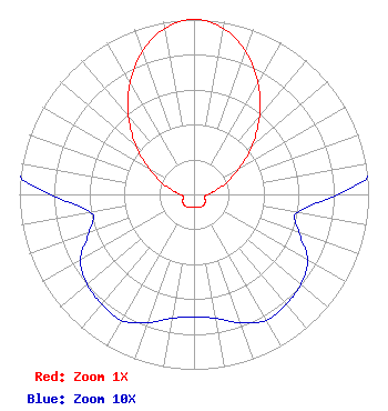 | ||||||||||||||||||
| Azimuth | Ratio | Azimuth | Ratio | Azimuth | Ratio | Azimuth | Ratio | ||||||||||||
| 0 | 1.000 | 10 | 0.964 | 20 | 0.868 | 30 | 0.733 | ||||||||||||
| 40 | 0.584 | 50 | 0.435 | 60 | 0.296 | 70 | 0.198 | ||||||||||||
| 80 | 0.123 | 90 | 0.082 | 100 | 0.060 | 110 | 0.064 | ||||||||||||
| 120 | 0.075 | 130 | 0.080 | 140 | 0.082 | 150 | 0.083 | ||||||||||||
| 160 | 0.078 | 170 | 0.072 | 180 | 0.070 | 190 | 0.072 | ||||||||||||
| 200 | 0.078 | 210 | 0.083 | 220 | 0.082 | 230 | 0.080 | ||||||||||||
| 240 | 0.075 | 250 | 0.064 | 260 | 0.060 | 270 | 0.082 | ||||||||||||
| 280 | 0.123 | 290 | 0.198 | 300 | 0.296 | 310 | 0.435 | ||||||||||||
| 320 | 0.584 | 330 | 0.733 | 340 | 0.868 | 350 | 0.964 | ||||||||||||
Structure Registration Number 1063515 Structure Type: TOWER Registered To: Sinclair Television of California, LLC Structure Address: Hwy 70 Approx 5 Km Sw Oroville, CA County Name: Butte County ASR Issued: 03/05/2024 Date Built: 08/01/1999 Site Elevation: 72.5 m (238 ft.) Structure Height: 30.5 m (100 ft.) Height Overall: 30.5 m (100 ft.) Overall Height AMSL: 103 m (338 ft.) FAA Determination: 04/02/1999 FAA Study #: 99-AWP-0302-OE Paint & Light FAA Chapters: NONE 39-27-46.0 N 121-34-53.0 W (NAD 83) 39-27-46.4 N 121-34-49.1 W (Converted to NAD 27) |
10706 Beaver Dam Road Cockeysville, MD 21030 Phone: 410-568-1500 Limited Liability Company | Title: Cfo Date: 03/25/2024 Application Certifier Sinclair Media Licensee, LLC Sinclair Media Licensee, Llc 10706 Beaver Dam Road Cockeysville, MD 21030 Applicant Carl E Gluck Carl T Jones Corp 7901 Yarnwood Court Springfield, VA 22153 Technical Consultant Paul A. Cicelski Lerman Senter Pllc 2001 L St. Nw Suite 400 Washington, DC 20036 | |||||||||||||||||