
FCCInfo.com
A Service of Cavell, Mertz & Associates, Inc.
(855) FCC-INFO
|
|
from 07/11/2022 from 01/31/2019 from 06/19/2002 from 04/13/1989 |
|
|
||||||||||||||||
|
|
Status: STA – Special Temporary Authority (Licensed And Silent) Application Accepted: 03/15/2024 STA Expires: 08/12/2024 File Number: -0000241065 FCC Website Links: LMS Facility Details This Application Other KBIT-LD Applications Including Superseded Applications Mailing Address Correspondence for KBIT-LD Correspondence related to application -0000241065 Service Contour - Open Street Map or USGS Map (51 dBu) Service Contour - KML / Google Earth (51 dBu) Rabbit Ears Info Search for KBIT-LD Site Location: 37-03-28.0 N 121-46-34.0 W (NAD 83) Site Location: 37-03-28.2 N 121-46-30.2 W (Converted to NAD 27) ERP: 15 kW Polarization: Horizontally polarized R/C AGL: 152.4 m (500 ft.) R/C AMSL: 913.5 m (2997 ft.) Emission Mask: Full Service Site Elevation: 761.1 m. (2497 ft.) Height Overall*: 473.1 m (1552 ft.) (* As Filed In This Application, may differ from ASR Data, Below.) Directional Antenna - Antenna Make/Model: Scala 4X2KBBU Antenna ID: 59092 Polarization: Horizontally polarized | ||||||||||||||||||
| Antenna Data for Antenna Id: 59092 KBIT-LD LD File: -0000241065 Scala - 4X2KBBU Service: LD Standard Pattern: Y Pattern and Field Values Include a 245° Clockwise Rotation | 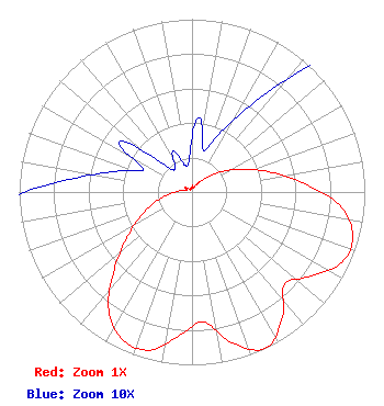 | ||||||||||||||||||
| Azimuth | Ratio | Azimuth | Ratio | Azimuth | Ratio | Azimuth | Ratio | ||||||||||||
| 5 | 0.043 | 15 | 0.025 | 25 | 0.037 | 35 | 0.064 | ||||||||||||
| 45 | 0.114 | 55 | 0.205 | 65 | 0.314 | 75 | 0.456 | ||||||||||||
| 85 | 0.638 | 95 | 0.855 | 105 | 0.963 | 115 | 0.960 | ||||||||||||
| 125 | 0.843 | 135 | 0.759 | 145 | 0.907 | 155 | 1.000 | ||||||||||||
| 165 | 0.904 | 175 | 0.754 | 185 | 0.833 | 195 | 0.947 | ||||||||||||
| 205 | 0.946 | 215 | 0.840 | 225 | 0.637 | 235 | 0.462 | ||||||||||||
| 245 | 0.324 | 255 | 0.219 | 265 | 0.128 | 275 | 0.075 | ||||||||||||
| 285 | 0.046 | 295 | 0.031 | 305 | 0.051 | 315 | 0.021 | ||||||||||||
| 325 | 0.017 | 335 | 0.026 | 345 | 0.016 | 355 | 0.019 | ||||||||||||
Structure Registration Number 1018359 Structure Type: TOWER Registered To: Mount Madonna Tower Owners Association Structure Address: Approx 9 Mi N Watsonville, CA County Name: Santa Clara County ASR Issued: 06/29/2009 Date Built: 01/01/1984 Site Elevation: 761.1 m (2497 ft.) Structure Height: 449.3 m (1474 ft.) Height Overall: 473.1 m (1552 ft.) Overall Height AMSL: 1234.2 m (4049 ft.) FAA Determination: 03/25/1997 FAA Study #: 97-AWP-0690-OE Paint & Light FAA Chapters: A1, B, F, H, 3, 10, 19, 21, 23 DUAL HIGH INTENSITY LIGHTS. 37-03-28.0 N 121-46-34.0 W (NAD 83) 37-03-28.2 N 121-46-30.2 W (Converted to NAD 27) |
2383 Pruneridge Avenue Suite 4 Santa Clara, CA 95050 Phone: 415-886-7284 Corporation | Title: President Date: 03/15/2024 Application Certifier Major Market Broadcasting Of California, Inc. 2383 Pruneridge Avenue Suite 4 Santa Clara, CA 95050 Applicant Dennis P. Corbett Telecommunications Law Professionals Pllc 1025 Connecticut Ave Suite 1011 Washington, DC 20036 | |||||||||||||||||
| |||||||||||||||||||