
FCCInfo.com
A Service of Cavell, Mertz & Associates, Inc.
(855) FCC-INFO
|
|
WCWF from 06/09/1999 WCWF from 01/13/1998 WCWF from 11/16/1981 |
Post-repack Channel 15 Virtual Channel 14 |  |
|
||||||||||||||||
|
|
Repacking Information: Pre-Repack Channel: 21 Post-Repack Channel: 15 Post-Repack ERP: 692 kW Phase: 9 Completion Deadline: 5/1/2020 Find nearby TV Facilities Status: License Application Accepted: 03/21/2024 License Expires: 12/01/2021 File Number: -0000241677 FCC Website Links: LMS Facility Details This Application Other WCWF Applications Including Superseded Applications Mailing Address Correspondence for WCWF Correspondence related to application -0000241677 Service Contour - Open Street Map or USGS Map (41 dBu) Service Contour - KML / Google Earth (41 dBu) Public Inspection Files Rabbit Ears Info Search for WCWF Site Location: 44-24-32.0 N 87-59-31.0 W (NAD 83) Site Location: 44-24-32.0 N 87-59-30.6 W (Converted to NAD 27) ERP: 600 kW Polarization: Elliptically polarized HAAT: 360 m (1181 ft.) Electrical Beam Tilt: 0.75 degrees R/C AGL: 319 m (1047 ft.) R/C AMSL: 589.7 m (1935 ft.) Site Elevation: 270.7 m. (888 ft.) Height Overall*: 353 m (1158 ft.) (* As Filed In This Application, may differ from ASR Data, Below.) Directional Antenna - Antenna Make/Model: Dielectric TFU-24DSC/VP-R C170 Antenna ID: 1011575 Polarization: Elliptically polarized | |||||||||||||||||||
| Antenna Data for Antenna Id: 1011575 WCWF DT File: -0000241677 Dielectric - TFU-24DSC/VP-R C170 Service: DT Standard Pattern: N Pattern and Field Values Include a 65° Clockwise Rotation | 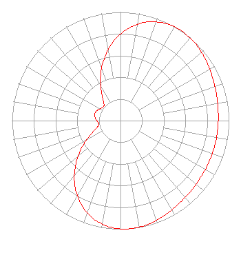 | |||||||||||||||||||
| Azimuth | Ratio | Azimuth | Ratio | Azimuth | Ratio | Azimuth | Ratio | |||||||||||||
| 5 | 0.854 | 15 | 0.940 | 25 | 0.987 | 35 | 1.000 | |||||||||||||
| 45 | 0.988 | 55 | 0.963 | 65 | 0.936 | 75 | 0.917 | |||||||||||||
| 85 | 0.905 | 95 | 0.900 | 105 | 0.899 | 115 | 0.900 | |||||||||||||
| 125 | 0.905 | 135 | 0.917 | 145 | 0.936 | 155 | 0.963 | |||||||||||||
| 165 | 0.988 | 175 | 1.000 | 185 | 0.987 | 195 | 0.940 | |||||||||||||
| 205 | 0.854 | 215 | 0.733 | 225 | 0.588 | 235 | 0.437 | |||||||||||||
| 245 | 0.302 | 255 | 0.218 | 260 | 0.204 | 265 | 0.207 | |||||||||||||
| 275 | 0.232 | 285 | 0.245 | 295 | 0.232 | 305 | 0.207 | |||||||||||||
| 310 | 0.204 | 315 | 0.218 | 325 | 0.302 | 335 | 0.437 | |||||||||||||
| 345 | 0.588 | 355 | 0.733 | |||||||||||||||||
Structure Registration Number 1064113 Structure Type: TOWER Registered To: WLUK Licensee, LLC Structure Address: 5111 Video Lane Ledgeview Township, WI County Name: Brown County ASR Issued: 01/11/2017 Date Built: 06/01/1961 Site Elevation: 270.7 m (888 ft.) Structure Height: 329.9 m (1082 ft.) Height Overall: 353 m (1158 ft.) Overall Height AMSL: 623.7 m (2046 ft.) FAA Determination: 01/20/1998 FAA Study #: 97-AGL-5517-OE FAA Circular #: 70/7460-1J Paint & Light FAA Chapters: 3, 4, 5, 13 44-24-32.0 N 87-59-31.0 W (NAD 83) 44-24-32.0 N 87-59-30.6 W (Converted to NAD 27) |
10706 Beaver Dam Road Cockeysville, MD 21030 Phone: 410-568-1500 Limited Liability Company | Title: Cfo Date: 03/21/2024 Application Certifier Wcwf Licensee, Llc 10706 Beaver Dam Road Cockeysville, MD 21030 Applicant Paul A. Cicelski, Esq Lerman Senter Pllc 2001 L. Street Nw Suite 400 Washington, DC 20036 Legal Representative John E. Hidle, PE Carl T. Jones Corporation 7901 Yarnwood Court Springfield, VA 22153 Consulting Engineer | ||||||||||||||||||
| ||||||||||||||||||||
