
FCCInfo.com
A Service of Cavell, Mertz & Associates, Inc.
(855) FCC-INFO
|
|
WHWV-LD from 12/01/2000 WHWV-LD from 09/07/1999 WHWV-LD from 03/10/1999 |
|
|
|||||||||||||||||
|
|
Status: Construction Permit Application Accepted: 03/21/2024 WHWV-LD CP Expires: 10/11/2026 File Number: -0000241612 FCC Website Links: LMS Facility Details This Application Other WHWV-LD Applications Including Superseded Applications Mailing Address Correspondence for WHWV-LD Correspondence related to application -0000241612 Service Contour - Open Street Map or USGS Map (51 dBu) Service Contour - KML / Google Earth (51 dBu) Rabbit Ears Info Search for WHWV-LD Site Location: 38-30-36.3 N 82-13-09.5 W (NAD 83) Site Location: 38-30-36.0 N 82-13-10.0 W (Converted to NAD 27) ERP: 15 kW Polarization: Horizontally polarized Electrical Beam Tilt: 0.75 degrees R/C AGL: 151.8 m (498 ft.) R/C AMSL: 460 m (1509 ft.) Emission Mask: Full Service Site Elevation: 308.2 m. (1011 ft.) Height Overall*: 313.9 m (1030 ft.) (* As Filed In This Application, may differ from ASR Data, Below.) Directional Antenna - Antenna Make/Model: Propagation System Inc PSILP16OI Antenna ID: 1011571 Polarization: Horizontally polarized
| |||||||||||||||||||
| Antenna Data for Antenna Id: 1011571 WHWV-LD LD File: -0000241612 Propagation System Inc - PSILP16OI Service: LD Standard Pattern: N Pattern and Field Values Include a 270° Clockwise Rotation | 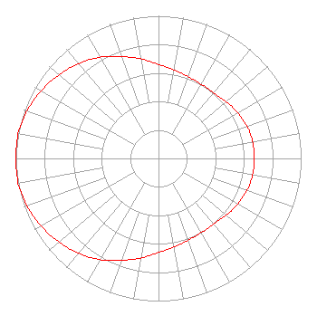 | |||||||||||||||||||
| Azimuth | Ratio | Azimuth | Ratio | Azimuth | Ratio | Azimuth | Ratio | |||||||||||||
| 0 | 0.660 | 10 | 0.630 | 20 | 0.610 | 30 | 0.600 | |||||||||||||
| 40 | 0.600 | 50 | 0.620 | 60 | 0.640 | 70 | 0.660 | |||||||||||||
| 80 | 0.670 | 90 | 0.670 | 100 | 0.670 | 110 | 0.660 | |||||||||||||
| 120 | 0.640 | 130 | 0.620 | 140 | 0.600 | 150 | 0.600 | |||||||||||||
| 160 | 0.610 | 170 | 0.630 | 180 | 0.660 | 190 | 0.710 | |||||||||||||
| 200 | 0.760 | 210 | 0.820 | 220 | 0.870 | 230 | 0.910 | |||||||||||||
| 240 | 0.950 | 250 | 0.980 | 260 | 1.000 | 270 | 1.000 | |||||||||||||
| 280 | 1.000 | 290 | 0.980 | 300 | 0.950 | 310 | 0.910 | |||||||||||||
| 320 | 0.870 | 330 | 0.820 | 340 | 0.760 | 350 | 0.710 | |||||||||||||
Structure Registration Number 1035121 Structure Type: GTOWER Registered To: Gray Media Group, Inc. Structure Address: 8908 Barker Ridge Road Ona, WV County Name: Cabell County ASR Issued: 09/09/2020 Date Built: 10/27/2014 Site Elevation: 308.2 m (1011 ft.) Structure Height: 294.5 m (966 ft.) Height Overall: 313.9 m (1030 ft.) Overall Height AMSL: 622.1 m (2041 ft.) FAA Determination: 10/22/2014 FAA Study #: 2014-AEA-5451-OE FAA Circular #: 70/7460-1K Paint & Light FAA Chapters: 3, 4, 5, 12 PRIOR STUDY 1999-AEA-3344-OE 38-30-36.3 N 82-13-09.5 W (NAD 83) 38-30-36.0 N 82-13-10.0 W (Converted to NAD 27) |
Po Box 11409 Chattanooga, TN 37401 Phone: 423-468-5100 Limited Liability Company | Title: Coo Date: 03/21/2024 Application Certifier DIGITAL NETWORKS-NORTHEAST, LLC Digital Networks-northeast, Llc Po Box 11409 Chattanooga, TN 37401 Applicant Timothy Z Sawyer T Z Sawyer Technical Consultants 2130 Hutchison Grove Court Suite 100 Falls Church, VA 22043 Technical Consultant Aaron P Shainis Shainis & Peltzman, Chartered 1850 M St. Nw Suite 240 Washington, DC 20036 FCC Legal Counsel | ||||||||||||||||||