
FCCInfo.com
A Service of Cavell, Mertz & Associates, Inc.
(855) FCC-INFO
|
|
W36FK-D from 02/26/2013 W36FK-D from 09/30/1992 W36FK-D from 08/15/1991 W36FK-D from 05/22/1991 |
|
|
|||||||||||||||||
|
|
Status: Construction Permit Application Accepted: 03/21/2024 W36FK-D CP Expires: 02/28/2026 File Number: -0000241614 FCC Website Links: LMS Facility Details This Application Other W36FK-D Applications Including Superseded Applications Mailing Address Correspondence for W36FK-D Correspondence related to application -0000241614 Service Contour - Open Street Map or USGS Map (51 dBu) Service Contour - KML / Google Earth (51 dBu) Rabbit Ears Info Search for W36FK-D Site Location: 40-47-22.3 N 79-09-47.4 W (NAD 83) Site Location: 40-47-22.1 N 79-09-48.3 W (Converted to NAD 27) ERP: 3 kW Polarization: Horizontally polarized R/C AGL: 45 m (148 ft.) R/C AMSL: 477.5 m (1567 ft.) Emission Mask: Full Service Site Elevation: 432.5 m. (1419 ft.) Height Overall*: 86.9 m (285 ft.) (* As Filed In This Application, may differ from ASR Data, Below.) Directional Antenna - Antenna Make/Model: Scala PRTV 110/345 Antenna ID: 1011573 Polarization: Horizontally polarized
| |||||||||||||||||||
| Antenna Data for Antenna Id: 1011573 W36FK-D LD File: -0000241614 Scala - PRTV 110/345 Service: LD Standard Pattern: N Pattern and Field Values Include a 110° Clockwise Rotation | 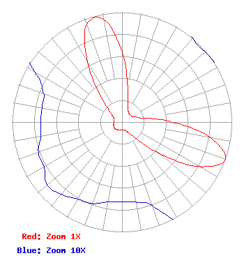 | |||||||||||||||||||
| Azimuth | Ratio | Azimuth | Ratio | Azimuth | Ratio | Azimuth | Ratio | |||||||||||||
| 0 | 0.638 | 10 | 0.302 | 20 | 0.160 | 30 | 0.114 | |||||||||||||
| 40 | 0.100 | 50 | 0.099 | 60 | 0.104 | 70 | 0.132 | |||||||||||||
| 80 | 0.203 | 90 | 0.455 | 100 | 0.819 | 110 | 1.000 | |||||||||||||
| 120 | 0.812 | 130 | 0.445 | 140 | 0.186 | 150 | 0.112 | |||||||||||||
| 160 | 0.081 | 170 | 0.074 | 180 | 0.073 | 190 | 0.074 | |||||||||||||
| 200 | 0.079 | 210 | 0.081 | 220 | 0.086 | 230 | 0.089 | |||||||||||||
| 240 | 0.082 | 250 | 0.081 | 260 | 0.075 | 270 | 0.074 | |||||||||||||
| 280 | 0.074 | 290 | 0.076 | 300 | 0.092 | 310 | 0.142 | |||||||||||||
| 320 | 0.288 | 330 | 0.631 | 340 | 0.942 | 350 | 0.947 | |||||||||||||
Structure Registration Number 1277720 Structure Type: LTOWER Registered To: American Towers LLC Structure Address: 20 Whitesell Road (283398) Home, PA County Name: Indiana County ASR Issued: 02/05/2015 Date Built: 07/22/2011 Site Elevation: 432.5 m (1419 ft.) Structure Height: 85.3 m (280 ft.) Height Overall: 86.9 m (285 ft.) Overall Height AMSL: 519.4 m (1704 ft.) FAA Determination: 11/18/2014 FAA Study #: 2014-AEA-7071-OE FAA Circular #: 70/7460-1K Paint & Light FAA Chapters: 4, 8, 12 PRIOR STUDY 2010-AEA-3400-OE 40-47-22.3 N 79-09-47.4 W (NAD 83) 40-47-22.1 N 79-09-48.3 W (Converted to NAD 27) |
Chattanooga, TN 37401 Phone: 423-468-5100 Limited Liability Company | Title: Coo Date: 03/21/2024 Application Certifier Digital Networks-Northeast, LLC Digital Networks-northeast, Llc Chattanooga, TN 37401 Applicant Timothy Z Sawyer T Z Sawyer Technical Consultants 2130 Hutchison Grove Court Suite 100 Falls Church, VA 22043 Technical Consultant Aaron P Shainis, Esq Shainis & Peltzman, Chartered 1850 M Street Nw Suite 240 Washington, DC 20036 FCC Legal Counsel | ||||||||||||||||||