
FCCInfo.com
A Service of Cavell, Mertz & Associates, Inc.
(855) FCC-INFO
|
|
W34FW-D from 06/24/2021 W34FW-D from 05/17/2011 |
|
|
||||||||||||||||
|
|
Status: License Application Accepted: 03/22/2024 License Expires: 02/01/2029 File Number: -0000241814 FCC Website Links: LMS Facility Details This Application Other WTGB-LD Applications Including Superseded Applications Mailing Address Correspondence for WTGB-LD Correspondence related to application -0000241814 Service Contour - Open Street Map or USGS Map (51 dBu) Service Contour - KML / Google Earth (51 dBu) Rabbit Ears Info Search for WTGB-LD Site Location: 29-32-12.0 N 82-23-59.0 W (NAD 83) Site Location: 29-32-11.1 N 82-23-59.6 W (Converted to NAD 27) ERP: 15 kW Polarization: Elliptically polarized Electrical Beam Tilt: 1.0 degree R/C AGL: 207.3 m (680 ft.) R/C AMSL: 226.8 m (744 ft.) Emission Mask: Full Service Site Elevation: 19.5 m. (64 ft.) Height Overall*: 299.5 m (983 ft.) (* As Filed In This Application, may differ from ASR Data, Below.) Directional Antenna - Antenna Make/Model: Dielectric TLP-12B/VP Antenna ID: 1011587 Polarization: Elliptically polarized | ||||||||||||||||||
| Antenna Data for Antenna Id: 1011587 WTGB-LD LD File: -0000241814 Dielectric - TLP-12B/VP Service: LD Standard Pattern: N Pattern and Field Values Include a 30° Clockwise Rotation | 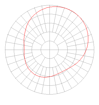 | ||||||||||||||||||
| Azimuth | Ratio | Azimuth | Ratio | Azimuth | Ratio | Azimuth | Ratio | ||||||||||||
| 0 | 0.951 | 10 | 0.975 | 20 | 0.993 | 30 | 1.000 | ||||||||||||
| 40 | 0.996 | 50 | 0.981 | 60 | 0.955 | 70 | 0.920 | ||||||||||||
| 80 | 0.876 | 90 | 0.826 | 100 | 0.771 | 110 | 0.714 | ||||||||||||
| 120 | 0.661 | 130 | 0.615 | 140 | 0.583 | 150 | 0.569 | ||||||||||||
| 160 | 0.571 | 170 | 0.586 | 180 | 0.607 | 190 | 0.627 | ||||||||||||
| 200 | 0.640 | 210 | 0.645 | 220 | 0.641 | 230 | 0.631 | ||||||||||||
| 240 | 0.613 | 250 | 0.592 | 260 | 0.579 | 270 | 0.570 | ||||||||||||
| 280 | 0.579 | 290 | 0.610 | 300 | 0.650 | 310 | 0.699 | ||||||||||||
| 320 | 0.759 | 330 | 0.817 | 340 | 0.869 | 350 | 0.914 | ||||||||||||
Structure Registration Number 1035360 Structure Type: TOWER Registered To: Gray Media Group, Inc. Structure Address: 1.35 Miles South Of Wacahoota, FL County Name: Alachua County ASR Issued: 09/09/2020 Date Built: 09/01/1982 Site Elevation: 19.5 m (64 ft.) Structure Height: 281.7 m (924 ft.) Height Overall: 299.5 m (983 ft.) Overall Height AMSL: 319 m (1047 ft.) FAA Determination: 10/23/1997 FAA Study #: 97-ASO-4541-OE FAA Circular #: 70/7460-1J Paint & Light FAA Chapters: 4, 7, 13 29-32-12.0 N 82-23-59.0 W (NAD 83) 29-32-11.1 N 82-23-59.6 W (Converted to NAD 27) |
4370 Peachtree Road, Ne Atlanta, GA 30319 Phone: 202-750-1585 Limited Liability Company | Title: Assistant Secretary Date: 03/22/2024 Application Certifier Gray Television Licensee, Llc 4370 Peachtree Road, Ne Atlanta, GA 30319 Applicant Joseph M. Davis, P.E. Chesapeake Rf Consultants, Llc 207 Old Dominion Road Yorktown, VA 23692 Consulting Engineer Joan Stewart Wiley Rein Llp 2050 M Street Nw Washington, DC 20036 | |||||||||||||||||