
FCCInfo.com
A Service of Cavell, Mertz & Associates, Inc.
(855) FCC-INFO
|
|
KNPL-LD from 08/20/2009 KNPL-LD from 12/17/1982 |
|
|
|||||||||||||||||
|
|
Status: STA – Special Temporary Authority (Licensed And Silent) Application Accepted: 04/01/2024 STA Expires: 09/23/2024 File Number: -0000242733 FCC Website Links: LMS Facility Details This Application Other KNPL-LD Applications Including Superseded Applications Mailing Address Correspondence for KNPL-LD Correspondence related to application -0000242733 Service Contour - Open Street Map or USGS Map (51 dBu) Service Contour - KML / Google Earth (51 dBu) Rabbit Ears Info Search for KNPL-LD Site Location: 41-12-13.0 N 100-44-00.0 W (NAD 83) Site Location: 41-12-13.0 N 100-43-58.5 W (Converted to NAD 27) ERP: 9.5 kW Polarization: Horizontally polarized Electrical Beam Tilt: 1.75 degrees R/C AGL: 76.2 m (250 ft.) R/C AMSL: 996 m (3268 ft.) Emission Mask: Full Service Site Elevation: 919.8 m. (3018 ft.) Height Overall*: 185.6 m (609 ft.) (* As Filed In This Application, may differ from ASR Data, Below.) Directional Antenna - Antenna Make/Model: Scala SL-8 Antenna ID: 23503 Polarization: Horizontally polarized
| |||||||||||||||||||
| Antenna Data for Antenna Id: 23503 KNPL-LD LD File: -0000242733 Scala - SL-8 Service: LD Standard Pattern: Y Pattern and Field Values Include a 200° Clockwise Rotation | 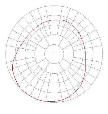 | |||||||||||||||||||
| Azimuth | Ratio | Azimuth | Ratio | Azimuth | Ratio | Azimuth | Ratio | |||||||||||||
| 0 | 0.700 | 10 | 0.710 | 20 | 0.720 | 30 | 0.700 | |||||||||||||
| 40 | 0.690 | 50 | 0.670 | 60 | 0.650 | 70 | 0.640 | |||||||||||||
| 80 | 0.640 | 90 | 0.650 | 100 | 0.660 | 110 | 0.690 | |||||||||||||
| 120 | 0.740 | 130 | 0.790 | 140 | 0.850 | 150 | 0.890 | |||||||||||||
| 160 | 0.930 | 170 | 0.960 | 180 | 0.980 | 190 | 0.990 | |||||||||||||
| 200 | 1.000 | 210 | 0.990 | 220 | 0.990 | 230 | 0.970 | |||||||||||||
| 240 | 0.940 | 250 | 0.910 | 260 | 0.850 | 270 | 0.780 | |||||||||||||
| 280 | 0.730 | 290 | 0.680 | 300 | 0.660 | 310 | 0.650 | |||||||||||||
| 320 | 0.650 | 330 | 0.660 | 340 | 0.680 | 350 | 0.690 | |||||||||||||
Structure Registration Number 1048076 Structure Type: TOWER Registered To: Gray Media Group, Inc. Structure Address: 4.7 Miles Northeast Of Center North Platte, NE County Name: Lincoln County ASR Issued: 09/09/2020 Date Built: 01/01/1940 Site Elevation: 919.8 m (3018 ft.) Structure Height: 185.6 m (609 ft.) Height Overall: 185.6 m (609 ft.) Overall Height AMSL: 1105.4 m (3627 ft.) Paint & Light FAA Chapters: 1, 3, 5, 14, 21 41-12-13.0 N 100-44-00.0 W (NAD 83) 41-12-13.0 N 100-43-58.5 W (Converted to NAD 27) |
4370 Peachtree Road, Ne Atlanta, GA 30319 Phone: 404-504-9828 Limited Liability Company | Title: Assistant Secretary Date: 04/01/2024 Application Certifier Gray Television Licensee, Llc 4370 Peachtree Road, Ne Atlanta, GA 30319 Applicant Joan Stewart Wiley Rein Llp 2050 M Street, Nw Washington, DC 20036 | ||||||||||||||||||