
FCCInfo.com
A Service of Cavell, Mertz & Associates, Inc.
(855) FCC-INFO
|
|
KTKV-LD from 12/13/2011 |
|
|
||||||||||||||||
|
|
Status: Construction Permit Application Accepted: 04/09/2024 KTKV-LD CP Expires: 04/17/2027 File Number: -0000243278 FCC Website Links: LMS Facility Details This Application Other KTKV-LD Applications Including Superseded Applications Mailing Address Correspondence for KTKV-LD Correspondence related to application -0000243278 Service Contour - Open Street Map or USGS Map (51 dBu) Service Contour - KML / Google Earth (51 dBu) Rabbit Ears Info Search for KTKV-LD Site Location: 42-43-44.0 N 114-24-59.0 W (NAD 83) Site Location: 42-43-44.3 N 114-24-55.9 W (Converted to NAD 27) ERP: 15 kW Polarization: Horizontally polarized Electrical Beam Tilt: 1 degree R/C AGL: 22.9 m (75 ft.) R/C AMSL: 1324.9 m (4347 ft.) Emission Mask: Full Service Site Elevation: 1302 m. (4272 ft.) Height Overall*: 46.6 m (153 ft.) (* As Filed In This Application, may differ from ASR Data, Below.) Directional Antenna - Antenna Make/Model: Propagation System Inc PSILPD16AW-23/26 Antenna ID: 1011620 Polarization: Horizontally polarized | ||||||||||||||||||
| Antenna Data for Antenna Id: 1011620 KTKV-LD LD File: -0000243278 Propagation System Inc - PSILPD16AW-23/26 Service: LD Standard Pattern: N Pattern and Field Values Include a 200° Clockwise Rotation | 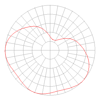 | ||||||||||||||||||
| Azimuth | Ratio | Azimuth | Ratio | Azimuth | Ratio | Azimuth | Ratio | ||||||||||||
| 0 | 0.302 | 10 | 0.253 | 20 | 0.241 | 30 | 0.253 | ||||||||||||
| 40 | 0.302 | 50 | 0.397 | 60 | 0.510 | 70 | 0.605 | ||||||||||||
| 80 | 0.680 | 90 | 0.758 | 100 | 0.845 | 110 | 0.922 | ||||||||||||
| 120 | 0.975 | 130 | 0.997 | 140 | 0.990 | 150 | 0.959 | ||||||||||||
| 160 | 0.929 | 170 | 0.925 | 180 | 0.951 | 190 | 0.985 | ||||||||||||
| 200 | 1.000 | 210 | 0.985 | 220 | 0.951 | 230 | 0.925 | ||||||||||||
| 240 | 0.929 | 250 | 0.959 | 260 | 0.990 | 270 | 0.997 | ||||||||||||
| 280 | 0.975 | 290 | 0.922 | 300 | 0.845 | 310 | 0.758 | ||||||||||||
| 320 | 0.680 | 330 | 0.605 | 340 | 0.510 | 350 | 0.397 | ||||||||||||
Structure Registration Number 1041029 Structure Type: TOWER Registered To: Christian Broadcasting of Idaho, Inc. Structure Address: Atop Flat Top Butte Jerome, ID County Name: Jerome County ASR Issued: 08/27/2002 Date Built: 04/20/1998 Site Elevation: 1302 m (4272 ft.) Structure Height: 46.6 m (153 ft.) Height Overall: 46.6 m (153 ft.) Overall Height AMSL: 1348.6 m (4425 ft.) FAA Determination: 09/26/1997 FAA Study #: 97-ANM-1135-OE FAA Circular #: 70/7460-1J Paint & Light FAA Chapters: 4, 5, 13 42-43-44.0 N 114-24-59.0 W (NAD 83) 42-43-44.3 N 114-24-55.9 W (Converted to NAD 27) |
Fresno, CA 93702 Phone: 866-436-6388 Limited Liability Company | Title: Managing Member Date: 04/09/2024 Application Certifier VENTURA MEDIA COMMUNICATIONS LLC Ventura Media Communications Llc Fresno, CA 93702 Applicant Joseph M. Davis, P.E. Chesapeake Rf Consultants, Llc 207 Old Dominion Road Yorktown, VA 23692 Consulting Engineer Kathleen Victory Fletcher Heald & Hildreth, Plc 1300 N. 17th Street Suite 1100 Arlington, VA 22209 FCC Counsel | |||||||||||||||||
