
FCCInfo.com
A Service of Cavell, Mertz & Associates, Inc.
(855) FCC-INFO
|
|
WLNM-LD from 07/08/2009 WLNM-LD from 11/25/2003 WLNM-LD from 11/25/1986 |
|
|
||||||||||||||||
|
|
Status: Construction Permit Application Accepted: 04/25/2024 WLNM-LD CP Expires: 05/01/2027 File Number: -0000240084 FCC Website Links: LMS Facility Details This Application Other WLNM-LD Applications Including Superseded Applications Mailing Address Correspondence for WLNM-LD Correspondence related to application -0000240084 Service Contour - Open Street Map or USGS Map (51 dBu) Service Contour - KML / Google Earth (51 dBu) Rabbit Ears Info Search for WLNM-LD Site Location: 42-42-06.9 N 84-24-47.8 W (NAD 83) Site Location: 42-42-06.8 N 84-24-47.9 W (Converted to NAD 27) ERP: 15 kW Polarization: Elliptically polarized Electrical Beam Tilt: 1.0 degree R/C AGL: 249.9 m (820 ft.) R/C AMSL: 509 m (1670 ft.) Emission Mask: Full Service Site Elevation: 259.1 m. (850 ft.) Height Overall*: 313.3 m (1028 ft.) (* As Filed In This Application, may differ from ASR Data, Below.) Directional Antenna - Antenna Make/Model: Dielectric TLP-12W/VP Antenna ID: 1011648 Polarization: Elliptically polarized | ||||||||||||||||||
| Antenna Data for Antenna Id: 1011648 WLNM-LD LD File: -0000240084 Dielectric - TLP-12W/VP Service: LD Standard Pattern: N Pattern and Field Values Include a 270° Clockwise Rotation | 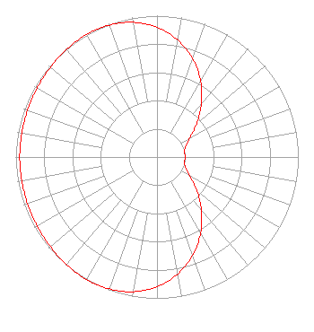 | ||||||||||||||||||
| Azimuth | Ratio | Azimuth | Ratio | Azimuth | Ratio | Azimuth | Ratio | ||||||||||||
| 0 | 0.918 | 10 | 0.841 | 20 | 0.739 | 30 | 0.617 | ||||||||||||
| 40 | 0.488 | 50 | 0.365 | 60 | 0.268 | 70 | 0.214 | ||||||||||||
| 80 | 0.199 | 90 | 0.199 | 100 | 0.199 | 110 | 0.214 | ||||||||||||
| 120 | 0.268 | 130 | 0.365 | 140 | 0.488 | 150 | 0.617 | ||||||||||||
| 160 | 0.739 | 170 | 0.841 | 180 | 0.918 | 190 | 0.968 | ||||||||||||
| 200 | 0.993 | 210 | 1.000 | 220 | 0.995 | 230 | 0.986 | ||||||||||||
| 240 | 0.978 | 250 | 0.974 | 260 | 0.972 | 270 | 0.972 | ||||||||||||
| 280 | 0.972 | 290 | 0.974 | 300 | 0.978 | 310 | 0.986 | ||||||||||||
| 320 | 0.995 | 330 | 1.000 | 340 | 0.993 | 350 | 0.968 | ||||||||||||
Structure Registration Number 1265362 Structure Type: TOWER Registered To: Board of Trustees, Michigan State University Structure Address: 4101 Dobie Road Okemos, MI County Name: Ingham County ASR Issued: 12/22/2011 Date Built: 07/05/2011 Site Elevation: 259.1 m (850 ft.) Structure Height: 297.8 m (977 ft.) Height Overall: 313.3 m (1028 ft.) Overall Height AMSL: 572.4 m (1878 ft.) FAA Determination: 12/08/2011 FAA Study #: 2011-AGL-4543-OE FAA Circular #: 70/7460-1K Paint & Light FAA Chapters: 3, 4, 5, 12 PRIOR STUDY 2008-AGL-4484-OE 42-42-06.9 N 84-24-47.8 W (NAD 83) 42-42-06.8 N 84-24-47.9 W (Converted to NAD 27) |
4370 Peachtree Rd, Ne Atlanta, GA 30319 Phone: 404-266-8333 Limited Liability Company | Title: Assistant Secretary Date: 04/25/2024 Application Certifier Gray Television Licensee, Llc 4370 Peachtree Rd, Ne Atlanta, GA 30319 Applicant Joan Stewart Wiley Rein Llp 2050 M Street, Nw Washington, DC 20036 Joseph M. Davis, P.E. Chesapeake Rf Consultants, Llc 207 Old Dominion Road Yorktown, VA 23692 Consulting Engineer | |||||||||||||||||