
FCCInfo.com
A Service of Cavell, Mertz & Associates, Inc.
(855) FCC-INFO
|
|
DKHPB-CD from 01/04/2002 DKHPB-CD from 04/08/1996 DKHPB-CD from 10/23/1995 DKHPB-CD from 07/18/1995 DKHPB-CD from 10/06/1993 |
Post-repack Channel 16 Virtual Channel 45 |
|
||||||||||||||||
|
|
Repacking Information: Pre-Repack Channel: 45 Post-Repack Channel: 16 Post-Repack ERP: 0.085 kW Phase: 3 Completion Deadline: 6/21/2019 Find nearby TV Facilities Status: License Application Accepted: 07/14/2017 License Expires: 08/01/2022 File Number: -0000028904 FCC Website Links: LMS Facility Details This Application Other DKHPB-CD Applications Including Superseded Applications Mailing Address Correspondence for DKHPB-CD Correspondence related to application -0000028904 Service Contour - Open Street Map or USGS Map (51 dBu) Service Contour - KML / Google Earth (51 dBu) Public Inspection Files Rabbit Ears Info Search for DKHPB-CD Site Location: 30-08-59.6 N 97-13-16.3 W (NAD 83) Site Location: 30-08-58.8 N 97-13-15.3 W (Converted to NAD 27) ERP: 0.158 kW Polarization: Horizontally polarized Electrical Beam Tilt: 0.5 degrees R/C AGL: 122 m (400 ft.) R/C AMSL: 266.8 m (875 ft.) Emission Mask: Stringent Site Elevation: 144.8 m. (475 ft.) Height Overall*: 150.6 m (494 ft.) (* As Filed In This Application, may differ from ASR Data, Below.) Directional Antenna - Antenna Make/Model: Andrew ALP16L2-HSOC Antenna ID: 16531 Polarization: Horizontally polarized | ||||||||||||||||||
| Antenna Data for Antenna Id: 16531 DKHPB-CD DC File: -0000028904 Andrew - ALP16L2-HSOC Service: DC Standard Pattern: Y | 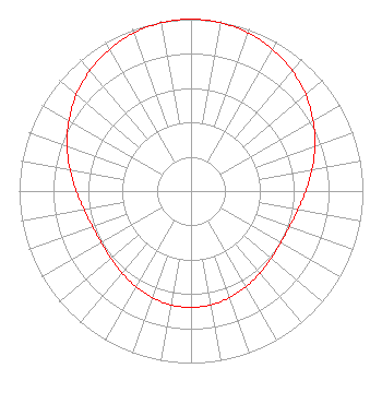 | ||||||||||||||||||
| Azimuth | Ratio | Azimuth | Ratio | Azimuth | Ratio | Azimuth | Ratio | ||||||||||||
| 0 | 1.000 | 10 | 0.994 | 20 | 0.978 | 30 | 0.951 | ||||||||||||
| 40 | 0.915 | 50 | 0.871 | 60 | 0.820 | 70 | 0.767 | ||||||||||||
| 80 | 0.715 | 90 | 0.668 | 100 | 0.631 | 110 | 0.609 | ||||||||||||
| 120 | 0.602 | 130 | 0.608 | 140 | 0.623 | 150 | 0.642 | ||||||||||||
| 160 | 0.659 | 170 | 0.672 | 180 | 0.676 | 190 | 0.672 | ||||||||||||
| 200 | 0.659 | 210 | 0.642 | 220 | 0.623 | 230 | 0.608 | ||||||||||||
| 240 | 0.602 | 250 | 0.609 | 260 | 0.631 | 270 | 0.668 | ||||||||||||
| 280 | 0.715 | 290 | 0.767 | 300 | 0.820 | 310 | 0.871 | ||||||||||||
| 320 | 0.915 | 330 | 0.951 | 340 | 0.978 | 350 | 0.994 | ||||||||||||
Structure Registration Number 1050617 Structure Type: GTOWER Registered To: Global Tower, LLC. through American Towers, LLC Structure Address: .3 Mi S Of Sr 21, .25 Mi E Of Cr1441 Sr 21 Jct Bastrop, TX County Name: Bastrop County ASR Issued: 05/16/2017 Date Built: 01/06/1993 Site Elevation: 144.8 m (475 ft.) Structure Height: 146 m (479 ft.) Height Overall: 150.6 m (494 ft.) Overall Height AMSL: 295.4 m (969 ft.) FAA Determination: 04/02/1998 FAA Study #: 98-ASW-0687-OE FAA Circular #: 70/7460-1G Paint & Light FAA Chapters: 4, 6, 9 OM&L = 24-HR MED-STROBES 30-08-59.6 N 97-13-16.3 W (NAD 83) 30-08-58.8 N 97-13-15.3 W (Converted to NAD 27) |
545 E. John Carpenter Freeway Suite 700 Irving, TX 75062 Phone: 972-373-8800 Corporation | Title: General Counsel Date: 07/14/2017 Application Certifier Nexstar Broadcasting, Inc. 545 E. John Carpenter Freeway Suite 700 Irving, TX 75062 Applicant Elizabeth Ryder Nexstar Broadcasting, Inc. 545 E. John Carpenter Freeway Suite 700 Irving, TX 75062 General Counsel | |||||||||||||||||