
FCCInfo.com
A Service of Cavell, Mertz & Associates, Inc.
(855) FCC-INFO
|
|
DWCDC-TV from 04/06/1981 |
RF spectrum relinquished in the spectrum auction Virtual Channel 19 |  |
|
|||||||||||||||
|
|
Repacking Information: Channel 36 was relinquished in the spectrum auction Status: License Application Accepted: 02/12/2018 License Expires: 04/01/2023 File Number: -0000041893 FCC Website Links: LMS Facility Details This Application Other DWCDC-TV Applications Including Superseded Applications Mailing Address Correspondence for DWCDC-TV Correspondence related to application -0000041893 Service Contour - Open Street Map or USGS Map (41 dBu) Service Contour - KML / Google Earth (41 dBu) Public Inspection Files History Cards for DWCDC-TV Rabbit Ears Info Search for DWCDC-TV Site Location: 42-38-14.0 N 73-10-06.0 W (NAD 83) Site Location: 42-38-13.7 N 73-10-07.6 W (Converted to NAD 27) ERP: 27.5 kW Polarization: Horizontally polarized HAAT: 631 m (2070 ft.) Electrical Beam Tilt: 0.5 degrees R/C AGL: 54 m (177 ft.) R/C AMSL: 1102 m (3615 ft.) Site Elevation: 1048 m. (3438 ft.) Height Overall*: 76 m (249 ft.) (* As Filed In This Application, may differ from ASR Data, Below.) Directional Antenna - Antenna Make/Model: DIELECTRIC TLP-24B(C) Antenna ID: 86628 Polarization: Horizontally polarized | ||||||||||||||||||
| Antenna Data for Antenna Id: 86628 DWCDC-TV DT File: -0000041893 DIELECTRIC - TLP-24B(C) Service: DT Standard Pattern: Y | 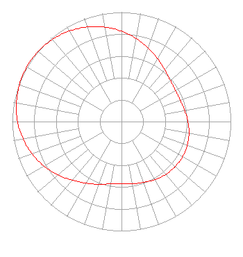 | ||||||||||||||||||
| Azimuth | Ratio | Azimuth | Ratio | Azimuth | Ratio | Azimuth | Ratio | ||||||||||||
| 0 | 0.826 | 10 | 0.771 | 20 | 0.714 | 30 | 0.661 | ||||||||||||
| 40 | 0.615 | 50 | 0.583 | 60 | 0.569 | 70 | 0.571 | ||||||||||||
| 80 | 0.586 | 90 | 0.607 | 100 | 0.627 | 110 | 0.640 | ||||||||||||
| 120 | 0.645 | 130 | 0.641 | 140 | 0.631 | 150 | 0.613 | ||||||||||||
| 160 | 0.592 | 170 | 0.579 | 180 | 0.570 | 190 | 0.579 | ||||||||||||
| 200 | 0.610 | 210 | 0.650 | 220 | 0.699 | 230 | 0.759 | ||||||||||||
| 240 | 0.817 | 250 | 0.869 | 260 | 0.914 | 270 | 0.951 | ||||||||||||
| 280 | 0.975 | 290 | 0.993 | 300 | 1.000 | 310 | 0.996 | ||||||||||||
| 320 | 0.981 | 330 | 0.955 | 340 | 0.920 | 350 | 0.876 | ||||||||||||
Structure Registration Number 1035419 Structure Type: TOWER Registered To: WAMC Structure Address: Mount Greylock Williamstown, MA County Name: Berkshire County ASR Issued: 07/07/2023 Date Built: 01/01/1983 Site Elevation: 1048 m (3438 ft.) Structure Height: 61 m (200 ft.) Height Overall: 76 m (249 ft.) Overall Height AMSL: 1124 m (3688 ft.) Paint & Light FAA Chapters: 1, 3, 11, 21 42-38-14.0 N 73-10-06.0 W (NAD 83) 42-38-13.7 N 73-10-07.6 W (Converted to NAD 27) |
545 E. John Carpenter Freeway Suite 700 Irving, TX 75062 Phone: 972-373-8800 Corporation | Title: General Counsel Date: 02/12/2018 Application Certifier Nexstar Broadcasting, Inc. 545 E. John Carpenter Freeway Suite 700 Irving, TX 75062 Applicant Elizabeth Ryder Nexstar Broadcasting, Inc. 545 E. John Carpenter Freeway Suite 700 Irving, TX 75062 General Counsel | |||||||||||||||||