
FCCInfo.com
A Service of Cavell, Mertz & Associates, Inc.
(855) FCC-INFO
|
|
WRLW-CD from 05/13/2015 WRLW-CD from 04/26/1996 WRLW-CD from 01/04/1989 |
Post-repack Channel 21 |  |
|
|||||||||||||||
|
|
Repacking Information: Pre-Repack Channel: 17 Post-Repack Channel: 21 Post-Repack ERP: 0.058 kW Phase: 7 Completion Deadline: 1/17/2020 Find nearby TV Facilities Status: License Application Accepted: 04/30/2020 License Expires: 08/02/2021 File Number: -0000112941 FCC Website Links: LMS Facility Details This Application Other WRLW-CD Applications Including Superseded Applications Mailing Address Correspondence for WRLW-CD Correspondence related to application -0000112941 Service Contour - Open Street Map or USGS Map (51 dBu) Service Contour - KML / Google Earth (51 dBu) Public Inspection Files Rabbit Ears Info Search for WRLW-CD Site Location: 38-35-59.0 N 86-05-17.0 W (NAD 83) Site Location: 38-35-58.8 N 86-05-17.1 W (Converted to NAD 27) ERP: 10.5 kW Polarization: Horizontally polarized R/C AGL: 77.7 m (255 ft.) R/C AMSL: 349 m (1145 ft.) Emission Mask: Stringent Site Elevation: 271.3 m. (890 ft.) Height Overall*: 90.8 m (298 ft.) (* As Filed In This Application, may differ from ASR Data, Below.) Directional Antenna - Antenna Make/Model: Propagation System Inc PSILP16OI Antenna ID: 20399 Polarization: Horizontally polarized | ||||||||||||||||||
| Antenna Data for Antenna Id: 20399 WRLW-CD DC File: -0000112941 Propagation System Inc - PSILP16OI Service: DC Standard Pattern: Y Pattern and Field Values Include a 235° Clockwise Rotation | 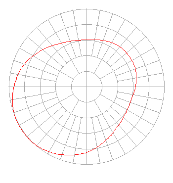 | ||||||||||||||||||
| Azimuth | Ratio | Azimuth | Ratio | Azimuth | Ratio | Azimuth | Ratio | ||||||||||||
| 5 | 0.600 | 15 | 0.620 | 25 | 0.640 | 35 | 0.660 | ||||||||||||
| 45 | 0.670 | 55 | 0.670 | 65 | 0.670 | 75 | 0.660 | ||||||||||||
| 85 | 0.640 | 95 | 0.620 | 105 | 0.600 | 115 | 0.600 | ||||||||||||
| 125 | 0.610 | 135 | 0.630 | 145 | 0.660 | 155 | 0.710 | ||||||||||||
| 165 | 0.760 | 175 | 0.820 | 185 | 0.870 | 195 | 0.910 | ||||||||||||
| 205 | 0.950 | 215 | 0.980 | 225 | 1.000 | 235 | 1.000 | ||||||||||||
| 245 | 1.000 | 255 | 0.980 | 265 | 0.950 | 275 | 0.910 | ||||||||||||
| 285 | 0.870 | 295 | 0.820 | 305 | 0.760 | 315 | 0.710 | ||||||||||||
| 325 | 0.660 | 335 | 0.630 | 345 | 0.610 | 355 | 0.600 | ||||||||||||
Structure Registration Number 1062617 Structure Type: TOWER Registered To: MARTIN, DON H Structure Address: Salem Reservoir St Rt 60 Salem, IN County Name: Washington County ASR Issued: 03/29/1999 Date Built: 01/27/1982 Site Elevation: 271.3 m (890 ft.) Structure Height: 89.9 m (295 ft.) Height Overall: 90.8 m (298 ft.) Overall Height AMSL: 362.1 m (1188 ft.) FAA Determination: 02/25/1988 FAA Study #: 88-AGL-227-OE Paint & Light FAA Chapters: 1, 3, 11, 21 RED LIGHTS/PAINT 38-35-59.0 N 86-05-17.0 W (NAD 83) 38-35-58.8 N 86-05-17.1 W (Converted to NAD 27) |
1308 East Hackberry Street Salem, IN 47167 Phone: 812-883-5750 Limited Liability Company | Title: Owner/gm Date: 04/30/2020 Application Certifier REBECCA L. WHITE Salem Media Llc 1308 East Hackberry Street Salem, IN 47167 Applicant Byron St. Clair B.w. St. Clair 2355 Ranch Drive Westminster, CO 80234 Consulting Engineer | |||||||||||||||||