
FCCInfo.com
A Service of Cavell, Mertz & Associates, Inc.
(855) FCC-INFO
|
|
K24NS-D from 11/16/2001 |
|
|
||||||||||||||||
|
|
Status: License Application Accepted: 05/04/2021 License Expires: 10/03/2022 File Number: -0000144489 FCC Website Links: LMS Facility Details This Application Other K24NS-D Applications Including Superseded Applications Mailing Address Correspondence for K24NS-D Correspondence related to application -0000144489 Service Contour - Open Street Map or USGS Map (51 dBu) Service Contour - KML / Google Earth (51 dBu) Rabbit Ears Info Search for K24NS-D Site Location: 38-57-35.0 N 119-56-24.0 W (NAD 83) Site Location: 38-57-35.3 N 119-56-20.3 W (Converted to NAD 27) ERP: 15 kW Polarization: Horizontally polarized Electrical Beam Tilt: 0.2 degrees R/C AGL: 73 m (240 ft.) R/C AMSL: 1988.4 m (6524 ft.) Emission Mask: Full Service Site Elevation: 1915.4 m. (6284 ft.) Height Overall*: 77.1 m (253 ft.) (* As Filed In This Application, may differ from ASR Data, Below.) Directional Antenna - Antenna Make/Model: Kathrein 3x2 750 10210 Antenna ID: 1008148 Polarization: Horizontally polarized | ||||||||||||||||||
| Antenna Data for Antenna Id: 1008148 K24NS-D LD File: -0000144489 Kathrein - 3x2 750 10210 Service: LD Standard Pattern: N | 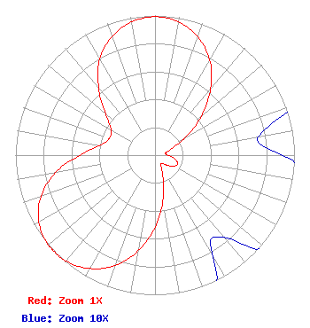 | ||||||||||||||||||
| Azimuth | Ratio | Azimuth | Ratio | Azimuth | Ratio | Azimuth | Ratio | ||||||||||||
| 0 | 0.991 | 10 | 0.969 | 20 | 0.899 | 30 | 0.785 | ||||||||||||
| 40 | 0.620 | 50 | 0.431 | 60 | 0.248 | 70 | 0.116 | ||||||||||||
| 80 | 0.075 | 90 | 0.091 | 100 | 0.140 | 110 | 0.174 | ||||||||||||
| 120 | 0.159 | 130 | 0.112 | 140 | 0.077 | 150 | 0.082 | ||||||||||||
| 160 | 0.166 | 170 | 0.329 | 180 | 0.518 | 190 | 0.696 | ||||||||||||
| 200 | 0.842 | 210 | 0.937 | 220 | 0.991 | 227 | 1.000 | ||||||||||||
| 230 | 0.999 | 240 | 0.961 | 250 | 0.871 | 260 | 0.726 | ||||||||||||
| 270 | 0.537 | 280 | 0.400 | 290 | 0.349 | 300 | 0.364 | ||||||||||||
| 310 | 0.463 | 320 | 0.629 | 330 | 0.794 | 340 | 0.904 | ||||||||||||
| 350 | 0.969 | ||||||||||||||||||
Structure Registration Number 1042810 Structure Type: BPOLE Registered To: HARRAH'S OPERATING COMPANY, INC. DBA = HARRAH'S CASINO, HOTEL-LAKE TAH Structure Address: 15 Highway 50 Stateline, NV County Name: Douglas County ASR Issued: 03/31/2003 Date Built: 01/01/1977 Site Elevation: 1915.4 m (6284 ft.) Structure Height: 68 m (223 ft.) Height Overall: 77.1 m (253 ft.) Overall Height AMSL: 1992.5 m (6537 ft.) FAA Determination: 04/06/1998 FAA Study #: 98-AWP-1144-OE Paint & Light FAA Chapters: None 38-57-35.0 N 119-56-24.0 W (NAD 83) 38-57-35.3 N 119-56-20.3 W (Converted to NAD 27) |
1600 Pearl Street Suite 300 Boulder, CO 80302 Phone: 855-688-0567 Limited Liability Company | Title: Cfo Of Sole Member Date: 05/04/2021 Application Certifier Outside Waves Llc 5720 Flatiron Parkway Suite 100 Boulder, CO 80301 Applicant William Jeffrey Reynolds Du Treil, Lundin & Rackley, Inc. 5120 Station Way Sarasota, FL 34233-3221 Technical Consultant Henry Wendel Cooley Llp 1299 Pennsylvania Avenue, Nw Suite 700 Washington, DC 20004 FCC Counsel | |||||||||||||||||