
FCCInfo.com
A Service of Cavell, Mertz & Associates, Inc.
(855) FCC-INFO
|
|
K24NR-D from 07/26/2004 |
|
|
||||||||||||||||
|
|
Status: License Application Accepted: 09/27/2021 License Expires: 08/01/2022 File Number: -0000160506 FCC Website Links: LMS Facility Details This Application Other K24NR-D Applications Including Superseded Applications Mailing Address Correspondence for K24NR-D Correspondence related to application -0000160506 Service Contour - Open Street Map or USGS Map (51 dBu) Service Contour - KML / Google Earth (51 dBu) Rabbit Ears Info Search for K24NR-D Site Location: 35-13-28.2 N 101-39-09.6 W (NAD 83) Site Location: 35-13-28.0 N 101-39-08.0 W (Converted to NAD 27) ERP: 0.05 kW Polarization: Horizontally polarized R/C AGL: 10 m (33 ft.) R/C AMSL: 1094.2 m (3590 ft.) Emission Mask: Stringent Site Elevation: 1084.2 m. (3557 ft.) Height Overall*: 31.7 m (104 ft.) (* As Filed In This Application, may differ from ASR Data, Below.) Directional Antenna - Antenna Make/Model: Scala CL-1469 Antenna ID: 36576 Polarization: Horizontally polarized | ||||||||||||||||||
| Antenna Data for Antenna Id: 36576 K24NR-D LD File: -0000160506 Scala - CL-1469 Service: LD Standard Pattern: Y Pattern and Field Values Include a 40° Clockwise Rotation | 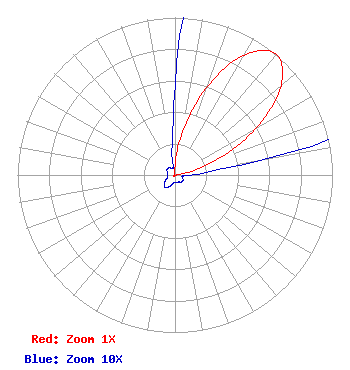 | ||||||||||||||||||
| Azimuth | Ratio | Azimuth | Ratio | Azimuth | Ratio | Azimuth | Ratio | ||||||||||||
| 0 | 0.057 | 10 | 0.282 | 20 | 0.593 | 30 | 0.879 | ||||||||||||
| 40 | 1.000 | 50 | 0.879 | 60 | 0.593 | 70 | 0.282 | ||||||||||||
| 80 | 0.057 | 90 | 0.010 | 100 | 0.005 | 110 | 0.005 | ||||||||||||
| 120 | 0.006 | 130 | 0.006 | 140 | 0.006 | 150 | 0.005 | ||||||||||||
| 160 | 0.005 | 170 | 0.005 | 180 | 0.005 | 190 | 0.005 | ||||||||||||
| 200 | 0.007 | 210 | 0.009 | 220 | 0.010 | 230 | 0.009 | ||||||||||||
| 240 | 0.007 | 250 | 0.005 | 260 | 0.005 | 270 | 0.005 | ||||||||||||
| 280 | 0.005 | 290 | 0.005 | 300 | 0.006 | 310 | 0.006 | ||||||||||||
| 320 | 0.006 | 330 | 0.005 | 340 | 0.005 | 350 | 0.010 | ||||||||||||
Structure Registration Number 1290362 Structure Type: MTOWER Registered To: SBA Towers IX, LLC Structure Address: 1075 N Fm 1912 (tx16867-a) Amarillo, TX County Name: Potter County ASR Issued: 01/28/2016 Date Built: 05/08/2014 Site Elevation: 1084.2 m (3557 ft.) Structure Height: 30.5 m (100 ft.) Height Overall: 31.7 m (104 ft.) Overall Height AMSL: 1115.9 m (3661 ft.) FAA Determination: 12/09/2015 FAA Study #: 2015-ASW-9386-OE Paint & Light FAA Chapters: NONE PRIOR STUDY 2013-ASW-7857-OE 35-13-28.2 N 101-39-09.6 W (NAD 83) 35-13-28.0 N 101-39-08.0 W (Converted to NAD 27) |
1498 Buford Hwy Ste C 275 Sugar Hill, GA 30518 Phone: 770-771-1644 Corporation | Title: President Date: 09/27/2021 Application Certifier PRISM BROADCASTING NEWORK, INC. Prism Broadcasting Nework, Inc. 7742 Spalding Dr., Suite 475 Norcross, GA 30092 Applicant Jim McDonald B. W. St. Clair 117 East Eleventh St. Loveland, CO 80537 ENGINEERING CONSULTANT | |||||||||||||||||