
FCCInfo.com
A Service of Cavell, Mertz & Associates, Inc.
(855) FCC-INFO
|
|
K29NX-D from 07/02/2019 K29NX-D from 09/22/2011 |
|
|
||||||||||||||||
|
|
Status: License Application Accepted: 12/20/2021 License Expires: 06/01/2029 File Number: -0000177525 FCC Website Links: LMS Facility Details This Application Other K29NX-D Applications Including Superseded Applications Mailing Address Correspondence for K29NX-D Correspondence related to application -0000177525 Service Contour - Open Street Map or USGS Map (51 dBu) Service Contour - KML / Google Earth (51 dBu) Rabbit Ears Info Search for K29NX-D Site Location: 30-54-17.4 N 92-37-28.9 W (NAD 83) Site Location: 30-54-16.7 N 92-37-28.4 W (Converted to NAD 27) ERP: 15 kW Polarization: Horizontally polarized Electrical Beam Tilt: 1.05 degrees R/C AGL: 243.8 m (800 ft.) R/C AMSL: 287.1 m (942 ft.) Emission Mask: Full Service Site Elevation: 43.3 m. (142 ft.) Height Overall*: 304.8 m (1000 ft.) (* As Filed In This Application, may differ from ASR Data, Below.) Directional Antenna - Antenna Make/Model: DIELECTRIC TFU-8WB S-230 H Antenna ID: 1009050 Polarization: Horizontally polarized | ||||||||||||||||||
| Antenna Data for Antenna Id: 1009050 K29NX-D LD File: -0000177525 DIELECTRIC - TFU-8WB S-230 H Service: LD Standard Pattern: N Pattern and Field Values Include a 20° Clockwise Rotation | 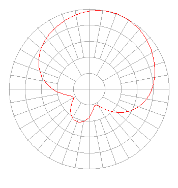 | ||||||||||||||||||
| Azimuth | Ratio | Azimuth | Ratio | Azimuth | Ratio | Azimuth | Ratio | ||||||||||||
| 0 | 0.970 | 10 | 0.991 | 20 | 1.000 | 30 | 0.993 | ||||||||||||
| 40 | 0.972 | 50 | 0.942 | 60 | 0.907 | 70 | 0.870 | ||||||||||||
| 80 | 0.831 | 90 | 0.786 | 100 | 0.729 | 110 | 0.656 | ||||||||||||
| 120 | 0.564 | 130 | 0.456 | 140 | 0.342 | 150 | 0.246 | ||||||||||||
| 160 | 0.221 | 170 | 0.278 | 180 | 0.356 | 190 | 0.414 | ||||||||||||
| 200 | 0.435 | 210 | 0.415 | 220 | 0.357 | 230 | 0.280 | ||||||||||||
| 240 | 0.225 | 250 | 0.249 | 260 | 0.342 | 270 | 0.455 | ||||||||||||
| 280 | 0.563 | 290 | 0.655 | 300 | 0.722 | 310 | 0.780 | ||||||||||||
| 320 | 0.826 | 330 | 0.866 | 340 | 0.903 | 350 | 0.939 | ||||||||||||
Structure Registration Number 1231316 Structure Type: GTOWER Registered To: Delta Media Corporation Structure Address: West Side Of Us 165, 0.7 Mi. North Of Intersection With Route 1153 Glenmora, LA County Name: Rapides Parish ASR Issued: 03/07/2023 Date Built: 04/28/2005 Site Elevation: 43.3 m (142 ft.) Structure Height: 303.8 m (997 ft.) Height Overall: 304.8 m (1000 ft.) Overall Height AMSL: 348.1 m (1142 ft.) FAA Determination: 08/30/2005 FAA Study #: 2005-ASW-4905-OE FAA Circular #: 70/7460-1K Paint & Light FAA Chapters: 4, 7, 12 PRIOR STUDY 2005-ASW-1864-OE 30-54-17.4 N 92-37-28.9 W (NAD 83) 30-54-16.7 N 92-37-28.4 W (Converted to NAD 27) |
3501 Northwest Evangeline Thruway Carencro, LA 70520 Phone: 337-896-1600 Corporation | Title: Officer Date: 12/20/2021 Application Certifier DELTA MEDIA CORPORATION Delta Media Corporation 3501 Northwest Evangeline Thruway Carencro, LA 70520 Applicant Joseph M. Davis, P.E. Chesapeake Rf Consultants, Llc 207 Old Dominion Road Yorktown, VA 23692 Consulting Engineer KATHLEEN VICTORY Fletcher, Heald & Hildreth, Plc 1300 N. 17th Street 11th Floor Arlington, VA 22209 FCC COUNSEL | |||||||||||||||||