
FCCInfo.com
A Service of Cavell, Mertz & Associates, Inc.
(855) FCC-INFO
|
|
|
|
|
||||||||||||||||
|
|
Status: License Application Accepted: 01/06/2022 License Expires: 04/02/2029 File Number: -0000179078 FCC Website Links: LMS Facility Details This Application Other W19DN-D Applications Including Superseded Applications Mailing Address Correspondence for W19DN-D Correspondence related to application -0000179078 Service Contour - Open Street Map or USGS Map (51 dBu) Service Contour - KML / Google Earth (51 dBu) Rabbit Ears Info Search for W19DN-D Site Location: 32-44-58.4 N 83-33-34.5 W (NAD 83) Site Location: 32-44-57.9 N 83-33-34.8 W (Converted to NAD 27) ERP: 15 kW Polarization: Horizontally polarized Electrical Beam Tilt: 0.5 degrees R/C AGL: 207 m (679 ft.) R/C AMSL: 297.8 m (977 ft.) Emission Mask: Full Service Site Elevation: 90.8 m. (298 ft.) Height Overall*: 274.6 m (901 ft.) (* As Filed In This Application, may differ from ASR Data, Below.) Directional Antenna - Antenna Make/Model: Propagation System Inc PSILP16BB Antenna ID: 20385 Polarization: Horizontally polarized | ||||||||||||||||||
| Antenna Data for Antenna Id: 20385 W19DN-D LD File: -0000179078 Propagation System Inc - PSILP16BB Service: LD Standard Pattern: Y Pattern and Field Values Include a 145° Clockwise Rotation | 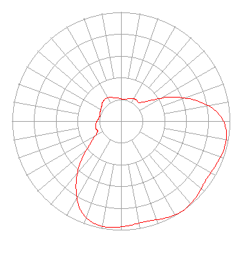 | ||||||||||||||||||
| Azimuth | Ratio | Azimuth | Ratio | Azimuth | Ratio | Azimuth | Ratio | ||||||||||||
| 5 | 0.200 | 15 | 0.210 | 25 | 0.230 | 35 | 0.240 | ||||||||||||
| 45 | 0.240 | 55 | 0.330 | 65 | 0.520 | 75 | 0.720 | ||||||||||||
| 85 | 0.890 | 95 | 0.970 | 105 | 0.980 | 115 | 0.960 | ||||||||||||
| 125 | 0.950 | 135 | 0.980 | 145 | 1.000 | 155 | 0.980 | ||||||||||||
| 165 | 0.950 | 175 | 0.960 | 185 | 0.980 | 195 | 0.970 | ||||||||||||
| 205 | 0.890 | 215 | 0.720 | 225 | 0.520 | 235 | 0.330 | ||||||||||||
| 245 | 0.240 | 255 | 0.240 | 265 | 0.230 | 275 | 0.210 | ||||||||||||
| 285 | 0.200 | 295 | 0.210 | 305 | 0.220 | 315 | 0.240 | ||||||||||||
| 325 | 0.250 | 335 | 0.240 | 345 | 0.220 | 355 | 0.210 | ||||||||||||
Structure Registration Number 1019786 Structure Type: GTOWER Registered To: American Towers LLC Structure Address: 19792 Us Hwy 23 & 129 (303238) Macon, GA County Name: Twiggs County ASR Issued: 01/22/2021 Date Built: 01/01/1982 Site Elevation: 90.8 m (298 ft.) Structure Height: 254.5 m (835 ft.) Height Overall: 274.6 m (901 ft.) Overall Height AMSL: 365.4 m (1199 ft.) FAA Determination: 10/24/2019 FAA Study #: 2019-ASO-31290-OE FAA Circular #: 70/7460-1L Paint & Light FAA Chapters: 4, 9, 12 PRIOR STUDY 2013-ASO-11643-OE 32-44-58.4 N 83-33-34.5 W (NAD 83) 32-44-57.9 N 83-33-34.8 W (Converted to NAD 27) |
2383 Pruneridge Avenue Suite 4 Santa Clara, CA 95050 Phone: 650-952-2331 Corporation | Title: President Date: 01/06/2022 Application Certifier MAJOR MARKET BROADCASTING OF NORTH DAKOTA, INC. Major Market Broadcasting Of North Dakota, Inc. 2383 Pruneridge Avenue Suite 4 Santa Clara, CA 95050 Applicant Davina Sashkin Baker & Hostetler Llp 1050 Connecticut Avenue, Nw Suite 1100 Washington, DC 20036 | |||||||||||||||||