
FCCInfo.com
A Service of Cavell, Mertz & Associates, Inc.
(855) FCC-INFO
|
|
|
|
|
||||||||||||||||
|
|
Status: Construction Permit Application Accepted: 02/17/2022 W04DN-D CP Expires: 02/22/2025 File Number: -0000184995 FCC Website Links: LMS Facility Details This Application Other W04DN-D Applications Including Superseded Applications Mailing Address Correspondence for W04DN-D Correspondence related to application -0000184995 Service Contour - Open Street Map or USGS Map (43 dBu) Service Contour - KML / Google Earth (43 dBu) Rabbit Ears Info Search for W04DN-D Site Location: 32-37-19.3 N 85-30-04.9 W (NAD 83) Site Location: 32-37-18.8 N 85-30-05.1 W (Converted to NAD 27) ERP: 3 kW Polarization: Horizontally polarized R/C AGL: 73 m (240 ft.) R/C AMSL: 275.1 m (903 ft.) Emission Mask: Simple Site Elevation: 202.1 m. (663 ft.) Height Overall*: 140.5 m (461 ft.) (* As Filed In This Application, may differ from ASR Data, Below.) Directional Antenna - Antenna Make/Model: DIELECTRIC TLS-V4B Antenna ID: 1006660 Polarization: Horizontally polarized | ||||||||||||||||||
| Antenna Data for Antenna Id: 1006660 W04DN-D LD File: -0000184995 DIELECTRIC - TLS-V4B Service: LD Standard Pattern: Y Pattern and Field Values Include a 120° Clockwise Rotation | 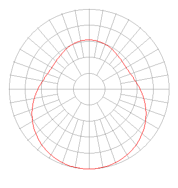 | ||||||||||||||||||
| Azimuth | Ratio | Azimuth | Ratio | Azimuth | Ratio | Azimuth | Ratio | ||||||||||||
| 0 | 0.613 | 10 | 0.608 | 20 | 0.593 | 30 | 0.573 | ||||||||||||
| 40 | 0.552 | 50 | 0.537 | 60 | 0.535 | 70 | 0.551 | ||||||||||||
| 80 | 0.585 | 90 | 0.635 | 100 | 0.693 | 110 | 0.755 | ||||||||||||
| 120 | 0.814 | 130 | 0.869 | 140 | 0.915 | 150 | 0.952 | ||||||||||||
| 160 | 0.978 | 170 | 0.995 | 180 | 1.000 | 190 | 0.995 | ||||||||||||
| 200 | 0.978 | 210 | 0.952 | 220 | 0.915 | 230 | 0.869 | ||||||||||||
| 240 | 0.814 | 250 | 0.755 | 260 | 0.693 | 270 | 0.635 | ||||||||||||
| 280 | 0.585 | 290 | 0.551 | 300 | 0.535 | 310 | 0.537 | ||||||||||||
| 320 | 0.552 | 330 | 0.573 | 340 | 0.593 | 350 | 0.608 | ||||||||||||
Structure Registration Number 1303779 Structure Type: MTOWER Registered To: Pinnacle Towers LLC Structure Address: 925 Foster Street Auburn, AL County Name: Lee County ASR Issued: 10/16/2017 Date Built: 01/10/2019 Site Elevation: 202.1 m (663 ft.) Structure Height: 137.2 m (450 ft.) Height Overall: 140.5 m (461 ft.) Overall Height AMSL: 342.6 m (1124 ft.) FAA Determination: 09/28/2017 FAA Study #: 2017-ASO-13495-OE FAA Circular #: 70/7460-1L Paint & Light FAA Chapters: 4, 8, 12 PRIOR STUDY 1984-ASO-814-OE 32-37-19.3 N 85-30-04.9 W (NAD 83) 32-37-18.8 N 85-30-05.1 W (Converted to NAD 27) |
14 Tuxedo Drive Beaufort, SC 29907 Phone: 717-226-3535 Limited Liability Company | Title: Ceo Date: 02/17/2022 Application Certifier Innovative Media Technologies, Inc. 5174 Mcginnis Ferry Road Suite 133 Alpharetta, GA 30005 Applicant Susan Hansen B. W. St. Clair 2305 Vida Shaw Rd. New Iberia, LA 70563 | |||||||||||||||||