
FCCInfo.com
A Service of Cavell, Mertz & Associates, Inc.
(855) FCC-INFO
|
|
WHNH-CD from 10/18/2013 WHNH-CD from 05/31/2013 WHNH-CD from 10/03/2003 WHNH-CD from 04/24/1998 WHNH-CD from 01/24/1996 |
|
|
||||||||||||||||
|
|
Repacking Information: No changes Status: License Application Accepted: 06/07/2022 License Expires: 04/03/2023 File Number: -0000193069 FCC Website Links: LMS Facility Details This Application Other WHNH-CD Applications Including Superseded Applications Mailing Address Correspondence for WHNH-CD Correspondence related to application -0000193069 Service Contour - Open Street Map or USGS Map (43 dBu) Service Contour - KML / Google Earth (43 dBu) Public Inspection Files Rabbit Ears Info Search for WHNH-CD Site Location: 41-42-13.0 N 72-49-55.0 W (NAD 83) Site Location: 41-42-12.6 N 72-49-56.6 W (Converted to NAD 27) ERP: 3 kW Polarization: Horizontally polarized R/C AGL: 352.1 m (1155 ft.) R/C AMSL: 568.5 m (1865 ft.) Emission Mask: Full Service Site Elevation: 216.4 m. (710 ft.) Height Overall*: 408.1 m (1339 ft.) (* As Filed In This Application, may differ from ASR Data, Below.) Directional Antenna - Antenna Make/Model: Kathrein CL-24 X3 Antenna ID: 1009644 Polarization: Horizontally polarized | ||||||||||||||||||
| Antenna Data for Antenna Id: 1009644 WHNH-CD DC File: -0000193069 Kathrein - CL-24 X3 Service: DC Standard Pattern: N | 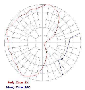 | ||||||||||||||||||
| Azimuth | Ratio | Azimuth | Ratio | Azimuth | Ratio | Azimuth | Ratio | ||||||||||||
| 0 | 0.950 | 10 | 1.000 | 20 | 0.950 | 30 | 0.841 | ||||||||||||
| 40 | 0.640 | 50 | 0.470 | 60 | 0.316 | 70 | 0.158 | ||||||||||||
| 80 | 0.080 | 90 | 0.070 | 100 | 0.067 | 110 | 0.067 | ||||||||||||
| 120 | 0.067 | 130 | 0.067 | 140 | 0.067 | 150 | 0.126 | ||||||||||||
| 160 | 0.324 | 170 | 0.470 | 180 | 0.650 | 190 | 0.850 | ||||||||||||
| 200 | 0.930 | 210 | 1.000 | 220 | 0.950 | 230 | 0.890 | ||||||||||||
| 240 | 0.900 | 250 | 0.870 | 260 | 0.910 | 270 | 0.900 | ||||||||||||
| 280 | 0.940 | 290 | 0.980 | 300 | 0.930 | 310 | 0.900 | ||||||||||||
| 320 | 0.900 | 330 | 0.870 | 340 | 0.910 | 350 | 0.900 | ||||||||||||
Structure Registration Number 1041624 Structure Type: Registered To: COMMUNICATIONS SITE MANAGEMENT, LLC Structure Address: 200 Colt Highway Rt. 6 Farmington, CT County Name: Hartford County ASR Issued: 08/24/2015 Date Built: 09/01/1984 Site Elevation: 216.4 m (710 ft.) Structure Height: 393.8 m (1292 ft.) Height Overall: 408.1 m (1339 ft.) Overall Height AMSL: 624.5 m (2049 ft.) FAA Determination: 01/17/1984 FAA Study #: 83-ANE-0395-OE FAA Circular #: 70/7460-1F Paint & Light FAA Chapters: 4, 6, 9 41-42-13.0 N 72-49-55.0 W (NAD 83) 41-42-12.6 N 72-49-56.6 W (Converted to NAD 27) |
482 Harbor Drive North Indian Rocks Beach, FL 33785 Phone: 607-738-5623 Limited Liability Company | Title: Chief Executive Officer Date: 06/07/2022 Application Certifier Triple Seven Media, Llc 482 Harbor Drive North Indian Rocks Beach, FL 33785 Applicant Mark Denbo Smithwick & Belendiuk, P.c. 5028 Wisconsin Avenue, N.w. Suite 301 Washington, DC 20016 Counsel Carl E Gluck, Consultant Carl T. Jones Corp Carl T Jones Corp 7901 Yarnwood Court Springfield, VA 22153 Technical Consultant | |||||||||||||||||